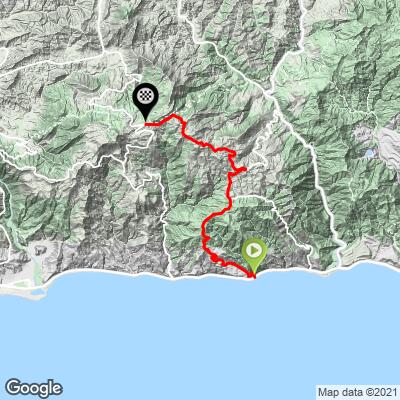
Big Rock to Stunt Road Bike Climb - PJAMM Cycling

4.4
FIETS
7.6 mi
DISTANCE
2,483 ft
GAINED
5.8 %
AVG. GRADE

FULL CLIMB STATS

INTRO

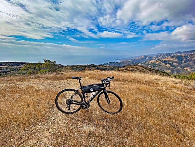
Mixed surfaces, steep gradients, and stunning ocean views make this one of the most fun rides in Malibu.

See more details and tools regarding this climb's grade via our interactive Profile Tool.
Information Not Available

If you have any information regarding this climb, we'd like to hear from you. Click the CONTRIBUTE button to share your thoughts with us.

Information Not Available

If you have any information regarding this climb, we'd like to hear from you. Click the CONTRIBUTE button to share your thoughts with us.

Before heading out on any cycling adventure check out our Things to Bring on a Cycling Trip and use our interactive check list to ensure you don't forget anything.
Information Not Available

If you have any information regarding this climb, we'd like to hear from you. Click the CONTRIBUTE button to share your thoughts with us.

ROUTE MAP

MEMBER RATING

Difficulty: Extreme
5
Road
5
Traffic
5
Scenery

CURRENT WEATHER

PJAMM TRIPS ADVENTURE STARTER BUNDLES

Check out PJAMM Adventure's prepackaged (self-guided) cycling trips. They will help you plan, document and conquer your next adventure.
ALL TRIPS
Browse all of our prepackaged trips and find your next adventure!
Malibu: Santa Monica Mountains
United States (CA)
28 ROUTES
35 POIs
ROUTE STATS (TOTAL)
359.9
mi
DISTANCE
45,284
ft
ELEV. GAIN
San Gabriel Mountains
United States (CA)
38 ROUTES
43 POIs
ROUTE STATS (TOTAL)
677.5
mi
DISTANCE
80,483
ft
ELEV. GAIN

NEARBY CLIMBS (0) RADIAL PROXIMITY

FROM
No Climbs Found

MEMBER REVIEWS & COMMENTS

Let us know what you thought of this climb. Signup for our FREE membership to write a review or post a comment.
Already have an account?

Nov 24, 2023
difficulty: Extreme
scenery: 5
traffic: 5
road: 5
Nov 24, 2023
scenery: 5
traffic: 5
road: 5
Big Rock Drive is paved from PCH and steep. Then after the gate is kinda paved and still steep. Then it becomes great dirt and undulates with offshoots, but I was able to go in the right direction, until I veered towards what is called The Maze, which is steep climb to lookout with outstanding views — worth seeing. I then backtracked and found the end gate, which abuts Tuna Canyon paved roadway.
ROUTE MAP
PROFILE TOOL
Route Data
S.G. (%)
hide
Segment Data
hide

Climb Profile Not Found
CLIMB SUMMARY

Cycling Big Rock Drive to Stunt Road - panoramic view of mountainside and ocean

Cycling Big Rock Drive to Stunt Road

Santa Monica Mountains, California

Ride 7.6 miles gaining 2,487’ at 5.8% average grade.

Cycling Big Rock Drive to Stunt Road - photo collage, City of Malibu Sign, Big Rock Drive sign, bike parked on side of road next to sign for "Not a Through Street"

Start on Pacific Coast Highway and Big Rock Drive.

Note and Warning:  A portion of this climb is on what is marked as a private roadway.  However, 259 Strava members had ridden this route as of December 2020.  There is a one-third mile stretch between the No Trespassing sign and the gate to enter Santa Monica Mountains Conservancy Parkland (see sign, below). We rode this climb without incident, but we must advise that you undertake this route at your own risk and we cannot formally recommend this route.

Cycling Big Rock Drive to Stunt Road - road sign reads "End of City Mandated Road, Dead End, Private Road"

Cycling Big Rock Drive to Stunt Road - PJAMM Adventure App shows climb grade and profile

PJAMM Adventure App showing gradient for climb.

Cycling Big Rock Drive to Stunt Road - bike parked against guardrail overlooking Pacific Ocean

View of the Pacific Ocean about one-half mile up the climb.

Cycling Big Rock Drive to Stunt Road - Big Rock Road before the Santa Monica Conservancy Parkland,  bike parked against rocks overlooking pacific ocean

Views on Big Rock Road before Santa Monica Conservancy Parkland section.

Cycling Big Rock Drive to Stunt Road - bike parked against closed gate on fire road

Lower gate at mile 1.7.

This is the lower gate to Tuna Canyon Park, part of the Mountain Recreation and Conservation Authority (MRCA).  The MRCA is dedicated to preserving and managing open space in the Santa Monica Mountain area and works in cooperation with the Santa Monica Mountains Conservancy.

Cycling Big Rock Drive to Stunt Road - informational sign just past the lower gate entrance to Tuna Canyon Park

Sign just past the lower gate.

“The Santa Monica Mountains Conservancy was established by the California State Legislature in 1980. Since that time, it has helped to preserve over 75,000 acres of parkland in both wilderness and urban settings, and has improved more than 114 public recreational facilities throughout Southern California,” (Santa Monica Mountains).

Cycling Big Rock Drive to Stunt Road - bike parked against trunk of huge eucalyptus trees just inside Tuna Canyon Park entrance

Just past the lower gate.

We ride on the dirt portion of Big Rock Drive (turns to Big Rock Motorway, though there are no trail or road signs) for 1.6 miles at 8% average grade.

Cycling Big Rock Drive to Stunt Road - photo collage, Garmin device reads 20% grade, bike parked on steep portion of narrow roadway, ocean views beyond mountains

The steepest quarter-mile is on the paved portion of park land and averages 18.2%. 

Cycling Big Rock Drive to Stunt Road - end of pavement roadway, turns to dirt/gravel

Between the upper and lower gates, the pavement turns to dirt and gravel at mile 2.

There is 1.2 miles of dirt-gravel at 5.7% average grade.  This segment is easily manageable (to ascend, not so good descending) on a road bike - I used 25mm front and 28mm rear tires on my Specialized Roubaix for this ride.

Cycling Big Rock Drive to Stunt Road - views looking out over Santa Monica Mountains and ocean

Santa Monica as seen from mile 2.2.

The Mountains Recreation & Conservation Authority says of Tuna Canyon Park, this “stunning, 1,255-acre park in the western Santa Monica Mountains above Pacific Coast Highway in Malibu parallels more than two miles of the Pacific Ocean, and provides dramatic, 360-degree views of the San Gabriel mountains to the Santa Monica Bay,” (Tuna Canyon Park).

Cycling Big Rock Drive to Stunt Road - view looking northwest to the finish of Stunt/Saddle Peak/and Schueren Roads

This is our view of the finish (junction Stunt-Schueren-Saddle Roads) at mile 2.7

View looking northwest.

Cycling Big Rock Drive to Stunt Road - photo collage, bike parked along roadside, against sign, and against closed gate leaving Tuna Canyon Park, sign for Santa Monica Mountains Conservancy Parkland, PJAMM Cycling logo in in corner

Mile 3.2, leaving Tuna Canyon Park.

Although this is our exit from the park given the direction of our climb, the gate at the end of the gravel road (as we ride onto Tuna Canyon Road, paved) is the entrance to Tuna Canyon Park.

If you turn right at onto Tuna Road upon leaving the park you can descend on Tuna Canyon Road to PCH on a one-lane one-way road.  However, we turn left and continue our climb one mile at 5.1% up to Saddle Peak Road.

Cycling Big Rock Drive to Stunt Road - intersection of Saddle Peak Road and Tuna Canyon Road

Turn left onto Saddle Peak Road at mile 4.3.

Cycling Big Rock Drive to Stunt Road - final miles on Saddle Peak Road, sunset from hilltop

Views along 3.2 miles on Saddle Peak Road to our climb finish.

The high point of our climb comes at the true Saddle “Peak” at mile 6.6.  However, we continue our route to the junction of Saddle Peak-Stunt-Schueren Roads because that is in our opinion one of the best finish point hubs in the Santa Monica Mountains.  Topanga Canyon, Las Flores, and Big Rock can finish at this scenic point.

Cycling Big Rock Drive to Stunt Road -  PJAMM Cyclist John Johnson stands with bike at climb summit, intersection of Schuren Road, /Saddle Peak Road, and Stunt Road

Finish at the junction of Saddle Peak-Stunt-Schueren Roads.

Cycling Big Rock Drive to Stunt Road  - aerial view of climb shows climb overview

Access to full Climb Summary requires a PJAMM Cycling PRO Membership!

It takes less than a minute to sign up & with your PRO membership you can:
  • Rate climbs, post comments and share your experiences on any of our climb pages
  • Create bucket lists of climbs & mark the dates you complete them
  • Weather data for all climbs - Start & Finish
  • Upload photos to your member page to customize your PJAMM Cycling experience
  • Utilize all of our interactive tools - Profile & Routes in Area
  • Download climb route .gpx files
LEARN MORE
SIGN UP

Already have an account? LOG IN HERE