Ratlum Mountain Bike Climb - PJAMM Cycling

4.2
PDI
3 mi
DISTANCE
854 ft
GAINED
4.8 %
AVG. GRADE

FULL CLIMB STATS

Page Contributor(s): Dan Tavelli, West Hartford CT; (Cover photo) Thomasz Kowal, Google; Fran Armentano, CT

INTRO

This 3 mile bike climb is located in CT, USA. The average gradient is 4.8% and there is a total elevation gain of 854 ft, finishing at 1,124 ft.

Use the profile tool, route map, and weather forecast to conquer this cycling climb.

PLAN YOUR ROUTE

We've partnered with Sherpa-Map.com to bring you the best route planning tool. With a PRO Membership you can use this climb as a reference when creating your route.

See more details and tools regarding this climb's grade via our interactive Profile Tool.
Information Not Available

If you have any information regarding this climb, we'd like to hear from you. Click the CONTRIBUTE button to share your thoughts with us.

Information Not Available

If you have any information regarding this climb, we'd like to hear from you. Click the CONTRIBUTE button to share your thoughts with us.

Before heading out on any cycling adventure check out our Things to Bring on a Cycling Trip and use our interactive check list to ensure you don't forget anything.
Information Not Available

If you have any information regarding this climb, we'd like to hear from you. Click the CONTRIBUTE button to share your thoughts with us.

ROUTE MAP

MEMBER RATING

Difficulty: Strenuous
3
Road
4
Traffic
3
Scenery

CURRENT WEATHER

PJAMM TRIPS ADVENTURE STARTER BUNDLES

Check out PJAMM Adventure's prepackaged (self-guided) cycling trips. They will help you plan, document and conquer your next adventure.
ALL TRIPS
Browse all of our prepackaged trips and find your next adventure!
Northeast Fall Colors
United States (MA,ME,NH,NY,VT)
24 ROUTES
37 POIs
ROUTE STATS (TOTAL)
98
mi
DISTANCE
35,116
ft
ELEV. GAIN

NEARBY CLIMBS (0) RADIAL PROXIMITY

FROM
No Climbs Found

MEMBER REVIEWS & COMMENTS

Let us know what you thought of this climb. Signup for our FREE membership to write a review or post a comment.
Already have an account?

Mar 22, 2021
difficulty: Strenuous
scenery: 3
traffic: 4
road: 3
Mar 22, 2021
scenery: 3
traffic: 4
road: 3
This climb is tough. The average grade may not seem daunting, but there are some seriously difficult sections. The final pitch is a bitch! I was in my lowest gear at 30/25 and wishing I had brought a different bike.This climb had me standing on my pedals, working hard and hoping that nothing breaks on me or the bike.Perhaps March wasn't the best month to take this on. I'll climb it again later in the season, with a bike that offers lower gears.
ROUTE MAP
PROFILE TOOL
Route Data
S.G. (%)
hide
Segment Data
hide
CLIMB SUMMARY

Climb summary by Dan Tavelli, West Hartford CT

The Ratlum climb is more challenging than the average grade of less than 5% suggests. It’s essentially a staircase profile, so you’re either cruising along a flat stretch or going straight uphill.

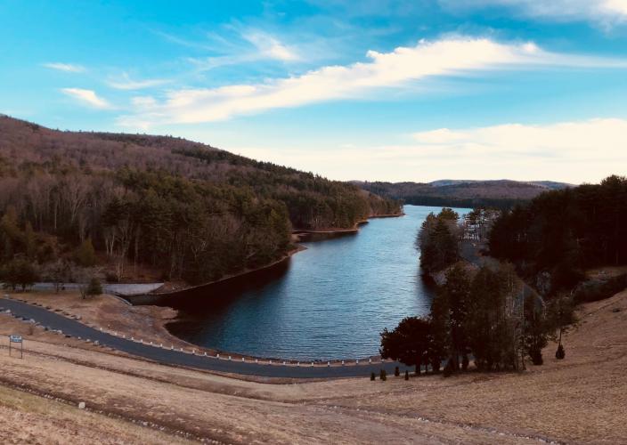
Coming north up Reservoir Rd the climb starts off reasonable enough with a scenic view of Lake McDonough. As you turn right onto Ratlum Rd (where the main strava segment begins) it kicks up sharply for a quarter mile averaging nearly 10%.

Relax (or keep cranking!) for the next half mile on a slightly downhill stretch as you pass Ski Sundown ski area on your right. It's back to business as the road narrows and winds uphill with a half mile at 10% including a tenth mile at over 14% (“stupidly steep” segment). Catch your breath with a flat stretch before sprinting up the shortest of the five stairs. After a brief flat it's up again with a now familiar quarter mile ~10% step.

At the top of the fourth step turn right onto Ratlum Mountain Rd and pick up all the speed you can get on a short downhill stretch as you come into "Satan's elbow". A devilish 0.4mi and the hardest part of the climb awaits as the road bends hard right and reaches grades in excess of 20%. The hill finally levels off a bit as you hit the peak.

For a fun descent continue straight and follow Wright Rd as it winds its way down to Cherry Brook Rd (route 179).