
51.4
PDI
27.3 mi
DISTANCE
8,326 ft
GAINED
5.7 %
AVG. GRADE
FULL CLIMB STATS
INTRO
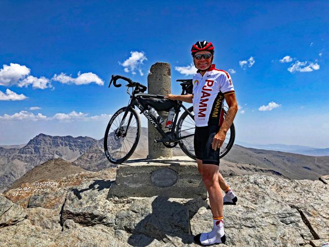
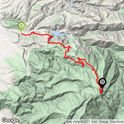
Pico Veleta is Europe's highest road, and this is the classic, most direct way up to it - starting right from the city of Granada near the Alhambra rather than from a trailhead outside town. This route covers 27.3 miles and 8,326 feet of climbing at an average grade of 5.7%, finishing at 10,605 feet just below the true summit at 11,148 feet (3,398m) - currently ranked 39th-hardest in our worldwide database.
This is the easier of our two Pico Veleta routes - see our separate Güéjar Sierra approach for a shorter, steeper alternative up the same mountain - but "easier" is relative on a climb this long.
You spend the first roughly 30 kilometers on the A-395 through the Sierra Nevada National Park gaining altitude steadily, passing the Pradollano ski resort before reaching the barrier at Hoya de la Mora (about 2,500m), where public vehicle traffic ends. Past the barrier, the road narrows, the pavement roughens, and the final kilometers to our finish average close to 8% at nearly 11,000 feet - a different climb from the miles that came before it.
While the Vuelta a España often features a summit finish here, they're disappointingly too scared to ride all the way to the top, usually ending at 2,500 meters, well short of the summit. But that's part of the appeal: this is a genuinely uncrowded, monumental climb that professional racing has decided is simply too high and too long to use.
PLAN YOUR ROUTE
 We've partnered with Sherpa-Map.com to bring you the best route planning tool. With a PRO Membership you can use this climb as a reference when creating your route.
 The 27.3-mile average of 5.7% understates how different the two halves of this climb feel. The first roughly 19 miles, from Granada through Pinos Genil or Cenes de la Vega to the barrier at Hoya de la Mora, are a steady, manageable grade in the 5-6% range on good pavement - this section carries most of the route's traffic and services.
Past the barrier, the character changes completely. Vehicle traffic ends, the road narrows, and the final kilometers to our finish average close to 8%, with rough, patched pavement giving way to broken asphalt and loose stone near the top. Save real energy for this section - it's short relative to the whole climb, but it's where the climb is actually earned.
Roadway: The lower roughly 30 kilometers, from Granada through the Sierra Nevada National Park to the Hoya de la Mora barrier, are on the A-395, a well-maintained two-lane highway. Past the barrier, the road has been closed to public vehicle traffic since 1989 due to environmental damage from the old summit road - it remains open to cyclists and pedestrians, but the surface deteriorates the higher you go, with rough, patched asphalt and sections of broken pavement and loose stone in the final kilometers.
Traffic: Expect real traffic on the lower A-395, especially near Granada and around the Pradollano ski resort turnoff - this is a working highway serving a ski area, not a quiet backroad. Past the Hoya de la Mora barrier, vehicle traffic disappears almost entirely since the road is closed to cars; you'll share it mainly with other cyclists and hikers.
Parking: There's no dedicated climb parking since the route starts in the city of Granada itself - park or start from your hotel in the city center near the Alhambra. If you'd rather drive partway up, El Dornajo (where the route joins the A-395) and the Hoya de la Mora barrier both have pull-offs and lots used by hikers and skiers.
You'll pass gas stations, cafes, and a few hotels on the lower A-395, with the last real services at Hoya de la Mora before the barrier - top off water and food there, because there's nothing beyond it. Wider tires (30-34mm) are worth running given the rough pavement in the closing kilometers.
This climb crosses every climate zone Granada has to offer: you can start in shirt-sleeves heat in the city and finish above 3,000 meters in genuinely cold, exposed, high-mountain conditions. Carry a packable jacket, full-finger gloves, and arm/knee warmers regardless of how hot it is at the bottom, and check the Sierra Nevada ski resort's live webcams for current snow conditions before committing to a summit attempt outside of peak summer.
Before heading out on any cycling adventure check out our Things to Bring on a Cycling Trip and use our interactive check list to ensure you don't forget anything.
Base yourself in Granada, a major city with full services and, of course, the Alhambra - easy to combine a rest day of sightseeing with this ride. Because the route starts in the city itself, there's no separate trailhead logistics to plan around.
Aim for June or September; midsummer heat in Granada is brutal for the lower kilometers, and the upper mountain can hold snow well into late spring or arrive early in fall, closing the road above the barrier even when the city below is warm.
If you'd rather tackle a shorter, steeper version of the same mountain, there's also a separate Güéjar Sierra approach to Pico Veleta - a different, harder route up the same peak.
ROUTE MAP
MEMBER RATING
CURRENT WEATHER
PJAMM TRIPS ADVENTURE STARTER BUNDLES
Check out PJAMM Adventure's prepackaged (self-guided) cycling trips. They will help you plan, document and conquer your next adventure.
NEARBY CLIMBS (0) RADIAL PROXIMITY
FROM No Climbs Found
MEMBER REVIEWS & COMMENTS
Let us know what you thought of this climb. Signup for our FREE membership to write a review or post a comment.
Already have an account?
LOG IN HERE
