
30.2
PDI
12.4 mi
DISTANCE
4,633 ft
GAINED
7 %
AVG. GRADE
FULL CLIMB STATS
Page Contributor(s): Frans Monchen, Gelderland, Netherlands
INTRO
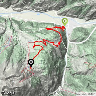
The Moosalp is a high alpine plateau above the Rhone Valley in Wallis, and the approach from Visp climbs 12.4 miles at a 7.0% average grade, gaining 4,633 feet to finish at 6,748 feet. It's one of two paved ways up - the other climbs from Stalden via Torbel on the far side - and both converge on the same high meadow.
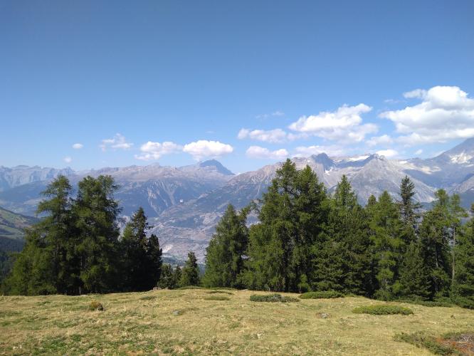
What makes the Moosalp worth the effort is the payoff at the top: from the plateau's high point, twelve peaks over 4,000 meters come into view, including the Mischabel massif's Dom and Taschhorn and the Weisshorn to the south, with the pyramid-shaped Bietschhorn dominating the skyline across the valley to the north. The lower slopes climb through vineyards and larch forest above Visp before opening into alpine pasture near the top.
The road is narrow and well-paved throughout, and it's popular enough with the local cycling community that the Moosalp region hosts an annual "Ride the Alps" cyclosportive each May drawing over 1,000 riders, though that event runs the Stalden-Torbel side rather than this one. Like most Alpine passes at this elevation, the road above Burchen closes each winter under snow and reopens in spring once conditions allow - typically by May.
PLAN YOUR ROUTE
 We've partnered with Sherpa-Map.com to bring you the best route planning tool. With a PRO Membership you can use this climb as a reference when creating your route.
 This climb averages 7.0% over its 12.4 miles, gaining 4,633 feet from 2,171 feet in Visp to a finish at 6,748 feet on the Moosalp plateau - a steady, sustained effort rather than a series of brutal ramps. The steepest full kilometer on the route touches roughly 11.0%, and the single steepest short pitch spikes to near 16.8%, but neither lasts long enough to define the character of the climb.
Most of the elevation is earned gradually through the middle miles, with the grade easing slightly in the final stretch as the road levels out across the high plateau toward the pass.
Roadway: Narrow, paved the entire way, and in good condition based on our research and recent rider reports. Like most high Alpine passes in this range, the upper road above Burchen is closed to traffic in winter under snow and reopens once conditions allow, typically by May - confirm current status before an early or late-season ride.
Traffic: Generally mild. The lower miles out of Visp see some local and valley traffic, but it thins out noticeably once the road starts climbing toward Burchen and the alpine pasture above.
Parking: At the climb start on Kantonstrasse in Visp - Map; Street View. Visp is a real working valley town with ample street parking near the base rather than a dedicated trailhead lot.
There are places to refuel on this one, which isn't a given at this altitude. Restaurant Dorbia, along the route above Burchen, and Restaurant Moosalp, right at the pass, both open for the cycling season and serve Wallis specialties - the Moosalp restaurant is known locally for raclette grilled over an open fire and a well-regarded mille-feuille. Don't count on either being open outside the main summer season, so carry water and food as a backup, especially on a shoulder-season ride.
Before heading out on any cycling adventure check out our Things to Bring on a Cycling Trip and use our interactive check list to ensure you don't forget anything.
Visp sits at the mouth of the Mattertal, the valley that leads up to Zermatt and the Matterhorn, so it's a natural base if you're combining this climb with other riding in the region. The Moosalp plateau itself is worth lingering on beyond the climb - it's a genuine high-altitude balcony, with hiking trails fanning out from the pass toward small alpine lakes and viewpoints over a dozen 4,000-metre summits.
If you're building a multi-day trip around this area, the neighboring Moosalp - Stalden approach climbs the same plateau from the opposite valley, making a natural loop with a car shuttle or a return by Postbus. Check current conditions at both the valley floor and the summit with our Weather tool before heading out, since the plateau can run noticeably colder and windier than Visp.
ROUTE MAP
MEMBER RATING
CURRENT WEATHER
PJAMM TRIPS ADVENTURE STARTER BUNDLES
Check out PJAMM Adventure's prepackaged (self-guided) cycling trips. They will help you plan, document and conquer your next adventure.
NEARBY CLIMBS (0) RADIAL PROXIMITY
FROM No Climbs Found
MEMBER REVIEWS & COMMENTS
Let us know what you thought of this climb. Signup for our FREE membership to write a review or post a comment.
Already have an account?
LOG IN HERE
