McKelligon Canyon Rd Bike Climb - PJAMM Cycling

1.4
FIETS
2.5 mi
DISTANCE
634 ft
GAINED
4.8 %
AVG. GRADE

FULL CLIMB STATS

Page Contributor(s): Dan Razum, Campbell, CA

INTRO

This 2.5 mile bike climb is located in TX, USA. The average gradient is 4.8% and there is a total elevation gain of 634 ft, finishing at 4,854 ft.

Use the profile tool, route map, and weather forecast to conquer this cycling climb.

See more details and tools regarding this climb's grade via our interactive Profile Tool.
Information Not Available

If you have any information regarding this climb, we'd like to hear from you. Click the CONTRIBUTE button to share your thoughts with us.

Information Not Available

If you have any information regarding this climb, we'd like to hear from you. Click the CONTRIBUTE button to share your thoughts with us.

Before heading out on any cycling adventure check out our Things to Bring on a Cycling Trip and use our interactive check list to ensure you don't forget anything.
Information Not Available

If you have any information regarding this climb, we'd like to hear from you. Click the CONTRIBUTE button to share your thoughts with us.

ROUTE MAP

MEMBER RATING

Not Yet Rated
-
Road
-
Traffic
-
Scenery

CURRENT WEATHER

PJAMM TRIPS ADVENTURE STARTER BUNDLES

Check out PJAMM Adventure's prepackaged (self-guided) cycling trips. They will help you plan, document and conquer your next adventure.
ALL TRIPS
Browse all of our prepackaged trips and find your next adventure!
Big Bend National Park
United States (TX)
12 ROUTES
36 POIs
ROUTE STATS (TOTAL)
458.4
mi
DISTANCE
30,275
ft
ELEV. GAIN

NEARBY CLIMBS (0) RADIAL PROXIMITY

FROM
No Climbs Found

MEMBER REVIEWS & COMMENTS

Let us know what you thought of this climb. Signup for our FREE membership to write a review or post a comment.
Already have an account?
ROUTE MAP
PROFILE TOOL
Route Data
S.G. (%)
hide
Segment Data
hide

Climb Profile Not Found
CLIMB SUMMARY

Cycling Sugarloaf Mountain, Franklin Mountain State Park, El Paso

Ride 2.5 miles gaining 626’ at 4.7% average grade (5.2% climb only)

Climb summary by PJAMM Ambasador Dan Razum.


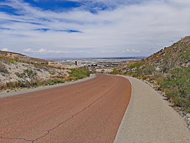
We start the climb off with a short little steep section, about 10% or so, but not too long, maybe a quarter of a mile.  After this part the gradient isn't too hard the rest of the way.  So you could view the beginning as a warm up, in case the weather isn't quite hot enough to warm you up!

The road is in good condition, it is wide and it has a nice shoulder.  This seems to be a popular route for both cyclists and runners.  We are riding in McKelligon Canyon Park and the road is basically a dead end so traffic is not a concern.  There isn't any shade along the route so it can get hot, depending on the time of day.  But no surprise, we are in the high desert, after all.

The end of the road is a small loop with several pavillions and picnic tables for day use. There  is also Ranger Station but it was closed on the Sunday when we were there.  We didn't see any water at the top, but there is a gas station and convenience store the beginning of the climb and we made good use of that on the way back down to load up on refreshments to beat the heat.

Access to full Climb Summary requires a PJAMM Cycling PRO Membership!

It takes less than a minute to sign up & with your PRO membership you can:
  • Rate climbs, post comments and share your experiences on any of our climb pages
  • Create bucket lists of climbs & mark the dates you complete them
  • Weather data for all climbs - Start & Finish
  • Upload photos to your member page to customize your PJAMM Cycling experience
  • Utilize all of our interactive tools - Profile & Routes in Area
  • Download climb route .gpx files
LEARN MORE
SIGN UP

Already have an account? LOG IN HERE