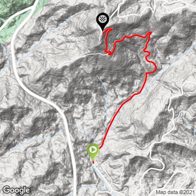
Panther Mountain Bike Climb - PJAMM Cycling

6.4
FIETS
2.8 mi
DISTANCE
1,761 ft
GAINED
11.9 %
AVG. GRADE

FULL CLIMB STATS

Page Contributor(s): Dan Razum, San Jose, CA

INTRO

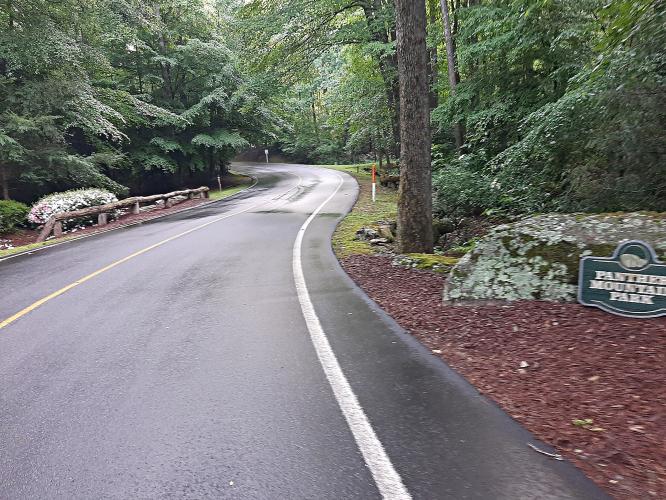
Located in the Blue Ridge Mountains, Panther Mountains this climb is a legitimate beast!

See more details and tools regarding this climb's grade via our interactive Profile Tool.
Information Not Available

If you have any information regarding this climb, we'd like to hear from you. Click the CONTRIBUTE button to share your thoughts with us.

Information Not Available

If you have any information regarding this climb, we'd like to hear from you. Click the CONTRIBUTE button to share your thoughts with us.

Before heading out on any cycling adventure check out our Things to Bring on a Cycling Trip and use our interactive check list to ensure you don't forget anything.
Information Not Available

If you have any information regarding this climb, we'd like to hear from you. Click the CONTRIBUTE button to share your thoughts with us.

ROUTE MAP

MEMBER RATING

Difficulty: Strenuous
5
Road
5
Traffic
2
Scenery

CURRENT WEATHER

PJAMM TRIPS ADVENTURE STARTER BUNDLES

Check out PJAMM Adventure's prepackaged (self-guided) cycling trips. They will help you plan, document and conquer your next adventure.
ALL TRIPS
Browse all of our prepackaged trips and find your next adventure!

NEARBY CLIMBS (0) RADIAL PROXIMITY

FROM
No Climbs Found

MEMBER REVIEWS & COMMENTS

Let us know what you thought of this climb. Signup for our FREE membership to write a review or post a comment.
Already have an account?

Jul 13, 2023
difficulty: Strenuous
scenery: 2
traffic: 5
road: 5
Jul 13, 2023
scenery: 2
traffic: 5
road: 5
June 17, 2023 A wonderful, very steep climb on an excellent road with no traffic. Per the "full review", this climb is on a private road but you can enter from Torre Creek Rd. I parked at the Torre Creek Church / cemetery. No issues. This climb switchbacks it's way up the mountain and although it's very steep, it does back off enough numerous times to catch your breath and squeeze a drink. No views but nice Appalachians alpine woods. Lots more climbing throughout the subdivision. My garmin showed 31% on Sun Breeze Rd. I did this climb same day as Sassafras Mountain. Both nearby with a nice, easy drive. Camped at Table Rock SP - which also has some fun, short, steep climbs.
Jun 25, 2022
Jun 25, 2022
difficulty: Challenging
scenery: 2
traffic: 5
road: 5
Jun 25, 2022
scenery: 2
traffic: 5
road: 5
It is within the private neighborhood of Cliffs Valley.
ROUTE MAP
PROFILE TOOL
Route Data
S.G. (%)
hide
Segment Data
hide

Climb Profile Not Found
CLIMB SUMMARY

Cycling Panther Mountain

Ride 2.8 miles gaining 1,761’ at 11.9% average grade (14% climb only).

Climb summary by PJAMM ambassador Dan Razum.

The climb starts within a large gated community.  The main entrance to the community is off of highway 25, but we did not enter that way so we don’t know if there is easy pubic access or not.  It is a large community, with a golf course, parks and other amenities, so we assume it is possible to drive in through the main gate, but we did not confirm. Instead, we parked off of Old Highway 25 and biked in through Terry Creek Road.  There is an unmanned gate at the Terry Creek Road entrance to the community, which requires an access code to drive through, but it is easy to navigate on a bike.  There were no signs saying "no entrance", "no bikes" or anything similar, so we rode through and didn't encounter

any problems.


The climb starts shallow and straight but that doesn't last long.  Pretty quickly the gradient gets steep and then it gets really steep and the curves get sharp. There is plenty of shade along the way, so at least there is that, but you better not forget your climbing gears on this one!

The steepest quarter mile is 19% and steepest ½ mile 18%.

We pass many houses along the way, with nice landscaping and the road is well maintained, the surface is smooth.  There is a shoulder at the beginning but it disappears as soon as the  gradient gets steep. Traffic was light and courteous so we didn't have any safety concerns.

There aren't any views on this climb, unfortunately, due to all the trees. The top is unmarked but it is at a stop sign and fairly obvious.

End of the climb.

Access to full Climb Summary requires a PJAMM Cycling PRO Membership!

It takes less than a minute to sign up & with your PRO membership you can:
  • Rate climbs, post comments and share your experiences on any of our climb pages
  • Create bucket lists of climbs & mark the dates you complete them
  • Weather data for all climbs - Start & Finish
  • Upload photos to your member page to customize your PJAMM Cycling experience
  • Utilize all of our interactive tools - Profile & Routes in Area
  • Download climb route .gpx files
LEARN MORE
SIGN UP

Already have an account? LOG IN HERE