![]()
The highest and most remote road in the U.S.
Dalton Highway continues north to the Arctic Ocean.
![]()
Summary by PJAMM Ambassador Bryant Robbins (2021)
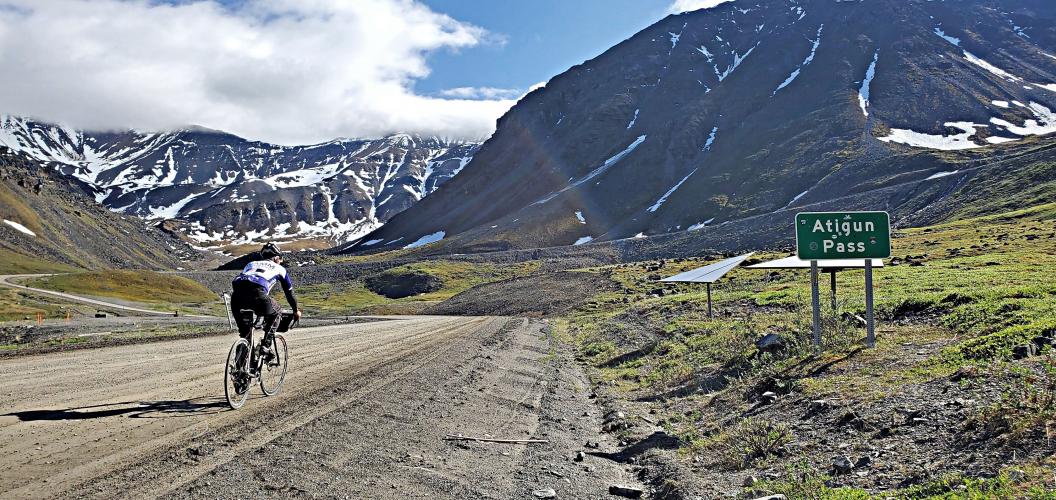
Atigun Pass is the highest pass in Alaska. It is located on the Dalton Highway aka the Haul Road. The Dalton is 75% gravel, and the pass is entirely gravel. The Milepost calls the Haul Road the most remote and dangerous road in Alaska. Atigun Pass is located 131 road miles north of the Arctic Circle, and about 175 road miles south of the Arctic Ocean. It is 325 miles from the nearest town Fairbanks, 684 miles from Anchorage, 904 miles from Homer Alaska, and 1021 road miles from Skagway Alaska. Deadhorse/Prudhoe Bay, the oil camp on the Arctic coast, is 175 miles away, but has no permanent population. A couple of brave souls have lived there year-round, but all eventually leave. Alaskans refer to anywhere other than Alaska as “outside” and Atigun Pass at 68 degrees north latitude is a long way from anywhere “outside.”
![]()
The Brooks Range, where Atigun Pass crosses it, forms the continental divide separating the North Slope, Artic Ocean drainage, from the South Slope, Bering Sea drainage. As an interesting side note, the North Slope only receives about 5 inches of precipitation per year, about half what Phoenix receives. But don’t expect nice weather or easy walking across the tundra. The permafrost keeps water from soaking into the ground causing swampy conditions and the tussocks make walking almost impossible. The Haul Road was originally constructed to haul material for the building of the Alaska Pipeline. Now it is used to haul supplies to the oil fields located on the Arctic Ocean so you will see some semi-truck traffic on the road.
The fact that the Dalton is mostly gravel makes it impossible to reach the pass in a rental vehicle without violating the rental agreement. In many cases, the sections of the road that are paved are worse than the gravel sections due to frost heaves and crumbling pavement that the Alaska Department of Transportation cannot keep up with. The nearest food or lodging is located 76 miles south in Coldfoot Camp. Therefore, as should be no surprise when considering the most remote climb in the world, one of the biggest challenges in doing the climb is simply getting there.
![]()
Once you do get there, you may encounter, in the space of a couple of days (as we did), 50 mph winds, very cold temperatures even in summer, rain, sun, fog with zero visibility, steep grades, grizzly bears, and an impressive variety of biting, buzzing insects. If that sounds like paradise, well, in some ways it is. The scenery is stunning, and there is something indescribable about experiencing this thin ribbon of civilization in such a vast wilderness. The midnight sun makes it possible to ride at any hour, day or night. You leave the trees behind on the south approach to the pass - the last one at the base of the Chandler Shelf. From that point north, there is only tundra all the way to the Arctic Ocean. Along the way you are likely to see caribou and musk ox. While not one of the giants of the world, the pass does still pack a punch, even assuming you get a nice weather window, with grades topping out above 15% on both sides of the mountain.
![]()
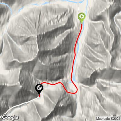
Assuming you aren’t doing a bike tour from the Arctic Ocean to Patagonia, which is a bucket list trip for the most adventurous bike tourists, and assuming that you have a vehicle that you can drive up the Dalton, camping is a good option for accessing the pass. On the south side there are several pullouts with beautiful scenery, some streamside. On the north side, there is a huge level parking lot with an old, abandoned fire house near the base of the pass that makes an excellent camp spot. We rode downhill from there to begin the climb at the “Atigun River 1” crossing. Another option might be to hire a shuttle from Fairbanks or Prudhoe Bay and arrange for drop-off and pickup. There is currently commercial jet service into Prudhoe Bay from Anchorage.
![]()
It is worth noting, in case of emergency, that some of the pump stations on the North Slope now have excellent cell service. Pump station 3 is the closest to the pass. This is apparently a very recent development (summer 2021) since we haven’t seen it mentioned in any of the guides.
Unfortunately, there is no sign at the top of the tallest pass in Alaska for you to stand in front of for a photograph. There are signs at the bottom of the pass but none at the top. Perhaps this is because the plows knock them over. Perhaps it’s because, as is so often said in Alaska, “we don’t care how they do it outside.”