
30.3
PDI
6 mi
DISTANCE
3,400 ft
GAINED
10.9 %
AVG. GRADE
FULL CLIMB STATS
INTRO
PLAN YOUR ROUTE
 We've partnered with Sherpa-Map.com to bring you the best route planning tool. With a PRO Membership you can use this climb as a reference when creating your route.
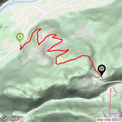
 This climb averages 10.8% over 6.0 miles, gaining 3,400 ft - a consistently steep grind with almost no easy sections. The first roughly 5 miles out of Haiming sit at or above 10% nearly the entire way, without the long flat or gentle stretches that break up many Alpine climbs. The final push to the Sattele summit at 1,690 m eases only slightly before the road tips over and begins its descent toward Ochsengarten.
Roadway: Paved and well-maintained, though narrow with frequent curves - a proper mountain road rather than a wide touring route. Surface quality has been reported as good and orderly by regular riders of this climb.
Traffic: Light. This is a quiet local road rather than a resort access route, and it's popular specifically because it avoids the heavier motor traffic found on the main Kühtai pass road nearby. Watch for cows and horses on the road near the summit, especially in summer grazing season.
Parking: Haiming is a village in the Inn Valley with street parking available near the base of the Haimingerbergstraße; the village also sits on the Ötztal cycling path and a regional bus route (line 4196) connecting Imst, Haiming, Silz, Oetz, and Ochsengarten, if you're arranging transport without a car.
Come with a compact or sub-compact crank and a wide-range cassette - a 10.8% average with most of the climb sitting at double digits will punish standard gearing quickly. There's nothing along the route itself, so fill bottles and eat in Haiming before you start; this is a short enough climb that you likely won't need to carry more than one bottle's worth of water, but the sustained steep grade means you'll burn through it faster than the distance alone suggests.
Before heading out on any cycling adventure check out our Things to Bring on a Cycling Trip and use our interactive check list to ensure you don't forget anything.
Haiming and the neighboring town of Silz, both in the Inn Valley along the Ötztal cycling path, are practical bases with hotels and restaurants and easy access to the Ötztal's much larger menu of climbs. This particular ascent is a favorite training route for cyclists preparing for the Ötztaler Radmarathon, one of Europe's toughest cyclosportives, which passes nearby over the Kühtai.
If you're building a bigger day, the descent toward Ochsengarten connects directly to the road up to Kühtai itself, and there's a second, gentler way up to this same summit from Oetz on the other side of the mountain - worth exploring with our Routes in the Area tool if you want to compare both approaches to the Sattele.
ROUTE MAP
MEMBER RATING
CURRENT WEATHER
PJAMM TRIPS ADVENTURE STARTER BUNDLES
Check out PJAMM Adventure's prepackaged (self-guided) cycling trips. They will help you plan, document and conquer your next adventure.
NEARBY CLIMBS (0) RADIAL PROXIMITY
FROM No Climbs Found
MEMBER REVIEWS & COMMENTS
Let us know what you thought of this climb. Signup for our FREE membership to write a review or post a comment.
Already have an account?
LOG IN HERE
