
24.5
PDI
8.3 mi
DISTANCE
3,462 ft
GAINED
7.9 %
AVG. GRADE
FULL CLIMB STATS
INTRO
PLAN YOUR ROUTE
 We've partnered with Sherpa-Map.com to bring you the best route planning tool. With a PRO Membership you can use this climb as a reference when creating your route.
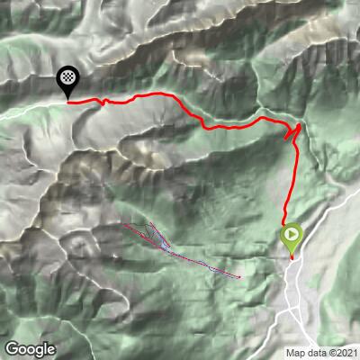
 This climb gains 1,055 m (3,462 ft) over 13.4 km (8.3 mi) at an average grade of 7.9%. The steepest quarter-mile averages 12.0%, and the steepest mile 11.5% - both concentrated in the climb's middle section, where grades on this pass road reportedly reach as high as 18.9% in short ramps.
The first steep test comes almost immediately: a roughly 250 m (820 ft) pitch near 13% within Imst's town limits, before the road settles into its long alpine grind toward the pass.
Roadway: The road (L266) is narrow but well paved throughout, winding through numerous switchbacks as it climbs from forest into open alpine terrain. It's closed to vehicles over 14 metric tons and to all traffic outside the warm-weather season - generally November through April - and can also close temporarily in-season: an automatic radio-controlled system installed in 2004 shuts the road at the first sign of avalanche, rockfall, or mudslide activity, all of which occur here. Check current conditions before you go.
Traffic: Light to moderate, and it includes a meaningful number of motorcyclists, who use this pass as a well-known scenic shortcut between the Inn and Lech valleys. Some sections are narrow enough that care is needed on blind bends.
Parking: Imst has full town services and roadside/lot parking near the western edge of town where the Hahntennjochstrasse begins; fuel up and stock up here, since there's little beyond small hamlets until you're over the pass.
Bring mountain gearing - a compact setup with a 34-tooth small chainring and a 30-32-tooth largest rear cog is a sensible baseline given the sustained double-digit pitches in the middle section, plus the 13% ramp right out of Imst.
Because the summit sits close to 1,900 m (6,200 ft), temperatures at the top can be dramatically cooler and windier than in the Inn Valley below - pack a layer for the descent even on a warm day.
Before heading out on any cycling adventure check out our Things to Bring on a Cycling Trip and use our interactive check list to ensure you don't forget anything.
Imst makes a good base, with full services and easy access to several other Tirol passes. The Lech Valley side of Hahntennjoch, from Elmen, is a separate PJAMM climb with its own character - a legitimate way to sample both approaches to the same pass if you're spending more than a day in the area.
Our Routes in the Area tool can help you find other climbs nearby and plan a route connecting them.
ROUTE MAP
MEMBER RATING
CURRENT WEATHER
PJAMM TRIPS ADVENTURE STARTER BUNDLES
Check out PJAMM Adventure's prepackaged (self-guided) cycling trips. They will help you plan, document and conquer your next adventure.
NEARBY CLIMBS (0) RADIAL PROXIMITY
FROM No Climbs Found
MEMBER REVIEWS & COMMENTS
Let us know what you thought of this climb. Signup for our FREE membership to write a review or post a comment.
Already have an account?
LOG IN HERE
