![]()
Cycling Magdalena Peak
Ride 5.7 miles gaining 1,839’ at 5.8% average grade (7.1% climb only)
Magdalena Peak is in the Sierra de las Uvas (Grape Mountains) mountain range and the climb is partially within the Organ Mountains–Desert Peaks National Monument (established 2014; 496,330 acres).
![]()
The radar facility at the finish of our climb is operated by the Federal Aviation Administration.
Climb report by PJAMM ambassador Dan Razum, Campbell, CA.
We have to start out with a disclaimer for this ride: There is a section of this climb that has a gate and we aren't sure if it is legal to ride all the way to the top. The sign on the gate says the facility is used in FAA Air Traffic Control and damages or trespasses will be prosecuted under Federal law. So the disclaimer is to ride at your own risk. However, having stated the
disclaimer, we believe that the sign refers to the facility at the top of the climb and that the climb itself is not Federal land and it is gated to prevent cars from driving it, due to the steep grade. But this is only our belief, our understanding may not be correct. Anyway, it is easy enough to walk around the gate as a cyclist or a hiker but it isn't possible to drive around the gate.
We did this climb on a Sunday morning and did not encounter anybody along the climb or at the top, but that may have been because it was a weekend. So we need to stress again that we are not sure about the legality of this climb, proceed at your own risk - we only report, not endorse this climb.
The climb starts on the valley floor and we quickly come to a steep section. This climb seems to vary between nearly flat and quite steep, there isn't much shallow gradient, it's either fairly easy or pretty hard.
![]()
After the first steep section we go over a cattle guard grate and there is a breather and a short downhill before we start climbing again.
![]()
We climb a short steep section and get another breather and then we arrive at the gate.
![]()
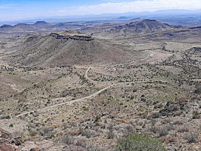
From the gate we can see where the road goes up the mountain and it looks pretty steep. After the gate, the real climbing begins. It is steep up to the first hairpin turn and then it gets really steep. And of course there isn't any shade, nowhere to escape the sun beating down.
![]()
We just have to grind it out for the next mile. After we finally get up to the top of the mountain then the last mile is fairly easy, we ride along the ridge to the FAA facility.
![]()
![]()
![]()
At the end of the climb you can walk a short distance from the road to the cliff and get some spectacular views of the surrounding valleys and mountains. There are actually nice views along the entire really steep section, you can see the road and valley below and that's a good excuse to take a break in the middle of the climb, to admire the view.
![]()
There are no provisions along this climb. It isn't a long climb but it is steep and hot so don't skimp on carrying water. The pavement is generally in good condition, although there are a few potholes along the way. The road is narrow but you aren't likely to encounter any vehicles, especially after the gate, so traffic is not a concern.

 We've partnered with Sherpa-Map.com to bring you the best route planning tool. With a PRO Membership you can use this climb as a reference when creating your route.

