
29.3
PDI
11.6 mi
DISTANCE
4,425 ft
GAINED
7.2 %
AVG. GRADE
FULL CLIMB STATS
INTRO
PLAN YOUR ROUTE
 We've partnered with Sherpa-Map.com to bring you the best route planning tool. With a PRO Membership you can use this climb as a reference when creating your route.
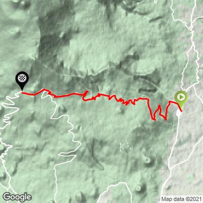
 This climb averages 7.2% over 18.6 km (11.6 mi), with a hard, honest character rather than one brutal pitch followed by easy miles. The steepest 100 yards, right at the start past Zafferana's amphitheater, hits 15.4%, and the steepest quarter mile averages 11.7%. From there the grade settles but stays demanding: the steepest half mile averages 10.3%, the steepest mile 9.7%, the steepest 2 km 9.5%, and even the steepest 5 km still averages 8.1%. There's no real flat or descending section to recover on - total descent along the entire route is just 12 m (38 ft) - so the effort is sustained essentially the whole way from Zafferana's 573 m (1,880 ft) start to the 1,910 m (6,267 ft) finish at Rifugio Sapienza.
Roadway: The SP92 is paved the entire way and in excellent condition - wide, smooth, and cut with consistently well-radiused hairpins, widely regarded as one of the best-surfaced roads on the mountain. Etna remains an active volcano with an ongoing eruptive phase through 2026 that has mostly affected the summit craters; the paved route to Rifugio Sapienza has generally stayed open through this activity, but access can be restricted on short notice during intense eruptive episodes. Check current conditions with INGV's Etna Observatory (ct.ingv.it) before you go.
Traffic: Light to moderate. The climb starts in Zafferana's town streets, then quickly thins to light local traffic through the pine forest; expect more cars and tour buses in the final few kilometers near Rifugio Sapienza, a major tourist stop with a cable car to the crater area.
Parking: Zafferana Etnea has ample roadside parking around its town center, close to where the SP92 climb begins. There's no need to arrange parking at the top - Rifugio Sapienza has a large lot serving its restaurants, shops, and cable car station.
Zafferana has full services - cafes, restaurants, and shops - right at the base before you start. Above town there's nothing until Rifugio Sapienza at the top, which has restaurants, bars, and a shop, so carry what you need for the climb itself. The finish sits at 1,910 m (6,267 ft), and temperatures and wind up there can be sharply different from Zafferana's mild coastal-facing slopes even in summer - pack a real layer for the descent. Given the sustained 7-9% grades with no real recovery section, a compact or wide-range gearing setup is worth having.
Before heading out on any cycling adventure check out our Things to Bring on a Cycling Trip and use our interactive check list to ensure you don't forget anything.
Zafferana Etnea is worth a slow visit before or after the ride - it's known across Sicily for its honey, produced from the volcano's rich flora, with its own honey museum and an October Sagra del Miele (Honey Festival) as part of the town's month-long Ottobrata Zafferanese, when each Sunday is dedicated to a different local harvest (grapes, honey, mushrooms and chestnuts, then apples). The town's Anfiteatro Falcone e Borsellino, right along the climb's opening stretch, hosts concerts through the summer.
This is one of several ways up Mount Etna, each starting from a different town on the mountain's flanks - see our other Etna climb pages for the longer route from Catania and the steep eastern approach through San Giovanni Montebello and Milo. Given how much conditions can shift on an active volcano, our Weather tool is worth checking before you commit to the ride.
ROUTE MAP
MEMBER RATING
CURRENT WEATHER
PJAMM TRIPS ADVENTURE STARTER BUNDLES
Check out PJAMM Adventure's prepackaged (self-guided) cycling trips. They will help you plan, document and conquer your next adventure.
NEARBY CLIMBS (0) RADIAL PROXIMITY
FROM No Climbs Found
MEMBER REVIEWS & COMMENTS
Let us know what you thought of this climb. Signup for our FREE membership to write a review or post a comment.
Already have an account?
LOG IN HERE
