25.3
PDI
11.1 mi
DISTANCE
4,019 ft
GAINED
6.7 %
AVG. GRADE
FULL CLIMB STATS
INTRO
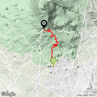
This 11.1 mile bike climb is located in Sicilia, Italy. The average gradient is 6.7% and there is a total elevation gain of 4,019 ft, finishing at 6,296 ft.
Use the profile tool, route map, and weather forecast to conquer this cycling climb.
Use the profile tool, route map, and weather forecast to conquer this cycling climb.
PLAN YOUR ROUTE
This climb averages 0%. The steepest quarter mile of this climb is 0%. NaN miles of the climb is at or above 10% grade. The gradient on this climb is broken down as follows:
See more details and tools regarding this climb's grade via our interactive Profile Tool.
See more details and tools regarding this climb's grade via our interactive Profile Tool.
Information Not Available
If you have any information regarding this climb, we'd like to hear from you. Click the CONTRIBUTE button to share your thoughts with us.
Information Not Available
If you have any information regarding this climb, we'd like to hear from you. Click the CONTRIBUTE button to share your thoughts with us.
Before heading out on any cycling adventure check out our Things to Bring on a Cycling Trip and use our interactive check list to ensure you don't forget anything.
Information Not Available
If you have any information regarding this climb, we'd like to hear from you. Click the CONTRIBUTE button to share your thoughts with us.
ROUTE MAP
MEMBER RATING
CURRENT WEATHER
PJAMM TRIPS ADVENTURE STARTER BUNDLES
Check out PJAMM Adventure's prepackaged (self-guided) cycling trips. They will help you plan, document and conquer your next adventure.
NEARBY CLIMBS (0) RADIAL PROXIMITY
FROM No Climbs Found
MEMBER REVIEWS & COMMENTS
Let us know what you thought of this climb. Signup for our FREE membership to write a review or post a comment.
Already have an account?
LOG IN HERE
golmstead


This is probably the easiest of the 3 or 4 approaches to Mont Ventoux. I admit to chickening out when offered the traditional approach. The climb from Sault to Chalet Reynard was really nice. We rode through the forest and it wasn't too hard at all. When we got to Chalet Reynard we joined the traditional approach to the summit. There's not a lot to see on this stretch of road. It's a lot like Alpe d'Huez in that it's filled with people like me, people who are check off a bucket list climb. Once I got my photo we descended back to Sault, then continued descending through a beautiful canyon on road D942 to Villes-sur-Auzon for lunch. The road from Sault to Villes-su-Auzon is about 30 miles of gentle descending through the most amazing canyon I think I've ever see. You barely need to touch you brakes the whole time. Just take it all in. A great day on the bike.