10.1
PDI
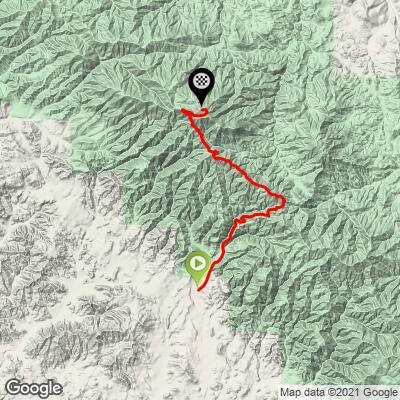
7.2 mi
DISTANCE
2,038 ft
GAINED
4.7 %
AVG. GRADE
FULL CLIMB STATS
Page Contributor(s): Joel Blatt, Bend, OR
INTRO
PLAN YOUR ROUTE
This climb averages 0%. The steepest quarter mile of this climb is 0%. NaN miles of the climb is at or above 10% grade. The gradient on this climb is broken down as follows:
See more details and tools regarding this climb's grade via our interactive Profile Tool.
See more details and tools regarding this climb's grade via our interactive Profile Tool.
Information Not Available
If you have any information regarding this climb, we'd like to hear from you. Click the CONTRIBUTE button to share your thoughts with us.
Information Not Available
If you have any information regarding this climb, we'd like to hear from you. Click the CONTRIBUTE button to share your thoughts with us.
Before heading out on any cycling adventure check out our Things to Bring on a Cycling Trip and use our interactive check list to ensure you don't forget anything.
Information Not Available
If you have any information regarding this climb, we'd like to hear from you. Click the CONTRIBUTE button to share your thoughts with us.
ROUTE MAP
MEMBER RATING
CURRENT WEATHER
PJAMM TRIPS ADVENTURE STARTER BUNDLES
Check out PJAMM Adventure's prepackaged (self-guided) cycling trips. They will help you plan, document and conquer your next adventure.
NEARBY CLIMBS (0) RADIAL PROXIMITY
FROM No Climbs Found
MEMBER REVIEWS & COMMENTS
Let us know what you thought of this climb. Signup for our FREE membership to write a review or post a comment.
Already have an account?
LOG IN HERE
brnwdv
Really fun and remote feeling climb. Closed to cars and only a few campsites and ATV/Moto users nearby. As of May 2023 the road had many and constant patches of dirt of varying annoyance, but it is not too bad and the entire thing is paved. It does mean caution is needed on the many descents of this undulating climb with many quick up and downs.
After a more peaceful section up a canyon and up to views of the Pozo valley below, the road reaches a pass, with the paved climb jutting off to the left and starting en epic section along a ridge leading to the summit. Views of the eastern valleys reveal themselves and then the solid block of Black Mountain comes into view face on and intimidating. This fun section undulates frequently and goes through many sharp turns before eventually descending a few hundred feet and the final climb begins up to the summit. I'd say this is a hidden gem!
joelmblatt
Climb is challenging, but offers spectacular views. Black Mountain Road off Park Hill via Pozo or Las Pilitas. Seven miles to FAA radar station with gradients hitting 20%+, but undulates for respites. Near top, may have to “bandit†gate. Not well-known, but I highly recommend.