
24.3
PDI
7.6 mi
DISTANCE
3,353 ft
GAINED
8.4 %
AVG. GRADE
FULL CLIMB STATS
INTRO
Rossfeld South is the Obersalzberg approach to the Rossfeld Panoramastraße (Roßfeldhöhenringstraße), the tolled Alpine road that crosses the Rossfeld ridge above Berchtesgaden and tops out as Germany's highest through-road. From Unterau the route climbs 12.2 km (7.6 mi) and gains 1,022 m (3,353 ft) at an 8.4% average grade, finishing at 1,543 m (5,062 ft) near the Ahornbüchsenkopf, the high point of the Rossfeld.
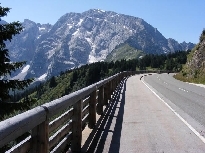
It shares its opening kilometers with Rossfeld North, then stays on the B 319 at Oberau and climbs to the Klaushöhe on the Obersalzberg, where the south toll ramp - the Purtschellerstraße - begins. Cyclists ride the toll road free. From the Mautstelle Süd the road winds past the Ofnerboden, the Eckersattel and the Enzianhütte toward the Ahornalm, running directly beneath the pale limestone north face of the Hoher Göll (2,522 m), with the Kehlsteinhaus perched on the ridge between the Kehlstein and the Göll. The sharpest bend on the whole road, the Regerkurve between the lower and upper Ahornalm, is followed immediately by its steepest pitch - a fitting sting in the tail.
Beyond the cycling, the Rossfeld road is a favorite film set: scenes for The Sound of Music (released in Germany as "Meine Lieder - meine Träume") and Indiana Jones and the Last Crusade were shot here. For the road's WWII-era origins and hillclimb racing history, see our Rossfeld North page.
PLAN YOUR ROUTE
 We've partnered with Sherpa-Map.com to bring you the best route planning tool. With a PRO Membership you can use this climb as a reference when creating your route.
 Rossfeld South climbs 12.2 km (7.6 mi) and gains 1,022 m (3,353 ft) at an 8.4% average grade, from 528 m (1,733 ft) in Unterau to 1,543 m (5,062 ft) near the Ahornbüchsenkopf.
The climb opens with a stiff kick out of Unterau, then settles into mostly 5-9% kilometers through Oberau and up the B 319 to the Klaushöhe, with a couple of easier stretches to recover. The toll road is where it bites: the steepest 2 km average 11.0% and the steepest kilometer 12.4%, both in the upper half as the road climbs from the Eckersattel past the Regerkurve. The steepest 500 meters average 14.4%, and short ramps top 20%.
Roadway: Paved the entire way. The lower half uses the public B 319 through Oberau to the Klaushöhe; from there the Purtschellerstraße is part of the privately operated Rossfeld Panoramastraße, whose toll revenue funds upkeep that the operator puts at two to three times the cost of a typical valley highway - and it shows in the surface. The toll road is open year-round, and cyclists ride it free (cars paid €9.50 at the Mautstelle Süd in 2026). Check rossfeldpanoramastrasse.de before you go for any short maintenance closures.
Traffic: The B 319 is the main public road onto the Obersalzberg, so expect steady car, coach and motorcycle traffic from Oberau up to the Klaushöhe, especially in summer and during school holidays. Past the south toll station the road quiets down considerably, though motorcycles are common on fine weekends - ride early or midweek for the calmest climb.
Parking: This climb shares its Unterau start with Rossfeld North, where there's no dedicated lot - park considerately in Unterau or ride out from Berchtesgaden. If a support driver is meeting you (cars pay the toll), the south ramp has the Parkplatz Enzianhütte partway up, and the Ahornkaser has its own parking at 1,521 m right beside the finish.
Provisions: There's nothing on the way up, so stock up in Berchtesgaden. At the top, the Ahornkaser - billed as Germany's highest mountain restaurant reachable by car - sits right beside the finish and is open year-round, though it has regular closing days and occasional private events, so check its website before counting on it. The Rossfeld Skihütte and the Rossfeld Kiosk, a little farther along the ridge road, are the other options.
Gear: Bring low gearing: the steepest kilometer averages 12.4% and short ramps pass 20%, most of it in the last few kilometers when your legs are already tired. The finish sits on an exposed ridge more than 1,000 m above the valley, so a wind layer for the descent is worth the pocket space even on a warm day.
Before heading out on any cycling adventure check out our Things to Bring on a Cycling Trip and use our interactive check list to ensure you don't forget anything.
The Ahornkaser is the natural place to end this ride. Run by the Walser-Ertl family since 2023, the inn sits where the south ramp meets the ridge-top Scheitelstrecke, with three dining rooms, a big terrace facing the Hoher Göll and, in summer, a balcony looking back down on Berchtesgaden. It also hosts occasional sundowner evenings in good summer weather.
If you have legs left for a walk, the Purtscheller-Haus (1,692 m), the traditional base for climbs of the Hoher Göll, is about 1 hour 15 minutes on foot from the Ahornkaser via the Eckersattel. Bikes stay behind - it's a hiking trail.
To make a loop, continue along the Scheitelstrecke (partly on Austrian soil) and descend the north ramp to Oberau - the reverse of our Rossfeld North climb. The Kehlsteinhaus (Eagle's Nest) you see from the south ramp has its own page too.
Conditions on the Rossfeld ridge can differ sharply from the valley floor - check current conditions before you go with our Weather tool.
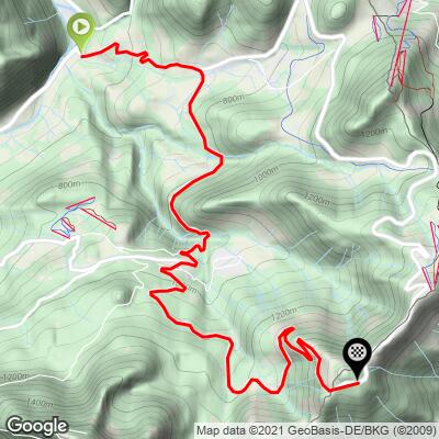
ROUTE MAP
MEMBER RATING
CURRENT WEATHER
PJAMM TRIPS ADVENTURE STARTER BUNDLES
Check out PJAMM Adventure's prepackaged (self-guided) cycling trips. They will help you plan, document and conquer your next adventure.
NEARBY CLIMBS (0) RADIAL PROXIMITY
FROM No Climbs Found
MEMBER REVIEWS & COMMENTS
Let us know what you thought of this climb. Signup for our FREE membership to write a review or post a comment.
Already have an account?
LOG IN HERE
