
25.8
PDI
6.7 mi
DISTANCE
3,292 ft
GAINED
9.3 %
AVG. GRADE
FULL CLIMB STATS
INTRO
Rossfeld North is the northern approach to the Roßfeldhöhenringstraße (Rossfeld Panoramastraße), a legendary Alpine toll road linking Berchtesgaden with the Austrian border above Salzburg. From Unterau, a district of Berchtesgaden, the route climbs 10.8 km (6.7 mi), gaining 1,003 m (3,292 ft) at a 9.3% average grade through Oberau to the road's north toll station, then continues along the ridge to a summit at 1,532 m (5,025 ft) - one of the highest paved through-roads in Germany.
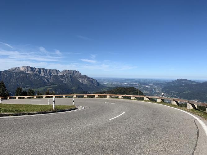
It's a private toll road, but cyclists cross for free via a dedicated bypass lane, so despite roughly 100,000 vehicles a year on the road, the climb sees a fraction of the traffic of a comparable public Alpine pass. Six hairpins break up a steep first two-thirds before the grade eases near the summit ridge, and the payoff is one of the best panoramas in the Bavarian Alps - the Salzach Valley and Salzburg below, with the Untersberg, Hoher Göll and Watzmann massifs filling the skyline.
Built in stages starting in 1937 as the easternmost leg of the never-completed Deutsche Alpenstraße (German Alpine Road), it stalled during WWII and wasn't finished until 1955, and remains a regular hillclimb race venue - the Rossfeldrennen and Edelweiss Bergpreis both run on this road.
PLAN YOUR ROUTE
 We've partnered with Sherpa-Map.com to bring you the best route planning tool. With a PRO Membership you can use this climb as a reference when creating your route.
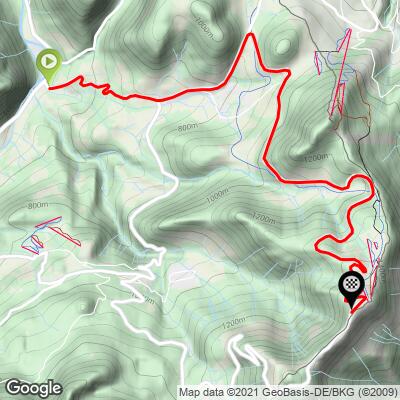
 Ride 10.8 km (6.7 mi) gaining 1,003 m (3,292 ft) at a 9.3% average grade, starting from 528 m (1,733 ft) and finishing at 1,532 m (5,025 ft). The steepest kilometer averages 12.5%, the steepest 500 meters 13.6%, and short ramps reach into the low 20s (22.7% over 100 meters) - a demanding, sustained climb with little flat recovery.
Roadway: Excellent, well-maintained asphalt the entire way from Unterau to the summit - toll revenue funds a higher standard of upkeep than a typical valley road. Expect a narrow, viewless opening pitch out of Unterau before the road climbs into open high pasture near Oberau and the tollbooth.
Traffic: Light. As a private toll road, day-to-day car and motorcycle volume runs well below a comparable free Alpine pass, and cyclists cross the tollbooth on a dedicated free lane rather than queuing with paying traffic. Motorcycles are the main hazard on weekend afternoons, especially on the steep hairpins near the top.
Parking: There's no dedicated cyclist lot at the Unterau start - park considerately along the road, or base yourself in Berchtesgaden (about 3 km away) and ride out to the climb. If you're combining the ride with a drive-up visit, the summit itself has roughly 400 spaces at the viewpoints.
Provisions: None along the climb itself - the nearest cafes and shops are in Berchtesgaden, at the base. There's a kiosk and mountain hut with food and drink at the summit, once you're through the tollbooth.
Gear: Compact or triple gearing is worth having - this is a sustained high-single-digit-to-low-teens grade with little flat recovery, and the exposed summit ridge can be windy and noticeably cooler than the valley floor even in summer.
Before heading out on any cycling adventure check out our Things to Bring on a Cycling Trip and use our interactive check list to ensure you don't forget anything.
Combine this with Rossfeld South for a full loop over the ridge and back down via Obersalzberg, or simply descend the way you came for an out-and-back. Kehlsteinhaus (Eagle's Nest) - Hitler's WWII-era mountaintop retreat, and a legendary if technically off-limits climb - sits above the same town; see PJAMM's Kehlsteinhaus page for the full story, including a fully legal alternate route that uses this same Roßfeldstraße.
Use the "Routes in the Area" tool to see other bike climbs around Berchtesgaden.
ROUTE MAP
MEMBER RATING
CURRENT WEATHER
PJAMM TRIPS ADVENTURE STARTER BUNDLES
Check out PJAMM Adventure's prepackaged (self-guided) cycling trips. They will help you plan, document and conquer your next adventure.
NEARBY CLIMBS (0) RADIAL PROXIMITY
FROM No Climbs Found
MEMBER REVIEWS & COMMENTS
Let us know what you thought of this climb. Signup for our FREE membership to write a review or post a comment.
Already have an account?
LOG IN HERE
