
21.2
PDI
29.4 mi
DISTANCE
5,434 ft
GAINED
3 %
AVG. GRADE
FULL CLIMB STATS
Page Contributor(s): Ard Oostra, Montreux, Switzerland.
INTRO
Idéón Antron is a long climb: 47.3 km (29.4 mi) from near sea level on the west side of Heraklion to the Nida plateau on Mount Ida (Psiloritis), at 1,429 m (4,688 ft). It gains 1,656 m (5,434 ft) at a 3.0% average, which is a gentle number for a long day in the saddle. The steepest kilometer averages 8.2% and the steepest 5 km (3.1 mi) 6.1%.
The goal is the Idaean Cave, where legend says the goddess Rhea hid the infant Zeus from his father Cronus. The route climbs through the mountain village of Anogia, at 738 m (2,421 ft), before the road runs on to the high, bare Nida plateau, where goats graze in summer.
Nida is a destination in its own right, with a tavern, a monument and the cave itself within reach of the end of the road.
PLAN YOUR ROUTE
 We've partnered with Sherpa-Map.com to bring you the best route planning tool. With a PRO Membership you can use this climb as a reference when creating your route.
 Idéón Antron covers 47.3 km (29.4 mi) from near sea level to 1429 m (4,688 ft), gaining 1,656 m (5,434 ft) at a 3.0% average grade.
The average is low because so much of the route is gentle, but the climb does have steep sections. The steepest 100 yards reach 11.4%, the steepest half mile (0.8 km) averages 8.4%, the steepest kilometer 8.2% and the steepest mile (1.6 km) 7.5%. The steepest 5 km (3.1 mi) averages 6.1%.
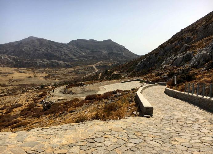
Roadway: The road is paved from Heraklion through Anogia to the Nida plateau. The upper mountain road can be rough and uneven in places, so ride with care on descents and carry a spare tube. The final stretch to the cave parking is an unpaved, bumpy track, so the practical finish is the Nida plateau, with the cave a short walk or rough ride beyond.
Traffic: City traffic leaving Heraklion, then local traffic through Anogia, then quiet mountain road to Nida. In summer goats graze on the plateau and can be on the road, and tour vehicles and cars reach the cave and tavern, so keep your speed in check on the descent.
Parking: If you are driving up to ride only the upper part, the tavern on the west side of the Nida plateau offers parking at the base, and a rough road leads on to a lot just before the cave entrance. From the tavern it is a marked walk of about 580 m (0.4 mi) to the cave.
This is a full-day effort: 47.3 km (29.4 mi) one way, starting at sea level in Crete's heat and finishing at 1,429 m (4,688 ft) where it is much cooler, with a long descent to follow. Carry extra water and food, a windproof layer and sun protection.
Anogia, at 738 m (2,421 ft), is the last village of any size on the way up, so it is a good place to stop. The tavern at Nida also serves food. In November the light fades early in the mountains, so start early.
Before heading out on any cycling adventure check out our Things to Bring on a Cycling Trip and use our interactive check list to ensure you don't forget anything.
Anogia is the key stop. The village has about 2,240 residents, a strong tradition of Cretan lyra and mandolin music and a place in Cretan resistance history: it was central to the 1944 abduction of General Kreipe, and German forces destroyed about 800 houses on August 13, 1944.
The Yakinthia festival is held each July on the Nida plateau.
At the Idaean Cave, excavation from the 1880s produced votive offerings from the 13th century BC to Roman times, now in the Heraklion Archaeological Museum. Plato mentioned the cave in The Laws.
The site keeps seasonal opening hours, so check before you go.
For another Cretan Zeus cave, see our Dikteon Andre climb. Check current conditions at Nida with our Weather tool before you set out.
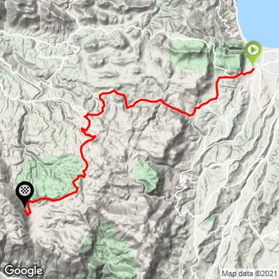
ROUTE MAP
MEMBER RATING
CURRENT WEATHER
PJAMM TRIPS ADVENTURE STARTER BUNDLES
Check out PJAMM Adventure's prepackaged (self-guided) cycling trips. They will help you plan, document and conquer your next adventure.
NEARBY CLIMBS (0) RADIAL PROXIMITY
FROM No Climbs Found
MEMBER REVIEWS & COMMENTS
Let us know what you thought of this climb. Signup for our FREE membership to write a review or post a comment.
Already have an account?
LOG IN HERE
