
29.7
PDI
15.2 mi
DISTANCE
5,107 ft
GAINED
6 %
AVG. GRADE
FULL CLIMB STATS
Page Contributor(s): Bryant Robbins, Palmer, AK, USA
INTRO
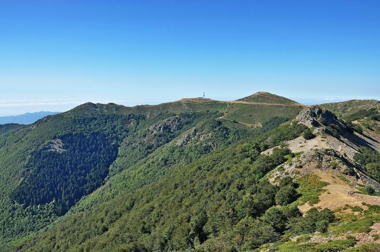
Turó de l'Home climbs 24.4 km (15.2 mi) and 1,557 m (5,107 ft) from Sant Celoni, Catalonia (178 m/585 ft) to the 1,645 m (5,396 ft) summit of the Montseny massif's highest peak - the tallest paved-road climb in the Catalan Coastal Range and one of the biggest single climbs anywhere near Barcelona. The average grade is 6.0%, but it's an uneven 6.0%: a long, steady lower half through Campins gives way to sharper pitches in the upper half, where the steepest kilometer averages 10.9% and short ramps touch into the high teens.
The route runs almost entirely through the beech and oak forests of the Montseny Natural Park, a UNESCO Biosphere Reserve since 1978, with the Mediterranean coastline and, on a clear day, Barcelona itself visible from the open summit. Traffic is noticeable for the first few kilometers out of Sant Celoni before thinning to nearly nothing once past Campins. The final roughly 1.5 km, beyond a vehicle gate near the Plana Amagada parking area, is closed to cars - riders and hikers only, past a cattle grid, to a summit that once held a military installation and now hosts a small astronomical observatory and radio antennas.
Riders often cite this as one of the toughest, longest single climbs accessible from the Barcelona area, widely rated an Hors Catégorie ascent by the region's climbing community.
PLAN YOUR ROUTE
 We've partnered with Sherpa-Map.com to bring you the best route planning tool. With a PRO Membership you can use this climb as a reference when creating your route.
 Turó de l'Home averages 6.0% over 24.4 km (15.2 mi) of climbing and 1,557 m (5,107 ft) of gain, but the grade is far from steady. The steepest 100 yards reaches 17.4%, and sustained over a full kilometer, the steepest section still holds 10.9% - short, sharp pitches concentrated in the upper half of the route, above Campins.
Widen the window and the picture evens out: the steepest quarter mile averages 15.4%, the steepest full mile 10.0%, and the steepest 5 km stretch settles to 8.6%. In practice, that means a long, manageable lower two-thirds of the climb followed by a genuinely hard final third, where the road repeatedly kicks up well into double digits before easing again near the summit.
Roadway: The road is paved from Sant Celoni all the way to the Plana Amagada parking area, and riders consistently describe this lower and middle section as being in good condition. Beyond Plana Amagada, a vehicle gate closes the final roughly 1.5 km to cars - the pavement here is older and patchier, with potholes in places, though recent rider reports (including one from within the past month) note the upper section has been partially resurfaced and is no longer as rough as it once was. A cattle grid crosses the road near the gate - take it carefully. The park is typically rideable from mid-April through November, with snow possible on the summit outside that window.
Traffic: Traffic is light to moderate for the first few kilometers out of Sant Celoni, where cars and motorbikes use the road, dropping off sharply after the roundabout near Campins - most riders describe the middle and upper climb as very quiet. Beyond the Plana Amagada gate, cars are not permitted at all, leaving the final stretch to cyclists and hikers only.
Parking: Roadside parking is available in Sant Celoni near the start, and again at the Plana Amagada car park beyond which the road closes to vehicles - a common option for riders or hikers who want to shorten the effort to just the steepest final push to the summit.
Sant Celoni and Campins, in the first few kilometers, are the last places to reliably find a shop or cafe - after that, services disappear for the remaining 20-plus kilometers to the summit, though several natural springs along the route offer a place to refill bottles with cold water. A compact crank and a wide-range cassette (30-34 teeth or larger in back) are genuinely useful here, not optional - the steep, punchy upper third comes after significant fatigue and rewards low gearing.
Weather at 1645 m changes fast: several riders report being caught by sudden mist, wind, and cold within the last few kilometers even on a warm summer day in Sant Celoni, so packing a light long-sleeve layer for the descent is worth it regardless of season.
Before heading out on any cycling adventure check out our Things to Bring on a Cycling Trip and use our interactive check list to ensure you don't forget anything.
Sant Celoni is a workaday Catalan town about an hour north of Barcelona by car or train, with a full range of lodging and restaurants and easy access to the AP-7/C-35 corridor.
The climb itself is the main attraction here rather than the town - most of the ride passes through the Montseny Natural Park's beech, oak, and pine forests, a UNESCO Biosphere Reserve since 1978, with views opening up to the Mediterranean coast and, on clear days, Barcelona from the summit.
The summit area is a former military site, now home to a small astronomical observatory and a cluster of radio antennas rather than any services, so this is very much a there-and-back effort - bring what you need.
Riders looking to extend the day sometimes descend toward Viladrau or Seva on the far side of the massif before looping back, or add the nearby Coll Formic climb - see our Routes in the Area tool for other climbs nearby.
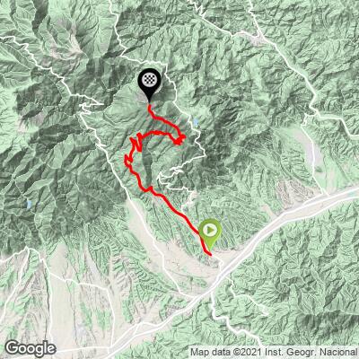
ROUTE MAP
MEMBER RATING
CURRENT WEATHER
PJAMM TRIPS ADVENTURE STARTER BUNDLES
Check out PJAMM Adventure's prepackaged (self-guided) cycling trips. They will help you plan, document and conquer your next adventure.
NEARBY CLIMBS (0) RADIAL PROXIMITY
FROM No Climbs Found
MEMBER REVIEWS & COMMENTS
Let us know what you thought of this climb. Signup for our FREE membership to write a review or post a comment.
Already have an account?
LOG IN HERE
