
16.1
PDI
9.8 mi
DISTANCE
3,039 ft
GAINED
5.2 %
AVG. GRADE
FULL CLIMB STATS
Page Contributor(s): Bryant Robbins, Palmer, AK, USA
INTRO
This is the long way to Puerto de las Palomas. Most people know the pass from the hairpins above Zahara; our route comes at it from the east instead, up a quiet back road from the valley below Montecorto, past the hamlet of Gaidóvar, through the whitewashed streets of Grazalema and then up the CA-9104 to the top. It's 15.7 km (9.8 mi) and 926 m (3039 ft) of climbing at 5.2%, from 362 m (1188 ft) to 1182 m (3878 ft).
After an easy first kilometer, the CA-9123 settles into 5-7.5% for seven kilometers, with the grey limestone walls of the sierra getting closer the whole way. Then the road tips down for about a kilometer onto the A-372 and into Grazalema, where you get fountains, cafés and - on a sunny weekend - a lot of parked cars. The hard part is after the village. The Zahara road starts gently, then kilometer 14 averages 10%, the steepest of the climb, and it stays close to 8% through the pines and rock cuttings until it levels out at the pass.
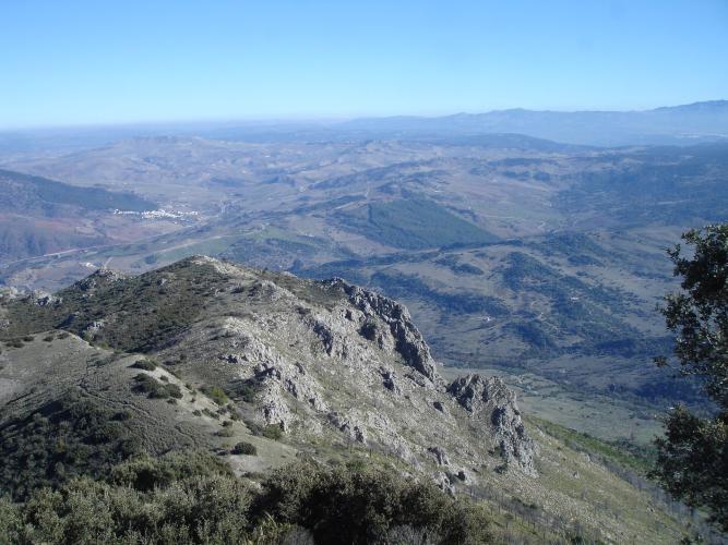
The sign at the top has long put the pass at 1357 m. Don't believe it - the road tops out at about 1190 m, which is what your computer will tell you. The view is the real point: from the small car park and lookout you see across the north of Cádiz and Málaga provinces and into Seville, with the Zahara-El Gastor reservoir below. The Vuelta a Andalucía has used the pass too - the 2020 opening stage crossed it from Zahara before finishing in Grazalema, a stage Jakob Fuglsang won.
PLAN YOUR ROUTE
 We've partnered with Sherpa-Map.com to bring you the best route planning tool. With a PRO Membership you can use this climb as a reference when creating your route.
Las Palomas climbs 15.7 km (9.8 mi) from 362 m (1188 ft) to 1182 m (3878 ft), with 926 m (3039 ft) of climbing at an average of 5.2%. The road peaks at 1196 m just before the end of our route, and there's about 107 m (350 ft) of descent along the way.
km 0-1: 1.8% - a gentle start on the CA-9123
km 1-8: 5 to 7.5% - steady climbing past Gaidóvar
km 8-9: -4.6% - downhill onto the A-372
km 9-11: 6.3% then 8.1% - up into and through Grazalema
km 11-12: 3.8% - out of the village onto the Zahara road
km 12-13: 5.8%
km 13-14: 10% - the steepest kilometer
km 14-15: 7.9%
km 15-15.7: easing to the pass
The steepest kilometer averages 10.1%, the steepest half kilometer 13.4%, the steepest 2 km 8.7% and the steepest 5 km 7%.
Roadway: Paved throughout. The CA-9123 from the valley to Grazalema is a narrow, winding country road through scrub and limestone; the A-372 through the village is a proper main road; the CA-9104 above it is a twisting two-lane mountain road with stone parapets on the outside of the bends. The CA-9104 was shut for months after the February 2026 storms and reopened on 29 June 2026, once emergency repairs between its km 1 and 2 above Grazalema were done - expect temporary plastic barriers on that stretch until the permanent guardrail goes in. Otherwise the pass is normally open all year, though snow and ice can close the top on the odd winter day - check DGT (dgt.es) if the weather has turned.
Traffic: Very light on the CA-9123 below Gaidóvar. It picks up sharply in Grazalema, a busy village for day-trippers at weekends and holidays, and the CA-9104 carries most of the visitor traffic between Grazalema and Zahara, so expect cars on weekends and holidays. Early mornings on weekdays are the quiet time.
Parking: There's not much room at the bottom. The easier option is to park in Grazalema - there are spaces along the A-372 at the eastern entrance to the village (map) - and roll down the CA-9123 to start. There's also a small car park at the pass itself.
Gear: Most of the climb is 5-7%, but kilometer 14 above Grazalema averages 10% with a half kilometer around 13%, so a compact with a 30 or 32 tooth largest cog is a sensible minimum. The top sits about 800 m (2600 ft) above the start and catches the wind - bring a layer for the descent outside summer, and sunscreen and plenty of water in it.
Provisions: Grazalema, at km 9-11, is the stop: bakeries, cafés, a couple of small supermarkets and public fountains in the streets. There's nothing between the village and the pass, and nothing on the CA-9123 before it, so fill up there.
Before heading out on any cycling adventure check out our Things to Bring on a Cycling Trip and use our interactive check list to ensure you don't forget anything.
Grazalema is the base. It's one of the wettest places in Spain - the hills catch the Atlantic weather - which is why the Sierra de Grazalema is so green by Andalusian standards. The village has a good spread of guesthouses and restaurants serving mountain food from the sierra, and it's small enough to walk in ten minutes.
On a rest day, the Pinsapar trail starts at Las Canteras, a couple of kilometers up the CA-9104 from Grazalema. It runs through a forest of pinsapo, a rare Spanish fir that survives in only a few mountain ranges of southern Spain. Access is limited: it's inside the nature reserve, so you need a permit booked in advance through the El Bosque visitor center, and from 1 June to 15 October you can only go in with an authorized guide.
From the pass, the obvious way home is the descent to Zahara de la Sierra, a white village under a Moorish castle tower on a rock above its reservoir. Ronda is about 30 km east if you want a city base, and Puerto de Pedro Ruiz starts in Ubrique, south-west of Grazalema.
ROUTE MAP

MEMBER RATING
CURRENT WEATHER
PJAMM TRIPS ADVENTURE STARTER BUNDLES
Check out PJAMM Adventure's prepackaged (self-guided) cycling trips. They will help you plan, document and conquer your next adventure.
NEARBY CLIMBS (0) RADIAL PROXIMITY
FROM No Climbs Found
MEMBER REVIEWS & COMMENTS
Let us know what you thought of this climb. Signup for our FREE membership to write a review or post a comment.
Already have an account?
LOG IN HERE
