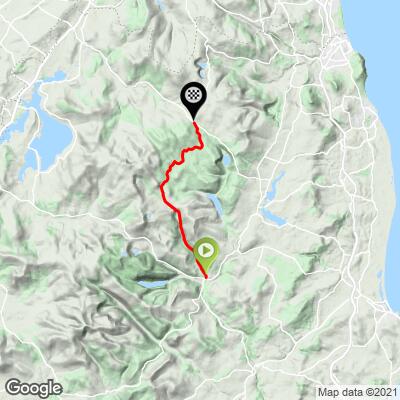
![Cycling Sally Gap, Ireland PJAMM Cyclist rides past street signs reading "Warning roads in the Sallygap area may be impassable in the winter months," and "Road unsafe for horse drawn caravans"]()
Cycling Sally Gap, Ireland
Ride 19.3 kilometers gaining 405 meters at 1.7% (2.9% climb only).
This is a very scenic and fun climb in the Wicklow Mountains, passing by Glenmacnass Waterfall.
![Cycling Sally Gap, Ireland photo collage shows PJAMM Cyclist wearing PJAMM Cycling Ireland Jersey, bike parked next to street sign warning that roads in the area may be impassible in winter]()
Beginning at a small intersection adjacent to a little cafe and bar, the Sally Gap climb doesn’t start with much of a punch. For the opening kilometers -- yes kilometers now unlike England across the way -- the road passes a few houses and parallels a river.
![Cycling Sally Gap, Ireland street signs point to Bearna, Bhealach Sailearnain, Sallygap, Ath Cliath, Dublin]()
Climb begins by riding north on Route 115 from its intersection with Route 755 in Laragh.
As the gradient kicks up, you’ll have a view of a massive canyon and waterfall to your left. The road takes you right up to the head of the waterfall. Judging by gradient, this portion of the climb is the toughest. Beyond the waterfall, the landscape becomes very barren, and on the day we rode in early June the winds were absolutely howling. There are a few minor descents and consistently mild grades that see you to the finish point at a four way intersection.
![Cycling Sally Gap, Ireland bike parked on road side next to Glenmacnass Waterfall]()
Glenmacnass Waterfall (meaning, “the glen of the hollow of the waterfall”).
Glenmacnass Waterfall is a popular tourist attraction and viewpoint in the Wicklow Mountains on the route to Sally Gap.
![Cycling Sally Gap, Ireland photo collage shows bike parked next to road sign warning of winding road, PJAMM Cyclist ride on straight roadway surrounded by trees and pastureland; aerial drone view shows road running parallel to river]()
Climb summary from PJAMM Ambassador Stephen Rochford of Longwood, Co. Meath:
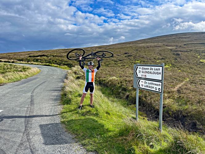
This is a beautiful climb up to the famous Sally Gap in the Wicklow Mountains. Starting in the village of Laragh right beside the historic monastic site of Glendalough, we slowly ascend on a narrow road for 19km at just under 2% average gradient for a total gain of 361m. Not a tough climb by any stretch of the imagination but its length can sap the legs a little.
The first 5km are almost flat with just a few short ramps at the start, as we roll up through the wooded valley alongside a small stream. Then comes the waterfall section, 4km at 5% gradient. The view of Glenmacnass Waterfall on your left and looking back down the valley is definitely worth stopping for a photo.
![Cycling Sally Gap, Ireland photo collage shows views of the glacially formed Glenmacnass Valley]()
Glenmacnass Valley was glacially formed.
Shortly after passing the waterfall there is a brief descent and then the road continues to wind up toward the top of the gap for another 8km at 1.5%. The trees have now disappeared and there are wide views all across the Wicklow Mountains National Park from here.
![Cycling Sally Gap, Ireland aerial drone view of road snaking through open pastureland in Wicklow Mountains National Park]()
At the top of the Sally Gap there is a crossroads. Continuing straight on will take you to the final part of the climb up to Kippure Mast, which is described in more detail here. Turning left will take you down toward the village of Manor-Kilbride, and turning right will bring you up the Lugalla climb and past the "Guinness Lake," Lough Tay, where the TV series Vikings is filmed.
![https://pjammcycling.com/climb/2740.Kippure PJAMM Cyclist holds bike above his head at climb finish next to road signs for Glendalough and Laragh]()
Climb finish.
Traffic in the area is usually light but can get substantially heavier at weekends and during the summertime. The road surface is generally good but there are some rough patches. The top section of the climb is very exposed and the weather can change quickly here. A south wind will make you fly up the climb, but a north wind can make this very challenging.
![]()
That’s a wrap!