Wicklow Gap East Bike Climb - PJAMM Cycling

8.9
PDI
6.2 mi
DISTANCE
1,738 ft
GAINED
5.4 %
AVG. GRADE

FULL CLIMB STATS

Page Contributor(s): Ard Oostra, Montreux, Switzerland

INTRO

Wicklow Gap is a very popular cycling climb about 50 kilometers south of Dublin.

PLAN YOUR ROUTE

We've partnered with Sherpa-Map.com to bring you the best route planning tool. With a PRO Membership you can use this climb as a reference when creating your route.

See more details and tools regarding this climb's grade via our interactive Profile Tool.
Information Not Available

If you have any information regarding this climb, we'd like to hear from you. Click the CONTRIBUTE button to share your thoughts with us.

Information Not Available

If you have any information regarding this climb, we'd like to hear from you. Click the CONTRIBUTE button to share your thoughts with us.

Before heading out on any cycling adventure check out our Things to Bring on a Cycling Trip and use our interactive check list to ensure you don't forget anything.
Information Not Available

If you have any information regarding this climb, we'd like to hear from you. Click the CONTRIBUTE button to share your thoughts with us.

ROUTE MAP

MEMBER RATING

Not Yet Rated
-
Road
-
Traffic
-
Scenery

CURRENT WEATHER

PJAMM TRIPS ADVENTURE STARTER BUNDLES

Check out PJAMM Adventure's prepackaged (self-guided) cycling trips. They will help you plan, document and conquer your next adventure.
ALL TRIPS
Browse all of our prepackaged trips and find your next adventure!

NEARBY CLIMBS (0) RADIAL PROXIMITY

FROM
No Climbs Found

MEMBER REVIEWS & COMMENTS

Let us know what you thought of this climb. Signup for our FREE membership to write a review or post a comment.
Already have an account?
ROUTE MAP
PROFILE TOOL
Route Data
S.G. (%)
hide
Segment Data
hide
CLIMB SUMMARY

bike parked next to stone ruins in grassy hillside

Ride 9.9 kilometers gaining 530 meters at 5.4% average grade.

photo collage shows stone ruins, blue and white buildings in small Irish village, stream in green hillsides

Hey, not all climbs have to leave you begging for mercy. Wicklow Gap may not be the most difficult climb in Ireland, but you’ll not regret adding it to your itinerary. Gentle gradients bring you out of the small town of Glendalough and into very rural country. Expect some traffic out here though, as this area seems to not only be popular for cyclists but hikers and sightseers alike. The summit of our Eastern route ends at the saddle of the pass, but if you’re in the mood for a challenge - turn left onto the gated off access road and ride another three kilometers at 6.4% to the tippy top.

stone monument welcomes to Glendalough, County of Wicklow

Climb begins in Glendalough in the County of Wicklow.

Glendalough was settled in the sixth century as a monastic settlement.

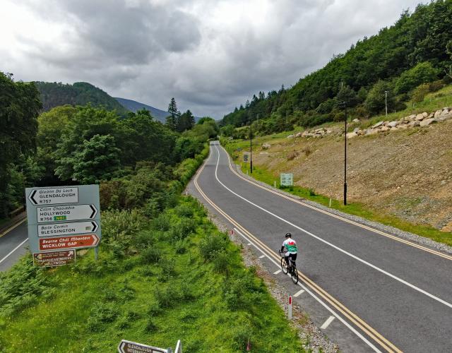
photo collage shows PJAMM Cyclist riding on wide open roadway, surrounded by lush Irish hillsides

Wide open and stunning views along the climb.

The grade most of the climb is mild, although there is a 9.6% 500 meter segment which begins at km 2.6.  

photo collage shows aerial drone view of quarry sites

Granite quarry sites around kilometer 2.5.

There are obvious remnants of substantial granite quarries along the mid point of the climb, including the ruins of an old quarry house to the left just off the road at kilometer 3.4.

ruins of an old quarry house

aerial drone view shows roadway snaking along wide open Irish hillsides, green pastures, three hairpin turns

There are three big hairpins on the climb from km 7.3 to 8.4.

street sign at climb finish, Wicklow Gap

Finish the climb at Wicklow Gap.

That’s a Wrap!!