
17.4
PDI
7.6 mi
DISTANCE
2,655 ft
GAINED
6.6 %
AVG. GRADE
FULL CLIMB STATS
INTRO
The Flüela starts a few minutes' ride from Davos Dorf station, and for its first 7 km it feels more like a valley ride than a pass: a steady 5-6% up the Flüela valley through the forest, past the hamlet of Tschuggen and the barrier that shuts the road for winter. Then the trees thin out, the grade jumps to 8-9%, and the last 5 km go up through open, rocky ground to the Flüela Hospiz at 2383 m (7818 ft). In all it's 12.2 km (7.6 mi) and 809 m (2655 ft) of climbing at 6.6%.
It's a working road. In summer the Flüela is the link between Davos and the Lower Engadin, so you share it with cars, motorbikes and the yellow PostBus. In winter the Vereina rail tunnel takes over and the pass closes. On Tuesdays in summer a six-horse post coach makes the trip from Davos-Platz up to the Hospiz and back, which is a fine thing to pass on a bike.
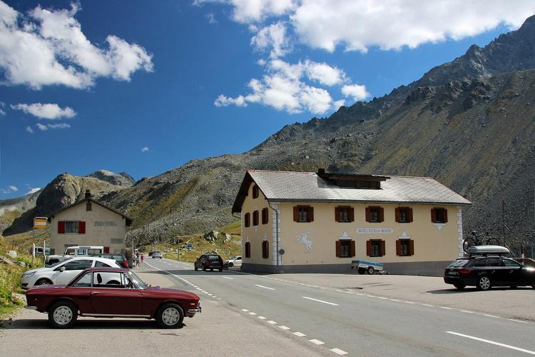
At the top, the Hospiz has a restaurant and rooms, and small lakes sit beside the road on the summit plateau. You can turn around for a quick descent to Davos, but the better day carries on down to Susch and comes back over the Albula - see Travel Tips.
PLAN YOUR ROUTE
 We've partnered with Sherpa-Map.com to bring you the best route planning tool. With a PRO Membership you can use this climb as a reference when creating your route.
The Flüelapass from Davos is 12.2 km (7.6 mi) long and climbs 809 m (2655 ft) from 1573 m (5160 ft) in Davos Dorf to the pass at 2383 m (7818 ft), an average of 6.6%, without a single meter of descent.
The first 7 km (4.3 mi) are steady and moderate, every kilometer between 4.9% and 6.2%, as the road climbs the Flüela valley to Tschuggen at about km 6.2 (mi 3.9). Then it steps up: km 8 and 9 are both 8.8%, km 10 is 7.0%, km 11 8.0% and km 12 8.5%, before the last 200 m ease into the summit.
The steepest 500 m averages 9.8%, the steepest kilometer 9.1%, the steepest 2 km 8.8% and the steepest 5 km 8.2%. Nothing goes much past 10.5%, even over 100 yards - the altitude does more damage than the gradient.
Roadway: A wide, two-lane main pass road, asphalt from Davos to the top and in good condition. The Flüela closes for winter. Under the canton's agreement with the Pro Flüela association it stays open into early January - it closed on January 5-7 in each of the last three winters - and reopens between mid-April and mid-May depending on snow (April 21 in 2026). The pass was open in late October 2026; check current status on the canton's road information site, strassen.gr.ch, especially in spring and early winter.
Traffic: Busy by mountain-road standards in summer, with cars, campers, motorbikes and PostBus line 331 between Davos and Susch. Early mornings are the calmest time to ride it. In spring 2026 the road between Davos and Susch was given over to bikes and walkers for a car-free FreiPass day before it opened to cars - watch graubuenden.ch for the next one.
Parking: Davos Dorf station is less than 1 km from the start, so arriving by Rhaetian Railway is the simplest option; if you drive, park in Davos Dorf rather than along the pass road. At the top there's parking at the Hospiz and a lot about 600 m east of the pass used by hikers heading for the Schwarzhorn.
Gear: Standard compact gearing handles 8-9%, though above 2000 m the thin air makes the last 5 km feel harder than the numbers. Pack a windproof and full-finger gloves - it can be cold at the pass even in summer, and the descent is long, fast and open.
Provisions: Stock up in Davos before you leave town. The Flüela Hospiz on the pass has a restaurant with game specialties and home cooking, and rooms upstairs; it opens for the summer season (May 22 in 2026) and keeps long hours once it does.
Before heading out on any cycling adventure check out our Things to Bring on a Cycling Trip and use our interactive check list to ensure you don't forget anything.
The big day from Davos is the loop the Flüela is half of: over the pass to Susch, up the Engadin to La Punt, back over the Albula to Bergün and Filisur, then up the Landwasser valley to Davos - about 111 km (69 mi). Our Flüelapass (Susch) and Albulapass (La Punt) pages cover the other two big climbs on it. If your legs give out on the far side, PostBus line 331 runs over the pass between Susch and Davos and carries bikes on some runs - look for the bike symbol in the timetable and reserve a space.
For a recovery spin, the Davosersee is about 1 km north of the start, and a lap of the lake is flat and easy. Davos also has the Kirchner Museum, home to the largest collection of work by Ernst Ludwig Kirchner, the German Expressionist painter who moved here in 1917 - a good rainy-day stop.
ROUTE MAP

MEMBER RATING
CURRENT WEATHER
PJAMM TRIPS ADVENTURE STARTER BUNDLES
Check out PJAMM Adventure's prepackaged (self-guided) cycling trips. They will help you plan, document and conquer your next adventure.
NEARBY CLIMBS (0) RADIAL PROXIMITY
FROM No Climbs Found
MEMBER REVIEWS & COMMENTS
Let us know what you thought of this climb. Signup for our FREE membership to write a review or post a comment.
Already have an account?
LOG IN HERE
