

21.3
PDI
7.6 mi
DISTANCE
3,110 ft
GAINED
7.7 %
AVG. GRADE
FULL CLIMB STATS
Page Contributor(s): Luke Hise, AZ
INTRO
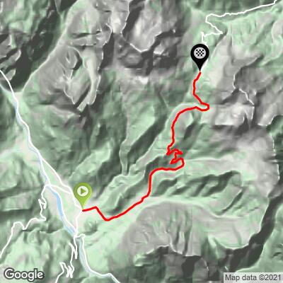
Passo Duran climbs 12.3 km (7.6 mi) from Agordo in the Cordevole valley to the pass at 1,601 m (5,253 ft), gaining 948 m (3,110 ft) at a 7.7% average grade. The road crosses from the Agordino into the Zoldo valley, linking Agordo with Pralongo, and it is a Dolomite pass that regularly appeared in the Giro d'Italia - the 2012 race was the last to climb it.
The grade is what defines the ride (in addition to the views, of course). The steepest mile averages 9.8%, the steepest kilometer 9.9% and the steepest 5 km (3.1 mi) 9.4%, so there is little real recovery on the way up. Our difficulty ranking puts it 864th in the world.
At the top you find restaurants, a rifugio and a small church, and walking trails lead off into the surrounding Dolomites. The pass is lower and less famous than the big Dolomite passes nearby, which makes it a good climb for a quieter day in the Belluno Dolomites.
PLAN YOUR ROUTE
 We've partnered with Sherpa-Map.com to bring you the best route planning tool. With a PRO Membership you can use this climb as a reference when creating your route.
Passo Duran from Agordo covers 12.3 km (7.6 mi) and gains 948 m (3,110 ft) at a 7.7% average grade, finishing at the 1601 m (5,253 ft) pass.
The grade is steady and steep rather than variable: the steepest 100 yards reach 10.6%, the steepest half mile (0.8 km) averages 9.9%, and the steepest mile (1.6 km) 9.8%. The steepest 5 km (3.1 mi) averages 9.4% and the steepest 10 km (6.2 mi) 8.5%, so most of the climb sits close to the overall average or above it.
Roadway: The road is paved from Agordo to the pass. It is a through road between the Cordevole and Zoldo valleys and a former Giro d'Italia climb. The pass is normally open year-round except after heavy snow, and in August 2025 it served as one of the alternative routes into the Val di Zoldo when the main valley road was closed by a rockfall near Soffranco. The Zoldo side was hit by a debris flow in July 2024 about 4 km (2.5 mi) below the summit, so if you plan to descend or loop over to Dont, check current road status before you go.
Traffic: Expect valley and visitor traffic on a through road, with the most activity around the restaurants and rifugi at the top on summer weekends, August in particular.
Parking: There is no organized parking lot at the pass. Roadside parking is available near the rifugi, but leave the spaces by Rifugio Passo Duran for its guests. Parking is rarely a problem except on August weekends.
The summit is at 1,601 m (5,253 ft), so it is noticeably cooler and windier than Agordo at about 614 m (2,014 ft) - bring a windproof layer for the descent even on a warm day.
The pass has restaurants and rifugi, including Rifugio Passo Duran "C. Tome", Rifugio San Sebastiano and Rifugio Bruto Carestiato about 1.8 km (1.1 mi) away, so you can refuel at the top and do not need to carry a full day of food. Fill your bottles in Agordo before you start.
*Note from Sam - Rifugio Duran has probably the best apple strudel in the Dolomites.
Before heading out on any cycling adventure check out our Things to Bring on a Cycling Trip and use our interactive check list to ensure you don't forget anything.
Agordo, at 611 m (2,005 ft), is a town of about 4,000 people roughly 20 km (12 mi) northwest of Belluno and 100 km (62 mi) north of Venice. It is best known as the long-time home of Luxottica, the eyewear company, and the Museo dell'Occhiale (Eyewear Museum) in Villa Crotta De' Manzoni tells that story.
The central square, Broi, is the heart of the old town, and the Palio dei Cento in August and the Le Miglia di Agordo run in July bring the town to life.
3 km from town in Rivamonte Agordino, the Valle Imperina mines worked copper and pyrite from at least 1417 until 1962 and are now an open-air museum with guided gallery tours (reservation required) and a restaurant on site - see our Rivamonte Agordino page.
The Zoldo side of the pass is covered by our Passo Duran (Dont) page, and Passo Staulanza (Dont) is the natural neighboring climb for a loop. See other climbs nearby, or build a custom route from Agordo, with our Routes in the Area tool.
ROUTE MAP
MEMBER RATING
CURRENT WEATHER
PJAMM TRIPS ADVENTURE STARTER BUNDLES
Check out PJAMM Adventure's prepackaged (self-guided) cycling trips. They will help you plan, document and conquer your next adventure.
NEARBY CLIMBS (0) RADIAL PROXIMITY
FROM No Climbs Found
MEMBER REVIEWS & COMMENTS
Let us know what you thought of this climb. Signup for our FREE membership to write a review or post a comment.
Already have an account?
LOG IN HERE
