
19.8
PDI
8.2 mi
DISTANCE
3,019 ft
GAINED
7 %
AVG. GRADE
FULL CLIMB STATS
INTRO
The Silvretta-Hochalpenstrasse climbs 13.2 km (8.2 mi) from Partenen in the Montafon valley to the Bielerhöhe, the pass between Vorarlberg and Tirol. It gains 920.2 m (3,019 ft), from 1,095.1 m (3,593 ft) to 2,015.3 m (6,612 ft), at a 7.0% average, and ranks #1,017 on our list of the world's hardest climbs. The road, a toll road when open, continues over the pass and down to Galtür in the Paznaun valley for a total of 22.3 km (13.9 mi), with 34 bends.
The climb is steady and sustained rather than savage. After the village the road tilts up through the toll gate and into the hardest section, where the hairpins come one after another and the grade holds near 9% for kilometers at a time. Past the Vermunt reservoir the road varies from flat to about 10%, and the last stretch passes rugged high-alpine scenery, with snow that can linger into early summer, before the terraces and the Silvretta reservoir at the top.
Important for planning: the Vorarlberg side of the road, from Partenen to the Bielerhöhe, has been closed to public traffic since rockfall and mudslides in summer 2024. The operator, illwerke vkw, decided in March 2026 that it will stay closed until at least summer 2030, with construction planned for 2027 to 2029. The Tyrolean side from Galtür remains open and toll-free during the works, and in summer the Vermuntbahn cable car plus a tunnel shuttle links Partenen with the Bielerhöhe. Check with the operator before planning to ride the closed section.
PLAN YOUR ROUTE
 We've partnered with Sherpa-Map.com to bring you the best route planning tool. With a PRO Membership you can use this climb as a reference when creating your route.
The Silvretta-Hochalpenstrasse averages 7.0% over 13.2 km (8.2 mi) from Partenen to the Bielerhöhe, climbing 920.2 m (3,019 ft) from 1,095.1 m (3,593 ft) to 2,015.3 m (6,612 ft). The official road figures are up to 10% on the straights and up to 12% in the hairpins.
The steepest 0.5 km (0.3 mi) averages 10.5%, the steepest kilometer 9.7%, the steepest 2 km (1.2 mi) 9.4% and the steepest 5 km (3.1 mi) 8.7%, while the steepest 10 km (6.2 mi) average 7.6%. The toughest stretch begins at the toll gate, about 1.5 km (0.9 mi) above the village, and runs for roughly 6 km (3.7 mi) at close to 9%. Beyond the Vermunt reservoir the gradient swings between flat and 10% over 500 m segments, so the effort is easier to manage near the top.
Roadway: The road is paved, narrow and winding, with 34 bends over its 22.3 km (13.9 mi) length. It is normally closed in winter because of avalanche and rockfall risk. Since summer 2024 the Vorarlberg side from Partenen to the Bielerhöhe has been closed to public traffic after rockfall and mudslides, and the operator expects it to stay closed until summer 2030. The Tyrolean side from Galtür is open and toll-free during construction.
Traffic: With the Vorarlberg side closed to public traffic there is no through traffic from Partenen. Trailers are banned on the road, tour buses are limited to 13.8 m (45.3 ft) in length, and overnight parking on the road is prohibited. The Tyrolean approach from Galtür remains open to public traffic.
Parking: In Partenen the Vermuntbahn valley station car park is closed for construction, so use the Tafamuntbahn car park across the road. At the Bielerhöhe there is parking by the reservoir for those arriving from the Galtür side. Overnight parking is not allowed on the road itself.
Provisions: Services at the pass are seasonal and depend on the road being open, so confirm what is open before you ride and carry your own food and water.
Gear: The Bielerhöhe sits at over 2,000 m (6,562 ft), where it is cold and often windy even in summer, so bring a jacket and gloves for the descent. If you plan to use the Vermuntbahn and tunnel shuttle to reach the pass, note that bike transport is uphill only, limited to four bikes per time slot, and needs an advance online booking.
Before heading out on any cycling adventure check out our Things to Bring on a Cycling Trip and use our interactive check list to ensure you don't forget anything.
Partenen is the last village of the Montafon before the high valley, and the Vermuntbahn and Tafamuntbahn start here. In summer the Vermuntbahn cable car combined with a tunnel shuttle is the way to reach the Bielerhöhe from the Vorarlberg side while the road is closed, and it is the best option for riders and walkers who want to explore the pass without the climb.
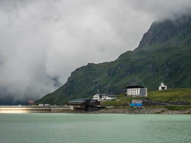
The Bielerhöhe itself, at 2,032 m (6,667 ft), is the highest point of the road and sits beside the Silvretta reservoir, with a dam, terraces and the Silvretta-Haus. The open Tyrolean approach comes up from Galtür in the Paznaun valley, and for through travelers the closure directs campervans, convertibles and motorcycles to the Arlberg pass or tunnel, or the Lechtal. For riders who still want a Silvretta climb in the same trip, the Paznaun side is the one to look at. Check conditions at the pass before you go with our Weather tool.
ROUTE MAP

MEMBER RATING
CURRENT WEATHER
PJAMM TRIPS ADVENTURE STARTER BUNDLES
Check out PJAMM Adventure's prepackaged (self-guided) cycling trips. They will help you plan, document and conquer your next adventure.
NEARBY CLIMBS (0) RADIAL PROXIMITY
FROM No Climbs Found
MEMBER REVIEWS & COMMENTS
Let us know what you thought of this climb. Signup for our FREE membership to write a review or post a comment.
Already have an account?
LOG IN HERE
