
24.8
PDI
8.5 mi
DISTANCE
3,542 ft
GAINED
7.9 %
AVG. GRADE
FULL CLIMB STATS
Page Contributor(s): Erwan Treguier, Brittany, France
INTRO
Lac de la Grande Léchère climbs 13.6 km (8.5 mi) from Notre-Dame-du-Cruet, in the Maurienne valley, gaining 1080 m (3,542 ft) at a 7.9% average grade to a quiet alpine lake at 1658 m (5,438 ft), with views back over the Belledonne range and the distinctive Aiguilles d'Arves.
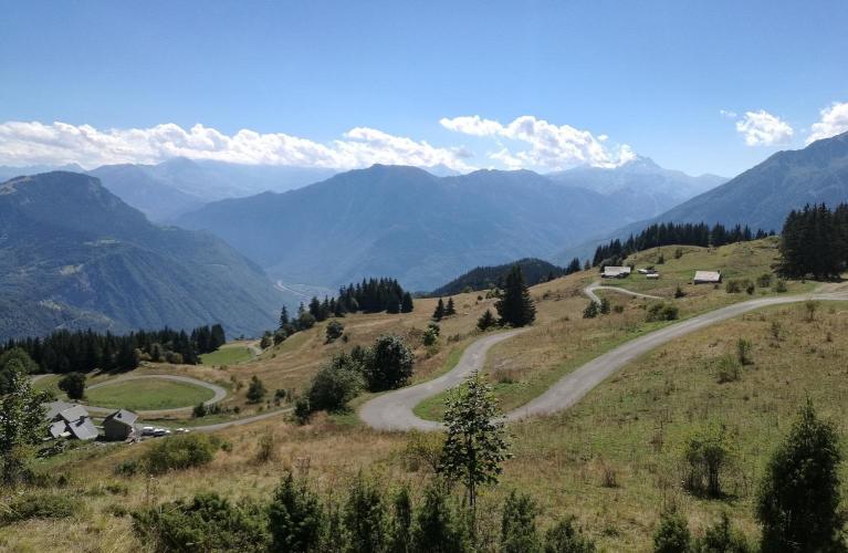
The route climbs through forest and open pasture to Montgellafrey, passing the village's Saint-Théodule church and communal bread ovens, then continues via the hamlet of Le Bey to the lake itself. A mountain refuge at the lake, part of the region's "Qualité Cyclo Maurienne" network, offers food and drink at the top - a welcome stop after a sustained climb with little else along the way.
This is a quiet alternative to the Maurienne's famous cols - Madeleine, Croix de Fer, and Glandon are all a short drive away - and it sees a fraction of their traffic. The road is open seasonally, typically May through October depending on snow.
PLAN YOUR ROUTE
 We've partnered with Sherpa-Map.com to bring you the best route planning tool. With a PRO Membership you can use this climb as a reference when creating your route.
 Lac de la Grande Léchère gains 1,080 m (3,542 ft) over 13.6 km (8.5 mi) at a 7.9% average grade, and the effort is fairly sustained throughout - even the mellowest 5-mile (8 km) stretch still averages 8.4%.
The hardest section comes in the few kilometers before Montgellafrey, where the road holds close to 10% almost continuously - riders should manage effort carefully through this stretch rather than going out too hard from Notre-Dame-du-Cruet. The steepest kilometer on the route averages 10.0%.
Roadway: Paved the entire way from Notre-Dame-du-Cruet through Montgellafrey and Le Bey to the lake, and reported in good condition throughout. This is a well-maintained secondary road rather than a major departmental route, with no notable surface issues reported.
Traffic: Light. This is a quiet, low-traffic road compared to the major Maurienne passes nearby - most vehicles are local or headed specifically to the lake rather than passing through.
Parking: Notre-Dame-du-Cruet has parking near the village center at the base of the climb. Montgellafrey, partway up, also has water and food available if you'd rather split the ride or need a refill.
A wide-range cassette or compact crankset is worth having for the sustained climbing, especially the near-10% stretch below Montgellafrey. Water and food are available in Notre-Dame-du-Cruet and Montgellafrey, and the refuge at the lake itself serves food and drink at the top - so this is a climb where you don't need to carry everything yourself, unlike many of the Maurienne's higher, more remote cols.
Before heading out on any cycling adventure check out our Things to Bring on a Cycling Trip and use our interactive check list to ensure you don't forget anything.
Montgellafrey, partway up the climb, is worth a slow pass rather than a straight ride-through - the Saint-Théodule church and the village's communal bread ovens are genuine, well-preserved pieces of Maurienne mountain heritage.
At the lake, the refuge is part of the region's "Qualité Cyclo Maurienne" network of cyclist-friendly stops, and the view across to the Belledonne range and the distinctive Aiguilles d'Arves is worth lingering for.
This climb sits in the same valley as the Maurienne's most famous cols - Col de la Madeleine, Col de la Croix de Fer, and Col du Glandon are all a short drive from Notre-Dame-du-Cruet - so it pairs naturally with a multi-day trip built around La Chambre or Saint-Jean-de-Maurienne. See other climbs nearby with our Routes in the Area tool.
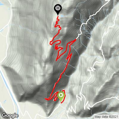
ROUTE MAP
MEMBER RATING
CURRENT WEATHER
PJAMM TRIPS ADVENTURE STARTER BUNDLES
Check out PJAMM Adventure's prepackaged (self-guided) cycling trips. They will help you plan, document and conquer your next adventure.
NEARBY CLIMBS (0) RADIAL PROXIMITY
FROM No Climbs Found
MEMBER REVIEWS & COMMENTS
Let us know what you thought of this climb. Signup for our FREE membership to write a review or post a comment.
Already have an account?
LOG IN HERE
