5.2
PDI
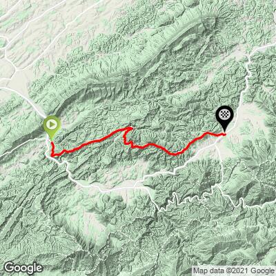
14.6 mi
DISTANCE
1,970 ft
GAINED
0.5 %
AVG. GRADE
FULL CLIMB STATS
Page Contributor(s): Carla and Tom Morton, Granger, IN, USA
INTRO
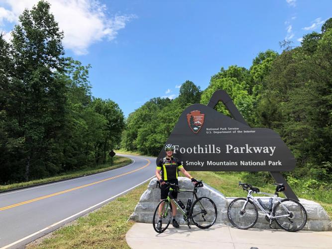
This is the northern half of Foothills Parkway. The Parkway is designated to be a total of 72 miles, but it is unfinished and currently runs only 32 miles, creating the excellent opportunity for a one day out-and-back of the entire Parkway. This segment runs from Walland (the middle of the Parkway) north to the end of the Parkway in Wears Valley. There are eight unnamed overlooks along this segment of Foothills Parkway.
PLAN YOUR ROUTE
There are two ascents along this route - 2.2 miles at the beginning at 6.1% and 3.9 miles beginning at mile 5.9 at 5.4%. The steepest quarter-mile is along the second climb and is 9%.
See more details and tools regarding this climb's grade via the “Profile Tool” button.
Roadway: This is a two lane road in excellent condition with a narrow shoulder throughout most of the ride.
Traffic: Mild.
Parking: If you are doing just this fifteen mile segment, you are probably okay parking on the right side of the road after Foothills Parkway crosses Old Walland Highway, 300 yards before the Foothills Parkway sign and the start of our climb (Map; Street View). An alternative is to park in the "Start Biking" parking lot in Townsend four miles south (Map; Street View).
Provisions: There are no spots for food or beverages along the route. There is Martahon Gas at the finish and spots for provisions in Townsend 4.5 miles south of climb start (Map).
Before heading out on any cycling adventure check out our Things to Bring on a Cycling Trip and use our interactive check list to ensure you don't forget anything.
This route can be done as an out-and-back at 29 miles and 4,500' gained (Map).
Use the “Routes in Area” button on the menu bar to see other bike climbs in this area.
ROUTE MAP
MEMBER RATING
CURRENT WEATHER
PJAMM TRIPS ADVENTURE STARTER BUNDLES
Check out PJAMM Adventure's prepackaged (self-guided) cycling trips. They will help you plan, document and conquer your next adventure.
NEARBY CLIMBS (0) RADIAL PROXIMITY
FROM No Climbs Found
MEMBER REVIEWS & COMMENTS
Let us know what you thought of this climb. Signup for our FREE membership to write a review or post a comment.
Already have an account?
LOG IN HERE