Mt. Donna Buang Bike Climb - PJAMM Cycling

20.6
PDI
10.4 mi
DISTANCE
3,516 ft
GAINED
6.4 %
AVG. GRADE

FULL CLIMB STATS

INTRO

This 10.4 mile bike climb is located in Victoria, Australia. The average gradient is 6.4% and there is a total elevation gain of 3,516 ft, finishing at 4,022 ft.

Use the profile tool, route map, and weather forecast to conquer this cycling climb.

See more details and tools regarding this climb's grade via our interactive Profile Tool.
Information Not Available

If you have any information regarding this climb, we'd like to hear from you. Click the CONTRIBUTE button to share your thoughts with us.

Information Not Available

If you have any information regarding this climb, we'd like to hear from you. Click the CONTRIBUTE button to share your thoughts with us.

Before heading out on any cycling adventure check out our Things to Bring on a Cycling Trip and use our interactive check list to ensure you don't forget anything.
Information Not Available

If you have any information regarding this climb, we'd like to hear from you. Click the CONTRIBUTE button to share your thoughts with us.

ROUTE MAP

MEMBER RATING

Not Yet Rated
-
Road
-
Traffic
-
Scenery

CURRENT WEATHER

PJAMM TRIPS ADVENTURE STARTER BUNDLES

Check out PJAMM Adventure's prepackaged (self-guided) cycling trips. They will help you plan, document and conquer your next adventure.
ALL TRIPS
Browse all of our prepackaged trips and find your next adventure!
Australia
Australia
24 ROUTES
41 POIs
ROUTE STATS (TOTAL)
443.9
mi
DISTANCE
64,453
ft
ELEV. GAIN
Australia: Adelaide
Australia
21 ROUTES
34 POIs
ROUTE STATS (TOTAL)
130.4
mi
DISTANCE
22,651
ft
ELEV. GAIN

NEARBY CLIMBS (0) RADIAL PROXIMITY

FROM
No Climbs Found

MEMBER REVIEWS & COMMENTS

Let us know what you thought of this climb. Signup for our FREE membership to write a review or post a comment.
Already have an account?
ROUTE MAP
PROFILE TOOL
Route Data
S.G. (%)
hide
Segment Data
hide

Climb Profile Not Found
CLIMB SUMMARY

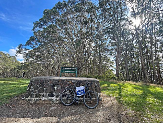
bike parked in front of road sign for Mt. Donna Buang Summit

Cycling Donna Buang, Victoria, Australia

Ride 16.8 kilometers gaining 1,069 meters at 6.4% average grade.

photo collage shows signs and view points in Yarra Ranges National Park

The climb is located in Yarra Ranges National Park (est. 1995; 76,003 hectares/187,800 acres).

Climb Summary by PJAMM Cycling’s Brad Butterfield:

Donna Buang begins ascending just outside the former gold mining town of Warbutorn. There are a number of small cafes that were very lively with both cyclists and motorcyclists on the day that I rolled through. Parking in town is easy to find, or if preferred, there are a number of large pullouts on the climb itself that offer unrestricted parking. The climb stays right around the average gradient mark of 6.4% for the duration, making the 3500 foot climb disappear beneath your wheels without any tough pitches to speak of. Views of the valley below are blocked by what felt like a dense South American jungle to me -- except this is just outside of Melbourne central -- amazing! At the top there is a big grassy knoll, a bathroom, and a large metal structure with a staircase to a viewpoint. To get a view of the surrounding area from the summit, you’ve got to climb the extra 50 feet, or so, up to the top of the observation tower as the trees block the view from ground level even once at the top of the climb. It’s worth it though!

climb start in Warburton, Western Australia

Climb begins in Warburton, Western Australia (pop. 576, 2016).

thick eucalyptus and mountain ash trees

Surrounded by thick eucalyptus and mountain ash forest the entire climb.

photo collage shows beautiful flowers, tropical trees, and thick forestation; signs read Mt Donna Buang

bike parked in slight break in dense forestation next to sign reading "View of Yarra Valley and Dandenongs

Slight break in the forest at kilometer 12.1.

photo collage shows dense forest and fern-lined roadways 

Occasionally the roadway is bordered by ferns in addition to thick forest.

cool carving of an animal into a downed tree stump

dense forestation; signs for Mt. Donna Buang Summit 

photo collage climb's summit; sign for Mt. Donna Buang Summit, 1250 m above sea level; large metal lookout structure