

18
PDI
15.8 mi
DISTANCE
3,775 ft
GAINED
4.5 %
AVG. GRADE
FULL CLIMB STATS
Page Contributor(s): Erwan Treguier, Brittany, France.
INTRO
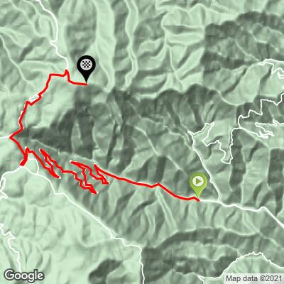
Mont Aigoual South climbs 25.4 km (15.8 mi) from Valleraugue to the summit of Mont Aigoual, the 1567 m (5,141 ft) high point of the Gard and the crown of the Cévennes National Park, gaining 1151 m (3,775 ft) at a 4.5% average. It is the long way up: after a gentle warm-up along the Hérault, the road settles into well over a dozen kilometers of hairpins at a remarkably constant 5%, eases through the village of L'Espérou and over the Col de la Séreyrède, and finishes past the Prat Peyrot ski area at the castle-like weather observatory on the summit. It ranks #1221 on our list of the world's hardest climbs.
Nothing here is steep - the steepest kilometer is just 6.0% - so this is a climb about rhythm and endurance rather than raw gradient. The road is smooth and quiet, climbing from chestnut-covered Cévenol valleys to open, windswept heights, and on a clear day the view from the top takes in the Mediterranean, Mont Ventoux and, in the right conditions, the Alps and the Pyrenees.
The summit has real cycling history. The Tour de France first crossed it in 1987, when Silvano Contini led over the top on the stage from Millau to Avignon, and in 2020 Alexey Lutsenko won a stage finish at the summit. It's also the setting for the race in Tim Krabbé's cult cycling novel The Rider. Weather changes fast up here, so check current conditions before you go with our Weather tool.
PLAN YOUR ROUTE
 We've partnered with Sherpa-Map.com to bring you the best route planning tool. With a PRO Membership you can use this climb as a reference when creating your route.
Mont Aigoual South averages 4.5% over 25.4 km (15.8 mi), and its defining feature is how consistent it is - the steepest kilometer is only 6.0%, and the steepest 5 km (3.1 mi) average 5.2%.
The first 3 km (1.9 mi) out of Valleraugue are a false flat at roughly 2-3% along the valley. From there the real climbing begins, and from about km 4 to km 17 the road holds 5.0-5.3% almost every kilometer through a long series of hairpins - find a sustainable rhythm early, because it doesn't change.
The grade eases slightly to 4-5% as the road reaches L'Espérou at about 1223 m (4,012 ft), where the passage through the village gives a brief respite, then continues at a similar pace over the Col de la Séreyrède at 1299 m (4,262 ft). Beyond the col, the summit road climbs at around 4% before one last 6.0% kilometer around km 23-24, the steepest of the day, with the final kilometer back at about 5% to the observatory.
Roadway: Paved the entire way, and in very good condition - riders through 2026 describe smooth, high-quality pavement from Valleraugue to the summit, including recently resurfaced asphalt on the final kilometers. Watch for some uneven surface in the hairpins on the descent. Snow is common on the upper mountain in winter (Prat Peyrot is a ski area), and the D986 was closed to traffic for the Fête de la Transhumance at L'Espérou in June 2026, so check the Gard department's road information if you're riding outside summer or around that weekend.
Traffic: Light. Riders report very little traffic on the climb from Valleraugue, though you'll share the upper road with visitors driving to the observatory on summer weekends and holidays.
Parking: Valleraugue has a car park at the tourist office in the village (7 quartier des Horts), a convenient place to start. At the top, the observatory car park has a charging point for e-bikes (bring your own cable), and the Maison de l'Aigoual at the Col de la Séreyrède also has parking if you'd rather ride the upper mountain only.
Gear: Standard compact gearing is plenty for a climb that never tops 6%. What matters more is clothing: Mont Aigoual is one of the windiest and wettest places in France, with fog on more than 240 days a year and frequent strong winds on the final kilometers, so pack a windproof jacket and arm warmers even if Valleraugue is warm. The descent is long - over 25 km (15.5 mi) - so plan for the cold on the way down.
Provisions: Fill up in Valleraugue before you start. L'Espérou, about three-quarters of the way up, is the only village on the climb, and there's a café-restaurant at the summit by the observatory. Riders also report water and toilets at the top.
Before heading out on any cycling adventure check out our Things to Bring on a Cycling Trip and use our interactive check list to ensure you don't forget anything.
Valleraugue, a stone village on the upper Hérault now part of the commune of Val-d'Aigoual, is where the famous Sentier des 4000 Marches begins: a former postman's path that climbs from the steps of the village church straight up to the summit, about 9 km (5.6 mi) and 1220 m (4,003 ft) for hikers, and the course of a mountain-running race on the first Sunday of June. The village has also rebuilt after the Hérault flood of 19 September 2020 - look for the flood marker showing how high the river rose.
At the top, the Mont Aigoual observatory, built in 1887 and opened in 1894, is the last weather station in France still staffed by meteorologists. Its Météosite exhibition, open seasonally, covers forecasting and the mountain's extreme records - including a 360 km/h (224 mph) gust in 1968 - and the tower has an orientation table for the panorama.
If you're here in mid-June, L'Espérou hosts the Fête de la Transhumance, when flocks decorated with pompoms are driven up to their summer pastures, with shearing and sheepdog demonstrations and a shepherds' meal. The Maison de l'Aigoual at the Col de la Séreyrède, open year-round, is the place for national park information and local maps.
ROUTE MAP
MEMBER RATING
CURRENT WEATHER
PJAMM TRIPS ADVENTURE STARTER BUNDLES
Check out PJAMM Adventure's prepackaged (self-guided) cycling trips. They will help you plan, document and conquer your next adventure.
NEARBY CLIMBS (0) RADIAL PROXIMITY
FROM No Climbs Found
MEMBER REVIEWS & COMMENTS
Let us know what you thought of this climb. Signup for our FREE membership to write a review or post a comment.
Already have an account?
LOG IN HERE
