4.1
PDI
3.8 mi
DISTANCE
895 ft
GAINED
4.3 %
AVG. GRADE
FULL CLIMB STATS
INTRO
This 3.8 mile bike climb is located in MD, USA. The average gradient is 4.3% and there is a total elevation gain of 895 ft, finishing at 1,392 ft.
Use the profile tool, route map, and weather forecast to conquer this cycling climb.
Use the profile tool, route map, and weather forecast to conquer this cycling climb.
PLAN YOUR ROUTE
This climb averages 0%. The steepest quarter mile of this climb is 0%. NaN miles of the climb is at or above 10% grade. The gradient on this climb is broken down as follows:
See more details and tools regarding this climb's grade via our interactive Profile Tool.
See more details and tools regarding this climb's grade via our interactive Profile Tool.
Information Not Available
If you have any information regarding this climb, we'd like to hear from you. Click the CONTRIBUTE button to share your thoughts with us.
Information Not Available
If you have any information regarding this climb, we'd like to hear from you. Click the CONTRIBUTE button to share your thoughts with us.
Before heading out on any cycling adventure check out our Things to Bring on a Cycling Trip and use our interactive check list to ensure you don't forget anything.
Information Not Available
If you have any information regarding this climb, we'd like to hear from you. Click the CONTRIBUTE button to share your thoughts with us.
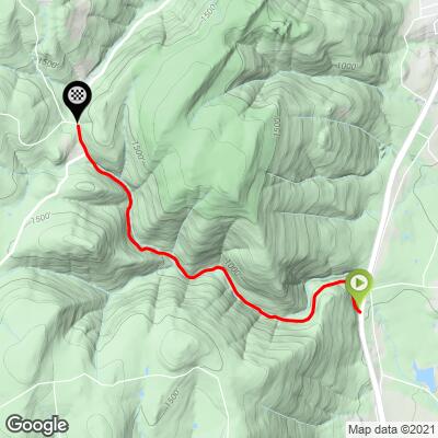
ROUTE MAP
MEMBER RATING
CURRENT WEATHER
PJAMM TRIPS ADVENTURE STARTER BUNDLES
Check out PJAMM Adventure's prepackaged (self-guided) cycling trips. They will help you plan, document and conquer your next adventure.
NEARBY CLIMBS (0) RADIAL PROXIMITY
FROM No Climbs Found
MEMBER REVIEWS & COMMENTS
Let us know what you thought of this climb. Signup for our FREE membership to write a review or post a comment.
Already have an account?
LOG IN HERE
chblue321
Did this climb as the ‘warm up' for some of the other climbs up the Catoctin Mountain. There are multiple limited parking areas on the ridge; I used Sand Flats Parking with the group I rode with. Add Wigville road to increase the climb to 1.88 FEITS and avoid US15. Not much traffic on Catoctin Hollow, as compared to Hamburg.
arielatom
This is one of the prettiest climbs in the area, even more so if you're able to catch it between November and April when the trees are bare. The challenge is getting to the climb; you have to ride on the shoulder of US 15 for a quarter mile, but it's well worth the hassle.
The climb itself is pretty gentle by area standards, although it can be extended by turning left onto Wigville Rd and following either that or Fox Tower Rd (both are paved / chip seal, whereas Mink Farm Rd has a coarse gravel section), which bring the total elevation differential closer to 1300ft. Or you can follow Catoctin Hollow and catch Park Central Dr (when open) for another great climb.