
23.9
PDI
11 mi
DISTANCE
3,868 ft
GAINED
6.3 %
AVG. GRADE
FULL CLIMB STATS
INTRO
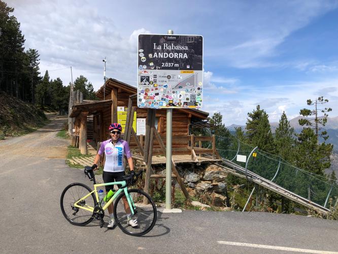
La Rabassa via La Peguera climbs 17.7 km (11.0 mi) from Sant Julià de Lòria to the high plateau of La Rabassa at 2033 m (6,670 ft), gaining 1179 m (3,868 ft) at a 6.3% average. It's the alternate way up to La Rabassa: instead of the more direct Juberri road (covered on our La Rabassa page), it swings east through the hillside village of Aixirivall and follows the old Peguera road through pine forest before the two routes merge for the final push.
It starts with a bang - the second kilometer averages 11.9%, with a brief ramp near 19% - then settles into a long, steady 6-7% grind through Aixirivall and the Bosc de la Peguera. Traditional stone bordes (hay barns) dot the meadows, the roadside Font de la Peguera spring sits at about 11 km, and the views back over the Sant Julià valley are almost constant. Around 14 km you reach the Peguera junction (about 1821 m), where the Juberri road joins, and the last 3.8 km climb to the finish at Naturland's upper Cota 2000 area.
The Peguera road was part of stage 11 of the 2015 Vuelta a España, an all-Andorran stage from Andorra la Vella to Els Cortals d'Encamp over six categorized climbs, and the La Rabassa summit hosted the 2018 Vuelta's stage 19 finish, where Thibaut Pinot passed Simon Yates in the final 200 m to win.
PLAN YOUR ROUTE
 We've partnered with Sherpa-Map.com to bring you the best route planning tool. With a PRO Membership you can use this climb as a reference when creating your route.
 La Rabassa via La Peguera is 17.7 km (11.0 mi) long and gains 1179 m (3,868 ft) at a 6.3% average, from 917 m (3,007 ft) in Sant Julià de Lòria to 2033 m (6,670 ft) at La Rabassa. There's about 62 m (205 ft) of descent mixed in near the Peguera junction.
Km 0-2: the steepest part of the climb - 7.8%, then 11.9% for the second kilometer as you turn up toward Aixirivall.
Km 2-10: a long, steady stretch at 5.4-7.7% per kilometer through Aixirivall and the Peguera forest.
Km 10-14: a more broken section around the Font de la Peguera and the Peguera junction, alternating between 6.6% and near-flat.
Km 14-17.7: the final approach to La Rabassa at 4.4-7.5% per kilometer.
Steepest sections: 100 yd (91 m) at 19.1%, 0.5 km at 11.5%, 1 km at 10.9%, 2 km at 9.7%, 5 km at 8.3% and 10 km at 7.3%.
Roadway: Paved the entire way. The Peguera road is a narrower, older secondary road than the Juberri side, with plenty of bends through the forest. Through Aixirivall it passes a fast-growing residential area, and the Comú de Sant Julià has been upgrading drainage and water lines along the Peguera road there since 2025, so expect the occasional short work zone. Andorran mountain roads are also prone to small rockfalls and washouts after heavy rain - ride the descent with that in mind.
Traffic: Light. Naturland's signed access is the Carretera de la Rabassa via Juberri, so the Peguera side is mostly local traffic from Aixirivall until the two roads meet. The final 3.8 km carry the Naturland-bound cars too, busiest on summer weekends and during ski season.
Parking: Sant Julià de Lòria has communal car parks and blue-zone street parking in the center, a few minutes from the start. At the top, Naturland has free parking at both its Cota 1600 and Cota 2000 areas, which makes a support-car meeting point easy.
Gear: Most of this climb is a steady 6-7% that suits a standard compact, but the steep second kilometer comes before you're warm, so have an easy gear ready from the start. You'll finish above 2000 m (6,562 ft), where it can be much cooler and windier than in the valley - bring a layer for the descent.
Provisions: Sort out food and drinks in Sant Julià de Lòria before you turn off toward Aixirivall; there are no shops on the Peguera road. The Font de la Peguera at about 11 km is a roadside spring, but don't count on it. At the top, Naturland's restaurants (El Foc at Cota 1600, La Borda at Cota 2000) are the only services on the mountain.
Before heading out on any cycling adventure check out our Things to Bring on a Cycling Trip and use our interactive check list to ensure you don't forget anything.
The finish sits in Naturland, Andorra's year-round mountain activity park, which spreads across two levels. The lower Cota 1600 area is home to the Tobotronc, a 5.3 km alpine coaster billed as one of the longest in the world. Up at Cota 2000, where this climb ends, the Naturland Bike Center runs more than 70 km of mountain-bike trails in summer, and in winter La Rabassa becomes Andorra's cross-country ski area.
On the way up, look out for the bordes - traditional stone barns built to store hay and shelter livestock through the winter. Many are beautifully preserved and some have been converted into mountain restaurants.
Across the valley, Coll de la Gallina and its Canòlich sanctuary make the obvious second climb from Sant Julià. Because you're finishing above 2000 m, conditions at La Rabassa can differ a lot from the valley - check current conditions before you go with our Weather tool.
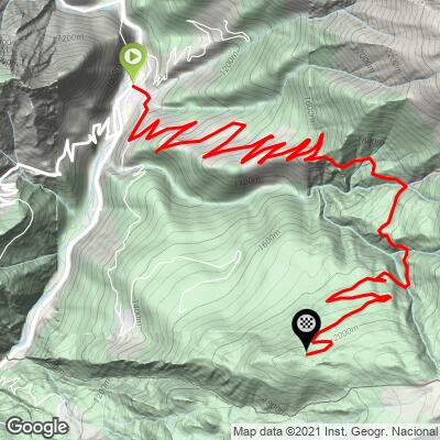
ROUTE MAP
MEMBER RATING
CURRENT WEATHER
PJAMM TRIPS ADVENTURE STARTER BUNDLES
Check out PJAMM Adventure's prepackaged (self-guided) cycling trips. They will help you plan, document and conquer your next adventure.
NEARBY CLIMBS (0) RADIAL PROXIMITY
FROM No Climbs Found
MEMBER REVIEWS & COMMENTS
Let us know what you thought of this climb. Signup for our FREE membership to write a review or post a comment.
Already have an account?
LOG IN HERE
