
25
PDI
7.6 mi
DISTANCE
3,373 ft
GAINED
8.3 %
AVG. GRADE
FULL CLIMB STATS
Page Contributor(s): Lisa Irizarry and Matthew Jiang, New York, New York.
INTRO
Coll de la Gallina climbs 12.2 km (7.6 mi) from Sant Julià de Lòria, gaining 1,028.1 m (3,373 ft) at an 8.3% average grade to a 1,910 m (6,266 ft) pass widely considered Andorra's hardest paved climb. Numerous sections push past 12%, with pitches reported as steep as 15-18% higher up.
The route runs through Aixovall and the small settlement of Bixessarri before passing the Sanctuary of Canòlich, a devotional site with sweeping views back over the Sant Julià valley, on a narrow, constantly winding road.
The pass itself is thought to take its name from an old livestock droving trail that once linked Canòlich's grazing pastures with the high passes above. This side of the mountain was paved well before the harder Fontaneda side on the opposite slope, which wasn't fully asphalted until 2015.
Coll de la Gallina has hosted the Vuelta a España repeatedly - Alessandro Ballan won here in 2008 shortly before becoming world champion, Alejandro Valverde won a summit finish in 2012, the race returned again in 2013, and Enric Mas won a stage-20 summit finish in 2018. PJAMM also has a longer combined route linking this climb with La Rabassa and Certers if you want to extend the day - see our Routes in the Area tool.
PLAN YOUR ROUTE
 We've partnered with Sherpa-Map.com to bring you the best route planning tool. With a PRO Membership you can use this climb as a reference when creating your route.
 Coll de la Gallina averages 8.3% over 12.2 km (7.6 mi), gaining 1,028.1 m (3,373 ft) from 904.0 m (2,966 ft) in Sant Julià de Lòria to 1,910.5 m (6,268 ft) at the pass.
The grade builds rather than staying constant. The lower kilometers through Aixovall and up to Bixessarri are the most moderate part of the climb, and effort increases noticeably above the Sanctuary of Canòlich, where multiple sections exceed 12% and the steepest pitches are reported near 15-18% on the narrow upper switchbacks. There's little flat ground anywhere on the route to recover on.
Roadway: Paved the entire way from Sant Julià de Lòria to the pass - this side of the mountain has been asphalted for considerably longer than the Fontaneda side on the opposite slope, which wasn't fully paved until 2015 for that year's Vuelta a España. The road itself is narrow and winds constantly, especially above Bixessarri.
Traffic: Generally light - this is a secondary mountain road serving a handful of small settlements and the Sanctuary of Canòlich, not a through route to elsewhere in Andorra. Expect more cars and cyclists in summer when the sanctuary and mountain restaurants draw day visitors.
Parking: Sant Julià de Lòria and Aixovall both have ordinary street parking near the base. Riders starting partway up can also base at Bixessarri, which we covers separately as its own shorter climb to the same pass.
Sant Julià de Lòria and Aixovall have supermarkets, bakeries, and cafes for a full pre-ride stop. Bixessarri, partway up, is a small settlement with limited services - don't count on finding anything there. Above the Sanctuary of Canòlich there's nothing at all until the pass.
Given the sustained 8%+ average and pitches into the mid-teens near the top, a compact crankset and an easy low gear are worth having - there's very little flat ground anywhere on this climb to shift up and recover.
Before heading out on any cycling adventure check out our Things to Bring on a Cycling Trip and use our interactive check list to ensure you don't forget anything.
The Sanctuary of Canòlich (Santuari de la Mare de Déu de Canòlich), passed partway up this climb, is Andorra's most important site of Marian devotion and a good excuse to stop - the terrace has some of the best views back over the Sant Julià de Lòria valley on the whole route.
The pass's name is thought to come from an old droving trail that once moved livestock between Canòlich's pastures and the high grazing grounds above.
Sant Julià de Lòria itself is a practical rather than resort-style base, with the fuller range of Andorra's hotels and restaurants concentrated closer to Andorra la Vella, a short drive away.
If you want to make a full day of it, the combined La Rabassa + Col de la Gallina + Certers route links this climb with two nearby neighbors in the same parish - a good option if you're based in the valley for more than one ride.
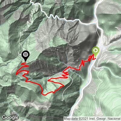
ROUTE MAP
MEMBER RATING
CURRENT WEATHER
PJAMM TRIPS ADVENTURE STARTER BUNDLES
Check out PJAMM Adventure's prepackaged (self-guided) cycling trips. They will help you plan, document and conquer your next adventure.
NEARBY CLIMBS (0) RADIAL PROXIMITY
FROM No Climbs Found
MEMBER REVIEWS & COMMENTS
Let us know what you thought of this climb. Signup for our FREE membership to write a review or post a comment.
Already have an account?
LOG IN HERE
