
18.8
PDI
5.2 mi
DISTANCE
2,446 ft
GAINED
8.6 %
AVG. GRADE
FULL CLIMB STATS
INTRO
Coll de la Gallina from Bixessarri is the upper, harder half of the north side of Andorra's best-known Vuelta climb: 8.4 km (5.2 mi) from the hamlet of Bixessarri, gaining 746 m (2,446 ft) at an 8.6% average from 1179 m (3,867 ft) to 1900 m (6,233 ft) at the pass. It skips the gentler lower road from Aixovall - covered on our Coll de la Gallina page - and starts right where the CS-600 turns serious.
This is the climb used for the time trial at the first Andorra Cycling Masters on 19 October 2025, an invitation-only exhibition that put four Grand Tour stars head to head over the 8.23 km course from Bixessarri. Primož Roglič won it in 25:39, 20 seconds ahead of Tadej Pogačar, with Isaac del Toro at 2:26 and Jonas Vingegaard at 3:45 - a benchmark few climbs anywhere can offer.
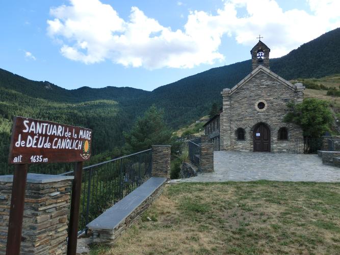
The road is narrow and constantly winding, and the hardest climbing comes early: the second and third kilometers both average over 10%. About 5 km (3.1 mi) up, you pass the Sanctuary of Canòlich at 1635 m (5,364 ft), and the final kilometers climb through forest to an open pass with views south to the Serra del Cadí and into Catalonia. With the summit at 1900 m (6,233 ft), check current conditions before you go with our Weather tool.
PLAN YOUR ROUTE
 We've partnered with Sherpa-Map.com to bring you the best route planning tool. With a PRO Membership you can use this climb as a reference when creating your route.
Coll de la Gallina from Bixessarri climbs 8.4 km (5.2 mi) from 1179 m (3,867 ft) to 1900 m (6,233 ft), gaining 746 m (2,446 ft) at an 8.6% average. There's almost no relief: every full kilometer averages between 7.7% and 10.4%. The steepest climbing comes early, just above Bixessarri, where the second and third kilometers average 10.4% and 10.1%.
The steepest 5 km average 9.8%, the steepest 2 km 10.9% and the steepest kilometer 11.4%. The steepest mile averages 11.2%, the steepest 500 m 12.3%, and the steepest 100 yards reach 18.8%. Past the Sanctuary of Canòlich, around km 5, the grade holds at 8-9% to the top, with only the last few hundred meters leveling out at the pass.
Roadway: The CS-600 is paved the entire way - a narrow road that winds constantly as it climbs from Bixessarri past Canòlich to the pass. At 1900 m (6,233 ft), the upper road can hold snow and ice well outside summer, so check conditions before an early- or late-season ride. From the top, the road continues as a paved through route down the south side via Fontaneda, which was asphalted ahead of the 2015 Vuelta a España.
Traffic: Light. The pass serves almost no through traffic, so you'll mostly share the road with locals, other cyclists and visitors to the Sanctuary of Canòlich. The exception is the Aplec de Canòlich on the last Saturday of May, the sanctuary's biggest annual gathering - expect much more traffic up to the sanctuary that day.
Parking: Bixessarri is a small hamlet, so most riders park in Sant Julià de Lòria or Aixovall (covered on our Coll de la Gallina page) and ride the lower CS-600 to the start. The Sanctuary of Canòlich, about 5 km (3.1 mi) up, makes a good meeting point for a support car.
Provisions: Stock up in Sant Julià de Lòria or Aixovall before you head up, and don't count on services in Bixessarri, at Canòlich or at the pass - carry enough water for the full 8.4 km (5.2 mi) and the descent.
Gear: With every kilometer between 7.7% and 10.4%, there's nowhere to recover, so a compact crankset with a 30-32 tooth low cog is the right choice for most riders. You'll finish more than 700 m (2,297 ft) above the start, where it can be much cooler and windier - bring a layer for the descent.
Before heading out on any cycling adventure check out our Things to Bring on a Cycling Trip and use our interactive check list to ensure you don't forget anything.
Bixessarri, where the climb starts, is built around the small Baroque church of Sant Esteve, completed in 1701 and listed as an asset of cultural interest by Andorra's heritage service in 2003, with a Baroque altarpiece dedicated to Saint Stephen. The hamlet is also the junction for the road west through the Vall d'Aos to Os de Civís, a village on Spanish territory - see our Os de Civis page for that climb.
The Sanctuary of Canòlich is covered in depth on our Coll de la Gallina page, but two practical details are worth knowing: guided visits run from mid-June to mid-September and must be booked 15 days ahead through the Sant Julià de Lòria tourist office (independent visits are free), and the Aplec de Canòlich on the last Saturday of May is the sanctuary's big annual gathering. At the top, the pass is a broad open space with long views south toward the western Serra del Cadí. For a loop, descend the paved south side through Fontaneda back toward Sant Julià de Lòria rather than retracing the north road.
ROUTE MAP

MEMBER RATING
CURRENT WEATHER
PJAMM TRIPS ADVENTURE STARTER BUNDLES
Check out PJAMM Adventure's prepackaged (self-guided) cycling trips. They will help you plan, document and conquer your next adventure.
NEARBY CLIMBS (0) RADIAL PROXIMITY
FROM No Climbs Found
MEMBER REVIEWS & COMMENTS
Let us know what you thought of this climb. Signup for our FREE membership to write a review or post a comment.
Already have an account?
LOG IN HERE
