
15.9
PDI
5.9 mi
DISTANCE
2,354 ft
GAINED
7.4 %
AVG. GRADE
FULL CLIMB STATS
INTRO
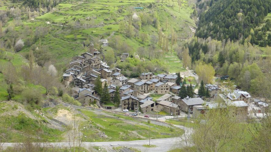
The best thing about this climb is where it ends. Os de Civís is in Spain, but the only road to it comes from Andorra - the CG-6 from Aixovall, up past Bixessarri and through the Vall d'Aos, and then a quiet slip across a border with no checkpoint, and a village of stone houses and slate roofs at the end of the asphalt. The kids go to school in Andorra, the Andorrans keep the road open, and the police are Catalan.
Our route is 9.5 km (5.9 mi) with 717 m (2354 ft) of climbing at 7.4%, from 938 m to 1646 m. It never settles into one rhythm: 9.4% in the second kilometer, a breather, 8% up to Bixessarri, a long steady stretch through the valley, and then 9.4% again around km 6. Above the valley the road narrows, and the last 1.5 km are the hardest of the day - 9.9% and then 12.8% up into the village.
Shared with the Coll de la Gallina for the first few kilometers, it splits off at Bixessarri and goes somewhere completely different: no pass, no Vuelta history, just a dead-end road to a place that feels like it got left behind by both countries. Stop at the Romanesque church of Sant Pere i Santa Margarida before you turn around.
PLAN YOUR ROUTE
 We've partnered with Sherpa-Map.com to bring you the best route planning tool. With a PRO Membership you can use this climb as a reference when creating your route.
Our route climbs 9.5 km (5.9 mi) from 938 m (3079 ft) to 1646 m (5401 ft), with 717 m (2354 ft) of climbing at an average of 7.4%.
km 0-1: 3.8% - out of Aixovall
km 1-2: 9.4%
km 2-3: 4.5%
km 3-4: 8% - up to Bixessarri, where the Coll de la Gallina road turns off
km 4-5: 7.2% - into the Vall d'Aos
km 5-6: 6.5%
km 6-7: 9.4%
km 7-8: 5.9%
km 8-9: 9.9%
km 9-9.5: 12.8% - up into Os de Civís
The steepest half kilometer is 12.5%, the steepest kilometer 10.5%, the steepest 2 km 8.9% and the steepest 5 km 8%.
Roadway: Asphalt to the village, then cobbled and unpaved lanes inside it. Riders describe the CG-6 as mostly in good shape, but it narrows beyond Bixessarri, and reports on the last stretch toward Os de Civís range from good to broken and patched. Take the descent from the village carefully - one rider's advice is to keep it under 40 km/h. Like every road in these valleys, it can hold snow and ice into spring at the top.
Traffic: Light. Above Bixessarri the road serves only the Vall d'Aos and Os de Civís, so you'll mostly meet residents and a few visitors on fine weekends. The busy road is the CG-1 through Aixovall at the bottom.
Parking: Aixovall sits right on the CG-1, and the easiest plan is to park in Sant Julià de Lòria, a couple of kilometers down the valley, and ride up to the start. Aixovall also has some street parking near the start.
Gear: A compact with a 30 or 32 tooth cog covers it - the average is moderate, but the finish into the village is steep and comes when your legs are already tired. The top is around 700 m above Aixovall, so bring a layer for the way down outside high summer.
Provisions: Sant Julià de Lòria and Aixovall have shops, bakeries and cafes; Bixessarri has very little. Os de Civís has restaurants serving Catalan mountain food and a hotel above the village, but it's a tiny place - check ahead rather than counting on them, and carry what you need.
Before heading out on any cycling adventure check out our Things to Bring on a Cycling Trip and use our interactive check list to ensure you don't forget anything.
In Os de Civís, walk up to the Romanesque church of Sant Pere i Santa Margarida, built on the site of an old castle with a wide view down the valley - its Gothic wall painting is now in the Diocesan Museum in La Seu d'Urgell. There's an old tower-shaped dovecote on the edge of the village, and the walks from here up the Setúria valley and along the Salòria river are worth a few hours off the bike. The village went without electricity or phone lines until 1982, and you can still feel how cut off it is.
For Sant Julià de Lòria and the Sanctuary of Canòlich, see our Coll de la Gallina pages - the Gallina from Bixessarri makes an obvious second climb from the same junction. For a big day out, our La Rabassa + Os de Civis + Aixas + Pujada Civis route links this climb with La Rabassa, Aixas and Pujada Civis - 128 km (79.5 mi) with 3830 m (12,566 ft) of climbing in full, though it's easy to cut down.
ROUTE MAP

MEMBER RATING
CURRENT WEATHER
PJAMM TRIPS ADVENTURE STARTER BUNDLES
Check out PJAMM Adventure's prepackaged (self-guided) cycling trips. They will help you plan, document and conquer your next adventure.
NEARBY CLIMBS (0) RADIAL PROXIMITY
FROM No Climbs Found
MEMBER REVIEWS & COMMENTS
Let us know what you thought of this climb. Signup for our FREE membership to write a review or post a comment.
Already have an account?
LOG IN HERE
