Hwy 243 - Banning Bike Climb - PJAMM Cycling

21.2
PDI
20.3 mi
DISTANCE
4,723 ft
GAINED
3.7 %
AVG. GRADE

FULL CLIMB STATS

Page Contributor(s): Bruce Hamilton, La Quinta, California, USA

INTRO

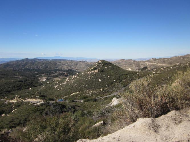
This climb begins at a section of Hwy 74 recognized as a scenic state route. At mile 11.5 we turn left onto Hwy 243 to complete the climb up to Pine Cove. Hwy 243 along this stretch is also a recognized scenic state route, and rightly so! We have many opportunities over the first 14 miles of the climb to look back to the east, down the large canyon we just climbed through to Valle Vista and Hemet far to the east. The landscape on the lower portion of the climb is quite stark and barren, but that is what permits the great easterly views down the canyon. There are exceptional views of the San Jacinto Mountains and Tahquitz Peak as we climb up towards Mountain Center and Idyllwild.

PLAN YOUR ROUTE

We've partnered with Sherpa-Map.com to bring you the best route planning tool. With a PRO Membership you can use this climb as a reference when creating your route.

See more details and tools regarding this climb's grade via our interactive Profile Tool.
Information Not Available

If you have any information regarding this climb, we'd like to hear from you. Click the CONTRIBUTE button to share your thoughts with us.

Information Not Available

If you have any information regarding this climb, we'd like to hear from you. Click the CONTRIBUTE button to share your thoughts with us.

Before heading out on any cycling adventure check out our Things to Bring on a Cycling Trip and use our interactive check list to ensure you don't forget anything.
Information Not Available

If you have any information regarding this climb, we'd like to hear from you. Click the CONTRIBUTE button to share your thoughts with us.

ROUTE MAP

MEMBER RATING

Difficulty: Challenging
4
Road
5
Traffic
5
Scenery

CURRENT WEATHER

PJAMM TRIPS ADVENTURE STARTER BUNDLES

Check out PJAMM Adventure's prepackaged (self-guided) cycling trips. They will help you plan, document and conquer your next adventure.
ALL TRIPS
Browse all of our prepackaged trips and find your next adventure!
San Gabriel Mountains
United States (CA)
38 ROUTES
43 POIs
ROUTE STATS (TOTAL)
677.5
mi
DISTANCE
80,483
ft
ELEV. GAIN

NEARBY CLIMBS (0) RADIAL PROXIMITY

FROM
No Climbs Found

MEMBER REVIEWS & COMMENTS

Let us know what you thought of this climb. Signup for our FREE membership to write a review or post a comment.
Already have an account?

Feb 28, 2022
difficulty: Challenging
scenery: 5
traffic: 5
road: 4
Feb 28, 2022
scenery: 5
traffic: 5
road: 4
Leaving this comment because I was not going to do the climb since there was no shoulder but the ride was so great I had to let anyone else know that the traffic is pretty light and there is lots of visibility and I felt very safe. Very beautiful ride that I will certainly do again.
ROUTE MAP
PROFILE TOOL
Route Data
S.G. (%)
hide
Segment Data
hide
CLIMB SUMMARY

Climb Summary

This climb begins at a section of Hwy 74 recognized as a scenic state route.  At mile 11.5 we turn left onto Hwy 243 to complete the climb up to Pine Cove.  Hwy 243 along this stretch is also a recognized scenic state route, and rightly so!  We have many opportunities over the first 14 miles of the climb to look back to the east, down the large canyon we just climbed through to Valle Vista and Hemet far to the east.  The landscape on the lower portion of the climb is quite stark and barren, but that is what permits the great easterly views down the canyon.  There are exceptional views of the San Jacinto Mountains and Tahquitz Peak as we climb up towards Mountain Center and Idyllwild.

IMG_2520.JPG     IMG_2529.JPG

So often we climb out of stark desert-like surroundings into desolate remote and unpopulated areas.  Not so for this climb.  There is much activity and vibrancy as we near and enter the music and artistic community of Idyllwild (do not pass through without having the apple pie at Idyllwild Bake Shop and Brew – you won’t be sorry!).

IMG_2533.JPGIMG_7200.JPG

Roadway and traffic report:  The roadway for both climbs was very good and traffic moderate but polite and seemed to travel more at the speed limit than many of the other Southern California “highway climbs” we have charted (e.g. Hwy 18 from both sides and Hwy 330).

Highway 243 – this is a great climb that can be done as an out-and-back from Hemet or Banning, or, better yet, by dropping down from your base camp at Idyllwild.  We have excellent views of back to Banning as we climb through a set of steep switchbacks around miles 2-3.  There are some great boulder formations and views of Lake Fulmor at mile 8.  We end in Pine Cove and we encourage a visit to Idyllwild 3 miles down 243 from the summit at Marion Road.