
20.2
PDI
7.1 mi
DISTANCE
2,860 ft
GAINED
7.6 %
AVG. GRADE
FULL CLIMB STATS
INTRO
PLAN YOUR ROUTE
 We've partnered with Sherpa-Map.com to bring you the best route planning tool. With a PRO Membership you can use this climb as a reference when creating your route.
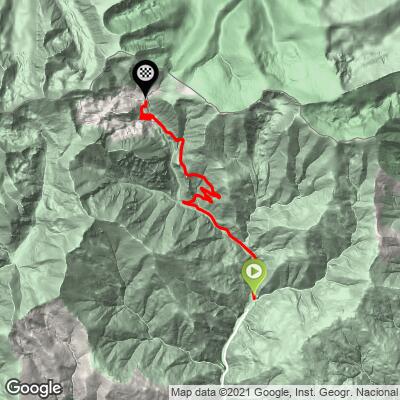
 Vallter climbs 872 m (2,860 ft) over 11.4 km (7.1 mi) at a 7.6% average, with just 42 ft (13 m) of descent. The steepest 0.4 km (0.25 mi) averages 12.8%, the steepest 0.8 km (0.5 mi) 11.6%, and the steepest kilometer (0.6 mi) 11.1%. The steepest 1.6 km (1 mi) averages 9.6%, the steepest 5 km (3.1 mi) 8.9%, and the steepest 10 km (6.2 mi) 7.8%. The steepest 91 m (100 yd) reaches 14.3%.
Things start gently out of Setcases, with the first couple of kilometers staying below 10%. The road then steepens as it climbs the valley wall in a series of hairpins, eases for a couple of kilometers where the grade can drop below 2%, and builds again toward the second set of hairpins and the finish, with the hardest ramps topping 12%.
Roadway: The road is paved all the way to the resort car park. It is narrow, barely wide enough for two vehicles to pass comfortably, and the surface is pale and imperfect but not rough enough to be uncomfortable. The climb is signposted along its whole length. Because Vallter is a ski resort, snow covers the upper road for much of the winter and spring, so summer through early autumn is the reliable season for cyclists.
Traffic: Traffic is lightest in summer on weekdays and busiest on ski-season weekends and summer weekends when hikers head for the Ulldeter circuit. Free-roaming cattle graze along the middle section, so slow down and give them room. The road is a dead end, so there is no through traffic.
Parking: Setcases has a free municipal car park (Aparcament municipal) a few minutes' walk from the start, plus a fountain on the Plaça Major and several restaurants. At the top, the resort has its own car park at about 2,155 m, and a restaurant or food truck operates during the resort's open season.
Setcases is your last reliable place to fill bottles before the climb, and the fountain on the Plaça Major is the easiest spot. There are no services between the village and the resort, where a restaurant or food truck is open in season.
A compact chainring with a 30-34 tooth cassette suits the 7.6% average and the 11-13% ramps. The finish is at 2,139 m (7,019 ft), so the temperature drops noticeably as you climb; carry a windproof layer for the summit and the descent, and watch for cattle on the road on the way down.
Before heading out on any cycling adventure check out our Things to Bring on a Cycling Trip and use our interactive check list to ensure you don't forget anything.
Setcases means "seven houses" and is named in documents from 965. The church has a Baroque altarpiece dedicated to Saint Michael, the only one of its kind in the Camprodon Valley, and the Ter River rises in the mountains just above the village. A short walk from the resort leads to the source of the Ter, and the Ulldeter circuit and routes toward Bastiments and Gra de Fajol are the main summer hikes. Winters are very cold, sometimes reaching around -20 degrees C.
From Barcelona it takes just over two hours by car via the C-17 to Vic and Ripoll and the C-38 to Camprodon. Camprodon, further down the valley, is the main base for visitors and for several other PJAMM climbs, including Coll de Burguerès and Coll de la Boixeda.
At 2,139 m (7,019 ft) the summit can be much colder and windier than the valley, so check conditions with our Weather tool before you go.
ROUTE MAP
MEMBER RATING
CURRENT WEATHER
PJAMM TRIPS ADVENTURE STARTER BUNDLES
Check out PJAMM Adventure's prepackaged (self-guided) cycling trips. They will help you plan, document and conquer your next adventure.
NEARBY CLIMBS (0) RADIAL PROXIMITY
FROM No Climbs Found
MEMBER REVIEWS & COMMENTS
Let us know what you thought of this climb. Signup for our FREE membership to write a review or post a comment.
Already have an account?
LOG IN HERE
