

15.6
PDI
5.1 mi
DISTANCE
2,230 ft
GAINED
8.1 %
AVG. GRADE
FULL CLIMB STATS
Page Contributor(s): Anja Kalan, Škofja Loka, Slovenija
INTRO
Locals call it Mali Vršič, the little Vršič, and with 19 hairpins stacked up the wall of the Kolpa valley it earns the name. Its other nickname, Medvedje črevo - the bear's gut - fits too, since brown bears really do live in these forests. The road is young by mountain-pass standards: it was built in 2007 to give Osilnica, the smallest municipality in Slovenia by population, a quicker way north to Kočevska Reka and on to Ljubljana.
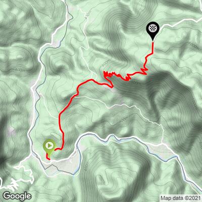
From Sela on the Kolpa it's 8.2 km (5.1 mi) at 8.1%, climbing 680 m (2230 ft) to the pass at 984 m. The opening kilometer through Osilnica is 7.9%, the second nearly flat along the valley, and then the road turns uphill and stays there: 10%, 9.3%, 10.2% and 10.2% for four kilometers in a row, with the steepest 500 m at 12.1%. The hairpins come thick and fast through the forest, and at the eighth there's a rest area and memorial with a view over the whole Osilnica valley - a good excuse to stop. At the top a big wooden carving of Peter Klepec, the strongman of Kolpa valley folk legend, watches riders arrive.
The pass is the finish line of Navkreber na Strmo Reber, a recreational hill climb from Osilnica held every year at the end of September since 2020; the seventh edition ran on 26 September 2026.
PLAN YOUR ROUTE
 We've partnered with Sherpa-Map.com to bring you the best route planning tool. With a PRO Membership you can use this climb as a reference when creating your route.
Overall: 8.2 km (5.1 mi) with 680 m (2230 ft) of climbing at an 8.1% average, from 317 m (1041 ft) to 984 m (3228 ft).
Km 0-2: 7.9% through Osilnica, then 3.1% along the valley floor.
Km 2-6: 10%, 9.3%, 10.2% and 10.2% - the hairpins, and the heart of the climb.
Km 6-8.2: 7% and 8.2%, then easing to the pass.
Steepest sections: 500 m at 12.1%, 1 km at 10.8%, 2 km at 10.6%, 5 km at 9.5%.
Roadway: Paved and in good shape - a two-lane road with a center line, guardrails on the drop side and rock cuttings on the inside of the bends, which is what you'd expect from a road built in 2007. The hairpins are tight but well engineered, and longboarders and motorcyclists love the descent for the same reason. Over the top, the north side drops at up to 14% toward Kočevska Reka. This is high forest country with real winters, so expect snow and ice on the upper hairpins from late autumn.
Traffic: Light. It's the main road out of one of the most thinly populated valleys in Slovenia, so you'll see the odd local car and, on summer weekends, groups of motorbikes enjoying the bends.
Parking: Park in the center of Osilnica, by the main road, a kilometer up from the start in Sela.
Gear: Four kilometers at around 10% with a 12% pitch in the middle call for a compact with a 30 or 32. The road is mostly in forest, so it stays fairly cool, but the valley can be hot and still in high summer.
Provisions: The Kovač inn in Sela, run by the same family since 1860, is right by the start and is the place to eat before or after. Fill up in the valley - there's nothing on the climb itself and nothing at the top but the carving and the view.
Before heading out on any cycling adventure check out our Things to Bring on a Cycling Trip and use our interactive check list to ensure you don't forget anything.
The Osilnica valley is one of the emptiest corners of Slovenia, and that's the appeal. The Kolpa below is a clear, cold river for swimming, rafting and canoeing in summer, with fly fishing on a catch-and-release basis, and the cliffs of the Kuželjska and Loška stena tower over the gorge. Nearby, the Krokar virgin forest is part of the UNESCO-listed ancient beech forests of Europe.
The municipality maps out ten cycling routes from Osilnica, from a 10 km loop through Padovo and Ribjek to a 79 km ride into Croatia through Čabar and back over the pass via Borovec and Banja Loka, and the 220 km Kolpa route follows the river down to Bela Krajina. If you climb Strma Reber as part of a loop, the descent to Kočevska Reka is the steeper side - keep your speed in check on the 14% sections.
ROUTE MAP
MEMBER RATING
CURRENT WEATHER
PJAMM TRIPS ADVENTURE STARTER BUNDLES
Check out PJAMM Adventure's prepackaged (self-guided) cycling trips. They will help you plan, document and conquer your next adventure.
NEARBY CLIMBS (0) RADIAL PROXIMITY
FROM No Climbs Found
MEMBER REVIEWS & COMMENTS
Let us know what you thought of this climb. Signup for our FREE membership to write a review or post a comment.
Already have an account?
LOG IN HERE
Anjakalan
Brautiful climb in amazing scenery. The road is almost newely paved.
