
17.2
PDI
11.2 mi
DISTANCE
3,204 ft
GAINED
5.2 %
AVG. GRADE
FULL CLIMB STATS
INTRO
The finish is a cross-country ski area, but the reason to ride up here is the view south. From the meadows around El Fornell, the north face of the Serra del Cadí lines up across the Cerdanya, with the Alt Urgell falling away to the west.
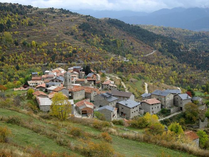
Getting there is a long, gentle build. The climb shares its first 7.5 km (4.7 mi) with our Martinet-Lles climb, up the LV-4036 through forest and the hamlet of Travesseres, then forks onto the Carretera d'Arànser. A near-flat kilometer and a half follows before the road rises through Arànser, a cluster of stone houses and slate roofs on the hillside. The last 5.5 km, on the ski-area road through pine forest, are the steepest part, holding 6 to 8.7%.
In all it's 18.0 km (11.2 mi) with 977 m (3,204 ft) of climbing at a 5.2% average, from 966 m (3,170 ft) to 1890 m (6,200 ft). The steepest kilometer is only 8.2%, so this is a long rhythm climb you can ride at your own pace - and an easy one to pair with something harder from the same village.
PLAN YOUR ROUTE
 We've partnered with Sherpa-Map.com to bring you the best route planning tool. With a PRO Membership you can use this climb as a reference when creating your route.
Desvio Aransa - El Fornell climbs 18.0 km (11.2 mi) from 966 m (3,170 ft) to 1890 m (6,200 ft) at a 5.2% average. The grade is easy for long stretches, and the steady climbing is all in the last third.
0 to 7.5 km (LV-4036): 3 to 8% in short swings through the forest above Martinet and on through Travesseres, averaging about 5%. Shared with Martinet-Lles.
7.5 to 9.5 km: The fork onto the Carretera d'Arànser, then a near-flat stretch of 0 to 2.5% with one brief dip.
9.5 to 12.5 km: 1 to 6% up through Arànser.
12.5 to 18.0 km: The ski-area road, 5.7 to 8.7% almost without a break to the finish.
The steepest kilometer averages 8.2%, the steepest 2 km 8.0% and the steepest 5 km 7.4%. A couple of short kicks touch about 15% over 100 yards.
Roadway: Asphalt right up to the ski area. The LV-4036 has a decent surface through the lower valley; the Carretera d'Arànser and the ski-area access road above the hamlet are narrower mountain roads. In winter the top of the road serves a snow-covered ski area at around 1900 m, so this is a ride for late spring to autumn.
Traffic: Light. Neither road goes anywhere but Lles, Arànser and the ski area, so outside the ski season you'll mostly share it with residents, walkers' cars and the odd farm vehicle.
Parking: Park in Martinet, the valley's service village, and roll to the start where the LV-4036 leaves the N-260. The same spot works for our Martinet-Lles and Coll d'Estana climbs. The ski area also has a large car park by the barrier at the top of the access road.
Gear: Nothing special - a compact and a 28 at the back handle the steepest kilometer comfortably. Bring a windproof layer: you finish more than 900 m above Martinet, and the descent is long and shaded.
Provisions: Martinet has shops and cafes, and Travesseres, on the shared section, has water. On the Arànser branch don't count on anything until the ski area, where the Fornell refuge is the station's base and kitchen in the ski season. Outside winter, carry what you need.
Before heading out on any cycling adventure check out our Things to Bring on a Cycling Trip and use our interactive check list to ensure you don't forget anything.
The Cerdanya is made for a multi-climb stay, and Martinet is a handy hub. Our Martinet-Lles page covers the main road on to Lles and Cap del Rec and the village's 1940s bunker park, so we won't repeat it here. Puigcerdà, east along the N-260, is the bigger town for hotels and the Cerdanya tourist office.
Up top, the Aransa ski area's tracks run through pine and fir forest between roughly 1950 and 2150 m, and in winter the Fornell refuge is the start of snowshoe routes to viewpoints like the Mirador del Pla de la Llet. Aransa is also one way in to the Estanys de la Pera lakes, a classic outing if you've brought a mountain bike. For a harder road day from the same corner of Martinet, try the Coll d'Estana.
ROUTE MAP

MEMBER RATING
CURRENT WEATHER
PJAMM TRIPS ADVENTURE STARTER BUNDLES
Check out PJAMM Adventure's prepackaged (self-guided) cycling trips. They will help you plan, document and conquer your next adventure.
NEARBY CLIMBS (0) RADIAL PROXIMITY
FROM No Climbs Found
MEMBER REVIEWS & COMMENTS
Let us know what you thought of this climb. Signup for our FREE membership to write a review or post a comment.
Already have an account?
LOG IN HERE
