Mt. Souda Bike Climb - PJAMM Cycling

40.7
PDI
15.6 mi
DISTANCE
5,853 ft
GAINED
6.9 %
AVG. GRADE

FULL CLIMB STATS

Page Contributor(s): Ties Arts, Bussum, Netherlands

INTRO

This 15.6 mile bike climb is located in Aseer Province, Saudi Arabia. The average gradient is 6.9% and there is a total elevation gain of 5,853 ft, finishing at 9,524 ft.

Use the profile tool, route map, and weather forecast to conquer this cycling climb.

See more details and tools regarding this climb's grade via our interactive Profile Tool.
Information Not Available

If you have any information regarding this climb, we'd like to hear from you. Click the CONTRIBUTE button to share your thoughts with us.

Information Not Available

If you have any information regarding this climb, we'd like to hear from you. Click the CONTRIBUTE button to share your thoughts with us.

Before heading out on any cycling adventure check out our Things to Bring on a Cycling Trip and use our interactive check list to ensure you don't forget anything.
Check with your embassy and the internet to assess the prudence of travelling to do this bike climb.

ROUTE MAP

MEMBER RATING

Not Yet Rated
-
Road
-
Traffic
-
Scenery

CURRENT WEATHER

PJAMM TRIPS ADVENTURE STARTER BUNDLES

Check out PJAMM Adventure's prepackaged (self-guided) cycling trips. They will help you plan, document and conquer your next adventure.
ALL TRIPS
Browse all of our prepackaged trips and find your next adventure!

NEARBY CLIMBS (0) RADIAL PROXIMITY

FROM
No Climbs Found

MEMBER REVIEWS & COMMENTS

Let us know what you thought of this climb. Signup for our FREE membership to write a review or post a comment.
Already have an account?
ROUTE MAP
PROFILE TOOL
Route Data
S.G. (%)
hide
Segment Data
hide

Climb Profile Not Found
CLIMB SUMMARY

Cycling Mount Souda, Saudi Arabia - John stands with Ahlam Zaid, Christiaan Beyers, and Steven Olyer on top of Mt. Souda

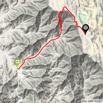
Cycling Mount Souda - Ride 15.6 miles gaining 5,856’ at 7% average grade

From left:  John, Ahlam Zaid (first Saudi women’s cycling champion),

Christiaan Beyers, and Steven Oyler

This was the most popular bike ride of the 11 we did in the Asir Mountains, and the only one with a Strava segment in place before our ride.  Yet, even the most cycled of Asir Mountain climbs had only nine riders before our climb.

HISTORIC VILLAGE

Cycling Mount Souda, Saudi Arabia - photo collage shows architecture and detailed doors in the Rijal Alma Village at climb's start

Be sure to visit Rijal Alma Village famous for its gingerbread house style architecture of ancient stone and mortar, just a few miles south of our climb start. The village is 900 years old and as of November 2021 is on the UNESCO tentative World Heritage list.

“Rijal village located in the Assir Region, and is the capital of the Rijal Almaa Province. The village was a natural corridor linking those coming from Yemen and the Levant to Makkah and Madinah which makes it an important regional commercial center. The village consists of about 60 palaces built from natural stone, clay and wood, and the palace consists of several floors. The Saudi Commission for Tourism and Antiquities has adopted a rehabilitation project for the village with the participation of partners from the public and private sectors. The village contains a heritage museum established by the efforts of the local inhabitants in order to save their regional heritage, and they have turned one of the forts into the museum headquarters since 1985. The Village of Rijal Almaa is located 45 km west of the city of Abha, a mountainous area bordered to the east by Al-Souda Center, and from the North Mahayel Asir province, and from the South Al-Darb province, on the west by the Red Sea” (Read more here). 

START

Cycling Mount Souda, Saudi Arabia - photo collage shows bikes at the climb's strt, brick roadway and tall clocktower in roundabout

We begin PJAMM’s climb at the clocktower at the roundabout on Highway 2442 in Al Shabain (PJAMM Strava segment).  Note that the shorter and steeper segment begins six miles up the road (PJAMM Strava segment).

Cycling Mount Souda, Saudi Arabia - two lane roadway with center divide at climb's start, mountains can be seen ahead in distance

EPIC CLIMB

Cycling Mount Souda, Saudi Arabia - photo collage shows PJAMM Cyclist on the climb as seen from above, two-lane highway roadway with jagged rocks on roadside and tall rock walls

This is another of the magnificent bike climbs in the Asir Mountains.  This one, however, must only be done during the off season in the Asir Region, which is winter time (generally November to February).  During the summer, the roadway is choked with cars and not manageable or safe via bicycle. In the winter, the best time to ride is early morning on a weekend (Friday/Saturday is the Saudi weekend).

Cycling Mount Souda, Saudi Arabia - photo collage includes Garmin reading 18% grade, road signs along the way

With no trees to block our views and extremely steep mountainside, the views up and down the mountain as we climb are unobstructed.  Even though we did this ride in the winter (off season) we did encounter much more vehicle traffic than on the 11 other World Top 100 climbs we documented in the Asir Mountains.  However, the traffic was not hazardous and in keeping with our other experiences in these mountains, many motorists offered encouragement, water, or stopped to chat.

Cycling Mount Souda, Saudi Arabia - photo collage, bike parked at park/field area, finish can be seen high in the mountains above, road signs along the climb

One daunting aspect of climbing by bike in the Asir Mountains is that invariably you can view the finish of your climb early on - commonly six or seven miles and over one vertical mile away (see bottom left photo above).

Cycling Mount Souda, Saudi Arabia - photo collage, bike parked agains low guardrail, tower with sharp spire can be seen in distance, baboons camouflage in grass on hillside, yellow road sign, PJAMM Cycling logo in corner

HAIRPINS AND CURVES

Cycling Mount Souda, Saudi Arabia - PJAMM Cyclist on roadway, extremely sharp sets of back to back hairpins can be seen on roadway in the distance

Cycling Mount Souda, Saudi Arabia - views of many U shaped hairpins as seen from above

No Asir Mountain bike climb is without many hairpins, many visible from above.

FINISH

Cycling Mount Souda, Saudi Arabia - photo collage at finish of climb, PJAMM Cyclist John Johnson finishes climb with hands in the air, riding next to multiple baboons perched on guardrail watching him, John stands next to plaque at top with Saudi men, views of hairpin turns looking down

A logical finish point for this climb is the viewpoint to the right just after finishing the six miles of hairpins coming up the mountain.  However, we chose to continue on to Mount Souda - the highest point in Saudi Arabia.

Cycling Mount Souda, Saudi Arabia - photo collage shows baboons climbing on car, on retaining wall, and all around the plaque at the top of the climb, denoting the highest point in Saudi Arabia

We encountered baboons on about half of the climbs we did in Saudi Arabia.  Baboons are native to this area and are commonly encountered along the road because motorists often stop to feed them.

ON THE WAY TO THE FINISH

Cycling Mount Souda, Saudi Arabia - photo collage shows John stopping for ice cream at a brightly colored ice cream truck, as well as a baboon on top of a fence who had just stolen milk from the truck, and a bunch of baboons fighting over the stolen milk

Near the finish we stopped for ice cream just as a baboon was stealing a milk carton from the ice cream truck.

CLIMB FINISH

Cycling Mount Souda, Saudi Arabia - climb finish at Mt. Souda, the highest point in Saudi Arabia, road closures

Mt. Souda - highest point in Saudi Arabia.

We continued on for 4.8 miles after the viewpoint expecting to finish very near the summit of Mount Souda, the highest point in Saudi Arabia.  Unfortunately, as of November 2021 the road is now closed for development and it is uncertain when it will reopen.

Cycling Mount Souda, Saudi Arabia - John cycling on two lane roadway approaching the finish of the climb

Photo as I approach the finish.