
44.6
PDI
39.2 mi
DISTANCE
9,416 ft
GAINED
3.8 %
AVG. GRADE
FULL CLIMB STATS
Page Contributor(s): Ricardo Osuna, Tijuana, Mexico
INTRO
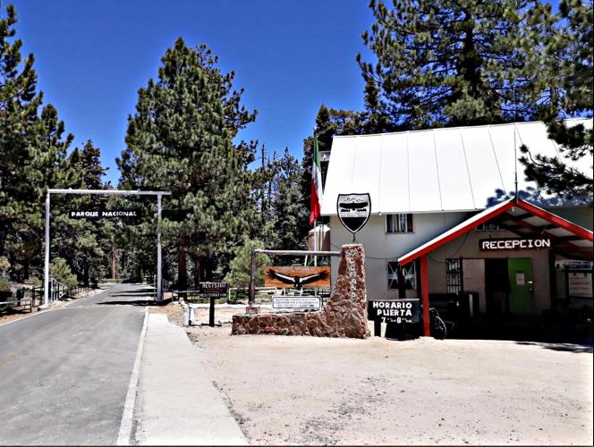
San Pedro de Martir is a 39.2-mile paved climb in Baja California, Mexico that gains 9,416 feet at a 3.8% average grade, finishing at 8,582 feet near the gate of Sierra de San Pedro Mártir National Park. It's currently ranked #67 in the world for difficulty in our database. The road climbs toward Mexico's premier astronomical observatory at 9,280 feet, in the shadow of 10,157-foot Picacho del Diablo, Baja California's highest peak - a reminder of just how high and remote this ride gets.
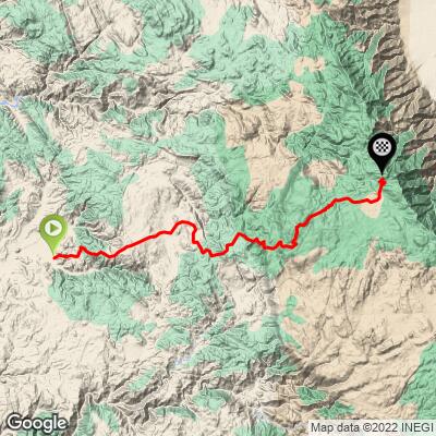
The route leaves Mexico's coastal Highway 1 at El Carricito and follows the paved Observatory/Park Road the entire way east into the mountains - one of the longest continuous paved ascents on the Baja California peninsula.
The road climbs through dramatic terrain changes: low desert scrub near the coast gives way to the pastoral San Telmo river valley, then chaparral and oak woodland, and finally pine forest as the road tops out near 9,000 feet.
Traffic is light for nearly the entire distance - this is a remote, sparsely populated part of Baja California, and the road exists mainly to serve the national park, a historic ranch, and Mexico's national observatory rather than through-traffic.
The upper section of this road (roughly kilometers 50 to 80) hosts the San Pedro Mártir Hill Climb, a motorcycle and car race billed as the longest hill climb competition in the world, run every October by Baja Tarmac Racing.
PLAN YOUR ROUTE
 We've partnered with Sherpa-Map.com to bring you the best route planning tool. With a PRO Membership you can use this climb as a reference when creating your route.
 This climb's overall average is 3.8%, but that figure blends a long, gradual low-desert approach with a genuinely steep mountain finish. The lower miles out of El Carricito through the San Telmo valley are gentle, while the upper section of the Observatory/Park Road - the same stretch used for the San Pedro Mártir Hill Climb motorsports race - includes multiple pitches over 15% grade and long stretches averaging 7%+ as the road switchbacks up through chaparral and pine forest toward the park gate.
See more details and tools regarding this climb's grade via the "Profile Tool" button.
Roadway: Paved two-lane road in good condition the entire way - Mexico's only paved route to Sierra de San Pedro Mártir National Park and its observatory. It's narrow in places with little to no shoulder and includes over 150 corners as it switchbacks up through the mountains, but the surface itself is consistently paved and well maintained. Do not follow a mapping app if it suggests cutting over from Highway 3 - that alternate route is unpaved, rugged, and impassable; the only way in is the paved road from Highway 1 at El Carricito.
Traffic: Very light. This road exists mainly to serve Rancho Meling, the national park, and the observatory rather than through-traffic, so expect long stretches with no cars outside of the annual October hill-climb race weekend.
Parking: There's no dedicated cyclist parking. Riders typically stage from the Highway 1 junction at El Carricito or from Rancho Meling (about 50 km / 31 miles up the road), a historic hotel and working ranch with rooms, camping, a pool, and a restaurant. Beyond Rancho Meling the road continues to the national park gate; the observatory itself sits further up and requires advance permission from staff to pass beyond the gate.
Provisions: This is a remote climb with almost nothing along the route - fuel up in Ensenada or San Quintín before heading to El Carricito, since there are no towns between the highway turnoff and the finish. Rancho Meling, roughly a third of the way up, is the one reliable stop for food, water, and a real bathroom - it's a working hotel and ranch, not a shop, so plan on a sit-down meal rather than a quick stop.
Weather: Elevation swings from low desert scrub to pine forest above 8,500 feet, so temperatures at the finish can be dramatically colder and windier than at the start. Check the PJAMM "Full Forecast" feature for conditions at the top before you go - the upper mountain can see snow outside of summer.
Before heading out on any cycling adventure check out our Things to Bring on a Cycling Trip and use our interactive check list to ensure you don't forget anything.
The San Pedro Mártir Hill Climb, billed as the world's longest hill climb race, runs on the upper section of this same road every October (Baja Tarmac Racing) - worth checking their schedule before you go, since the road may see race traffic or closures around the event.
Sierra de San Pedro Mártir National Park protects pine forest and granite peaks beneath Picacho del Diablo, Baja California's highest peak, and is home to reintroduced California condors, bighorn sheep, and mule deer - keep an eye out for wildlife on the quieter upper stretches of road.
If you want to see the observatory itself, note that the Observatorio Astronómico Nacional requires advance permission to pass beyond the gate near the top of this climb, and is closed to visitors during the last two weeks of December and first week of January.
ROUTE MAP
MEMBER RATING
CURRENT WEATHER
PJAMM TRIPS ADVENTURE STARTER BUNDLES
Check out PJAMM Adventure's prepackaged (self-guided) cycling trips. They will help you plan, document and conquer your next adventure.
NEARBY CLIMBS (0) RADIAL PROXIMITY
FROM No Climbs Found
MEMBER REVIEWS & COMMENTS
Let us know what you thought of this climb. Signup for our FREE membership to write a review or post a comment.
Already have an account?
LOG IN HERE
