
24.5
PDI
11.5 mi
DISTANCE
3,980 ft
GAINED
6.5 %
AVG. GRADE
FULL CLIMB STATS
INTRO
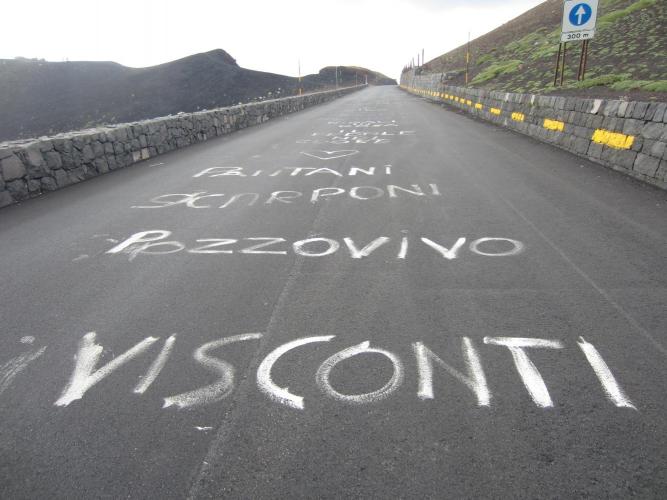
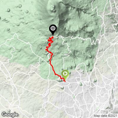
This climb follows Mount Etna's southern flank from Nicolosi up to Rifugio Sapienza, the main tourist and trailhead complex on Etna's south side. It covers 18.6 km (11.5 mi) and gains 1213 m (3,980 ft) at a 6.5% average grade, topping out at 1,930 m (6,332 ft) - the same paved corridor used by Salita Salto del Cane, which covers the road's Giro d'Italia history in detail.
Nicolosi itself earns its "Gateway to Etna" nickname - it's built largely from the mountain's dark basalt, and the Monti Rossi, a pair of grass- and pine-covered cinder cones formed during Etna's catastrophic 1669 eruption, rise right at the edge of town and make for an easy walk before or after the ride. Leaving Nicolosi, the road climbs steadily through vineyards and scrubland before the vegetation thins out almost completely, leaving mostly bare lava rock and pavement for the upper two-thirds of the climb.
The steepest ramp is near 15.3%, though most of the ascent settles into a long, sustained mid-single-digit grind rather than repeated hard pitches.
Etna has been in an ongoing effusive eruption since Jan 1, 2026, with lava flows confined to the uninhabited Valle del Bove on the volcano's eastern side - well away from this southern route. Free access on the south side has generally been maintained up to around 2500 m, comfortably above Rifugio Sapienza's elevation, though it's worth checking the INGV Etna Observatory's current bulletin before a trip.
PLAN YOUR ROUTE
 We've partnered with Sherpa-Map.com to bring you the best route planning tool. With a PRO Membership you can use this climb as a reference when creating your route.
 This route covers 18.6 km (11.5 mi) and climbs 1,213 m (3,980 ft) at a 6.5% average grade, finishing at 1,930 m (6,332 ft) near Rifugio Sapienza.
The steepest kilometer on this GPX averages 11.1%, and the single steepest 100-yard ramp reaches 15.3%, but there's no one decisive crux - the difficulty is the sustained length of the effort more than any single pitch. The trailing 5 km average settles to 7.9% and the trailing 10 km to 7.4%, both still solidly in climbing-gear territory, reflecting how little true flat ground this route offers anywhere along its length.
Roadway: Paved for the entire distance from Nicolosi to Rifugio Sapienza, with surface quality that varies from smooth, recently resurfaced sections to older, rougher pavement depending on the stretch. Etna's current eruptive activity (ongoing since January 2026) is confined to the Valle del Bove on the mountain's eastern flank, away from this southern approach, and free access has generally been maintained up to around 2,500 m on this side - above Rifugio Sapienza's elevation - though local authorities can adjust access on short notice based on guidance from the INGV Etna Observatory, so check current conditions before heading up.
Traffic: Light near Nicolosi, picking up somewhat in the upper kilometers as tour buses, jeep-tour vehicles, and day-trippers converge on Rifugio Sapienza for its cable car and hiking trails, especially around midday. Early mornings are noticeably quieter throughout.
Parking: Free street parking is available around Nicolosi's town center near the base of the climb. Riders wanting a shorter day can also start higher up, using the paid parking areas at Rifugio Sapienza itself as a turnaround point for an out-and-back on the upper mountain.
This is a long, sustained climb rather than a series of hard ramps, so a compact crank paired with a wide-range cassette (30-32 teeth or more) suits it well. Vegetation disappears almost entirely above the midpoint, leaving little shade and real sun and wind exposure on the open lava fields - sunscreen and a packable windproof layer for the descent are worth carrying, since temperatures near 1900 m can be dramatically cooler than down in Nicolosi. There's essentially nothing along the route itself, so fill bottles in town before you start; Rifugio Sapienza has bars, a restaurant, and a souvenir shop at the top if you need to refuel before heading back down.
Before heading out on any cycling adventure check out our Things to Bring on a Cycling Trip and use our interactive check list to ensure you don't forget anything.
Nicolosi is a practical, unpretentious base for riding Etna's south side, with hotels, trattorias, and everyday shops rather than a resort-town feel. The Monti Rossi cinder cones at the edge of town are worth the short walk - formed in the same 1669 eruption that destroyed much of the surrounding countryside, they're now covered in pine forest and give a good introduction to the volcano before you ride up its flank.
Catania, about 15 km away with its own international airport, makes a good alternative base for exploring the city's baroque center and street markets on a rest day, or for combining this ride with Etna's other paved approaches out of Zafferana Etnea, Belpasso, and Biancavilla - each climbs the same volcano from a different side, with its own character and history (this Nicolosi route shares its road with our Salita Salto del Cane page, which covers the climb's Giro d'Italia stage-win history in more depth).
Ride between late spring and early fall - snow can close the upper mountain in winter, when Etna Sud becomes a small ski area instead.
Riders looking to string together more of Etna's flanks in one trip can use our Routes in the Area tool to see the other nearby approaches.
ROUTE MAP
MEMBER RATING
CURRENT WEATHER
PJAMM TRIPS ADVENTURE STARTER BUNDLES
Check out PJAMM Adventure's prepackaged (self-guided) cycling trips. They will help you plan, document and conquer your next adventure.
NEARBY CLIMBS (0) RADIAL PROXIMITY
FROM No Climbs Found
MEMBER REVIEWS & COMMENTS
Let us know what you thought of this climb. Signup for our FREE membership to write a review or post a comment.
Already have an account?
LOG IN HERE
