
25.7
PDI
12 mi
DISTANCE
4,180 ft
GAINED
6.5 %
AVG. GRADE
FULL CLIMB STATS
INTRO
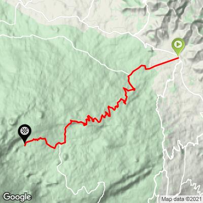
Mt. Etna (Piano Provenzana) climbs 19.3 km (12.0 mi) up the volcano's north flank from Linguaglossa to Piano Provenzana at 1,803 m (5,916 ft), gaining 1,274 m (4,180 ft) at a 6.5% average grade. It's one of several paved roads that reach high onto Etna's slopes from towns around the base, this one climbing the quieter, more forested north side rather than the busier south-flank routes out of Nicolosi or Zafferana Etnea.
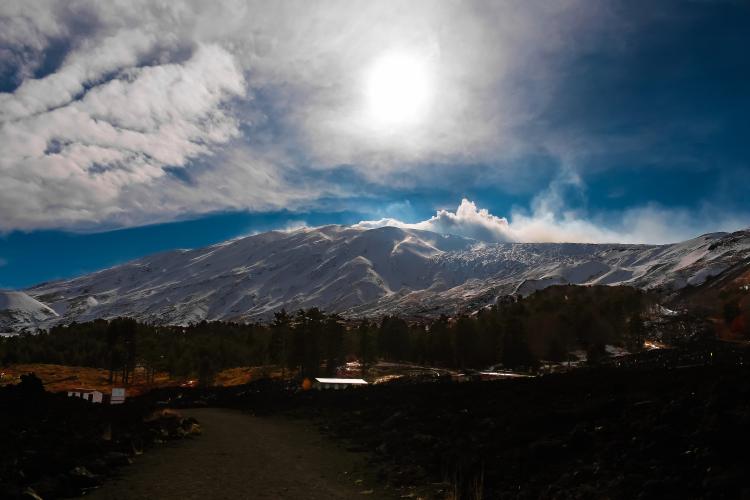
The road switchbacks up through the Ragabo pine forest, the highest-elevation pine forest in Sicily, before breaking into black volcanic ground near the top. Piano Provenzana was once a working ski resort - hotels, a chairlift, restaurants - until Etna's October 2002 eruption buried it in lava and burned roughly 2 km² of surrounding forest. Much of the cinder-field landscape near the finish dates from that eruption.
Etna has remained in a near-continuous eruptive phase through 2026, and this road has felt it directly - an August 2026 earthquake cracked the pavement between Rifugio Brunek and the Clan dei Ragazzi chalet, closing it until repairs restored the surface. The mountain is still active, so check current access before riding. The climb was also part of the 2011 Giro d'Italia route.
PLAN YOUR ROUTE
 We've partnered with Sherpa-Map.com to bring you the best route planning tool. With a PRO Membership you can use this climb as a reference when creating your route.
 Mt. Etna (Piano Provenzana) gains 1,274 m (4,180 ft) over 19.3 km (12.0 mi) at a 6.5% average grade, finishing at 1,803 m (5,916 ft). The steepest kilometer averages 11.2% and the steepest mile 10.3%, both concentrated in the final 3 km as the road switchbacks up through the 2002 lava flow above the pine forest. The lower miles out of Linguaglossa are a steadier, more moderate grind by comparison, gaining altitude gradually through orchards and forest before the road steepens for good in its closing kilometers.
Roadway: The road is paved the entire way from Linguaglossa to Piano Provenzana and was resurfaced with new asphalt in August 2026 after a magnitude 3.9 earthquake cracked and fissured the pavement between Rifugio Brunek and the Clan dei Ragazzi chalet. Etna has been in a near-continuous eruptive phase through 2026, and access to the upper mountain can be restricted on short notice - check current status with the comune di Linguaglossa or local news before you go.
Traffic: Light to moderate through Linguaglossa itself, where the road shares space with local traffic and summer visitors. Above town, traffic thins out considerably - Piano Provenzana no longer functions as the busy ski resort it once was, so the upper switchbacks see mostly other cyclists, hikers, and the occasional tour vehicle headed for the volcano excursions.
Parking: Free street parking is available throughout central Linguaglossa near the start. At the top, Piano Provenzana itself has a small free parking area near the rebuilt refuges and the trailhead for guided summit excursions, worth using if you want to explore on foot after the ride.
The entire route is paved and rideable on a standard road bike - no gravel or off-road sections, unlike the longer Catania-side route up Etna. Temperatures drop noticeably with the 1,274 m (4,180 ft) of elevation gain, and wind exposure increases above the tree line, so pack an extra layer even on a warm Sicilian day. Linguaglossa has grocery stores, cafes, and restaurants for stocking up before you start; above town there's nothing reliable until Piano Provenzana itself, so carry enough water and food for the full 19.3 km (12.0 mi) climb.
Before heading out on any cycling adventure check out our Things to Bring on a Cycling Trip and use our interactive check list to ensure you don't forget anything.
Linguaglossa is known as Etna's "north gate" and makes a quieter, less touristed base than the towns on the volcano's south side - it's also well known regionally for its hazelnuts, chestnuts, and a distinctive local sausage, all produced on the volcanic soil around town. Taormina, one of Sicily's most popular hillside towns, is only about 45 minutes away and makes an easy add-on before or after the ride.
Piano Provenzana's own story is worth knowing before you go: it was a working ski resort until Etna's October 2002 eruption buried the base area in lava, and what's visible near the finish today - hardened flows, cinder fields, a few rebuilt refuges - is what came after. Check our Weather tool for current conditions at both the base and the summit before heading out, since temperature and wind can shift quickly at elevation on this side of the mountain.
ROUTE MAP
MEMBER RATING
CURRENT WEATHER
PJAMM TRIPS ADVENTURE STARTER BUNDLES
Check out PJAMM Adventure's prepackaged (self-guided) cycling trips. They will help you plan, document and conquer your next adventure.
NEARBY CLIMBS (0) RADIAL PROXIMITY
FROM No Climbs Found
MEMBER REVIEWS & COMMENTS
Let us know what you thought of this climb. Signup for our FREE membership to write a review or post a comment.
Already have an account?
LOG IN HERE
