
15.5
PDI
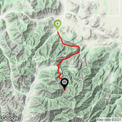
5.8 mi
DISTANCE
2,342 ft
GAINED
7.5 %
AVG. GRADE
FULL CLIMB STATS
INTRO
"Anderson Butte is another solid southern Oregon climb near Medford. The start on Griffin Creek Road is over moderate and variable grade. After 2.0 miles keep straight at the junction to head up Anderson Butte. Here the road narrows and the real nature of the ascent is revealed as the majority of the remainder of the climb is over double digit grade. You ride through thick trees for most of this section as the road twists up the steep hill. Near the stop the slope finally eases and the climb ends where the pavement ends." (This quote is presented with the approval of John Summerson, from his book, The Complete Guide to Climbing (by Bike), 2nd Edition, pg. 208.)
PLAN YOUR ROUTE
See more details and tools regarding this climb's grade via our interactive Profile Tool.
Information Not Available
If you have any information regarding this climb, we'd like to hear from you. Click the CONTRIBUTE button to share your thoughts with us.
Information Not Available
If you have any information regarding this climb, we'd like to hear from you. Click the CONTRIBUTE button to share your thoughts with us.
Before heading out on any cycling adventure check out our Things to Bring on a Cycling Trip and use our interactive check list to ensure you don't forget anything.
Information Not Available
If you have any information regarding this climb, we'd like to hear from you. Click the CONTRIBUTE button to share your thoughts with us.
ROUTE MAP
MEMBER RATING
CURRENT WEATHER
PJAMM TRIPS ADVENTURE STARTER BUNDLES
Check out PJAMM Adventure's prepackaged (self-guided) cycling trips. They will help you plan, document and conquer your next adventure.
NEARBY CLIMBS (0) RADIAL PROXIMITY
FROM No Climbs Found
MEMBER REVIEWS & COMMENTS
Let us know what you thought of this climb. Signup for our FREE membership to write a review or post a comment.
Already have an account?
LOG IN HERE