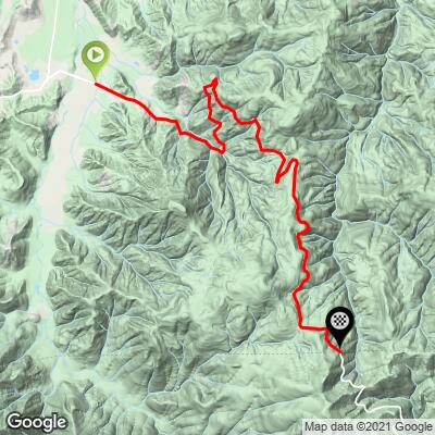
Happy Camp North (Grayback Rd) Bike Climb - PJAMM Cycling

5.6
FIETS
11.5 mi
DISTANCE
3,263 ft
GAINED
5.3 %
AVG. GRADE

FULL CLIMB STATS

INTRO

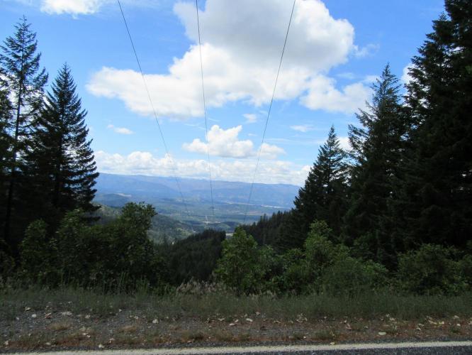
"This climb heads generally south toward the town of Happy Camp, California along a very isolated route. Never particularly steep, the grade is fairly steady through thick trees with good views in places when the trees part. About 2/3rds up you encounter steeper grade. The grade eases near the summit and the climb ends at an unmarked top very close to the California border. This is isolated climbing so carry whatever you may need on this hill." (This quote is presented with the approval of John Summerson, from his book, The Complete Guide to Climbing (by Bike), 2nd Edition, pg. 208.)

See more details and tools regarding this climb's grade via our interactive Profile Tool.
Information Not Available

If you have any information regarding this climb, we'd like to hear from you. Click the CONTRIBUTE button to share your thoughts with us.

Information Not Available

If you have any information regarding this climb, we'd like to hear from you. Click the CONTRIBUTE button to share your thoughts with us.

Before heading out on any cycling adventure check out our Things to Bring on a Cycling Trip and use our interactive check list to ensure you don't forget anything.
Information Not Available

If you have any information regarding this climb, we'd like to hear from you. Click the CONTRIBUTE button to share your thoughts with us.

ROUTE MAP

MEMBER RATING

Not Yet Rated
-
Road
-
Traffic
-
Scenery

CURRENT WEATHER

PJAMM TRIPS ADVENTURE STARTER BUNDLES

Check out PJAMM Adventure's prepackaged (self-guided) cycling trips. They will help you plan, document and conquer your next adventure.
ALL TRIPS
Browse all of our prepackaged trips and find your next adventure!
Crater Lake
United States (OR)
10 ROUTES
29 POIs
ROUTE STATS (TOTAL)
258.3
mi
DISTANCE
29,750
ft
ELEV. GAIN

NEARBY CLIMBS (0) RADIAL PROXIMITY

FROM
No Climbs Found

MEMBER REVIEWS & COMMENTS

Let us know what you thought of this climb. Signup for our FREE membership to write a review or post a comment.
Already have an account?
ROUTE MAP
PROFILE TOOL
Route Data
S.G. (%)
hide
Segment Data
hide

Climb Profile Not Found
CLIMB SUMMARY

CLIMB SUMMARY

Grayback Road from California

This is a gorgeous road and ride.  We are bordered by wildflowers, redwoods and forest as we climb 9 miles through the northern portion of pristine Klamath National Forest.  On occasion during the climb, we have breathtaking views of the distant heavily wooded rugged and essentially unpopulated Klamath Mountains.

IMG_1576.JPG     IMG_1609.JPG

It is highly unlikely you will “be in the area” and no one lives out there, so we doubt many will ever appreciate this hidden jewel.  However, if you do happen to be in the remote and rugged Northern California Happy Camp area, be sure to experience this ride – or, better yet, as an out-and-back incorporating Grayback south (California) and Grayback north (Oregon) at 43 miles and 6,360' of climbing – Map of out-and-back.  

While we saw only one private vehicle during our climb, we did encounter many logging trucks, so beware of those.  The roadway is in surprisingly good shape, given posted signs warning that it is not maintained.

Happy Camp - Grayback Road from Oregon

Happy Camp/Grayback Road north is the Oregon side of the Grayback Road south climb.  Both the south and north segments of this road offer gorgeous and remote views of the Pacific Coast Mountain Range and Siskiyou and Klamath National Forest.  

IMG_1619.JPG     IMG_1626.JPG

While there is moderate traffic on the southern segment, we encounter very little vehicular traffic along the Oregon side of the route.  The roadway is in very good condition and you will enjoy this peaceful and private climb that ends at the California border.  A nice out-and-back from the beginning of this route is up to the Oregon/California border, then down to the beginning of the Grayback Road south climb and back (Map – 43.6 miles 6,397’ of climbing).

Access to full Climb Summary requires a PJAMM Cycling PRO Membership!

It takes less than a minute to sign up & with your PRO membership you can:
  • Rate climbs, post comments and share your experiences on any of our climb pages
  • Create bucket lists of climbs & mark the dates you complete them
  • Weather data for all climbs - Start & Finish
  • Upload photos to your member page to customize your PJAMM Cycling experience
  • Utilize all of our interactive tools - Profile & Routes in Area
  • Download climb route .gpx files
LEARN MORE
SIGN UP

Already have an account? LOG IN HERE