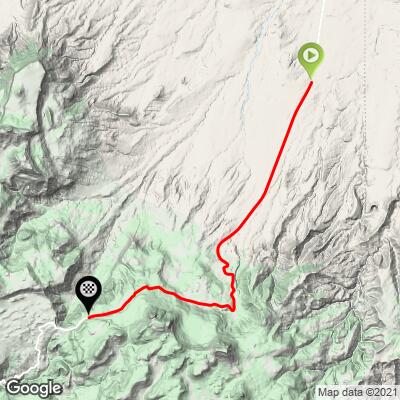
Buffalo Pass North Bike Climb - PJAMM Cycling

5.1
FIETS
8.3 mi
DISTANCE
2,260 ft
GAINED
5.1 %
AVG. GRADE

FULL CLIMB STATS

Page Contributor(s): Chris Monson, Blanding, Utah, USA

INTRO

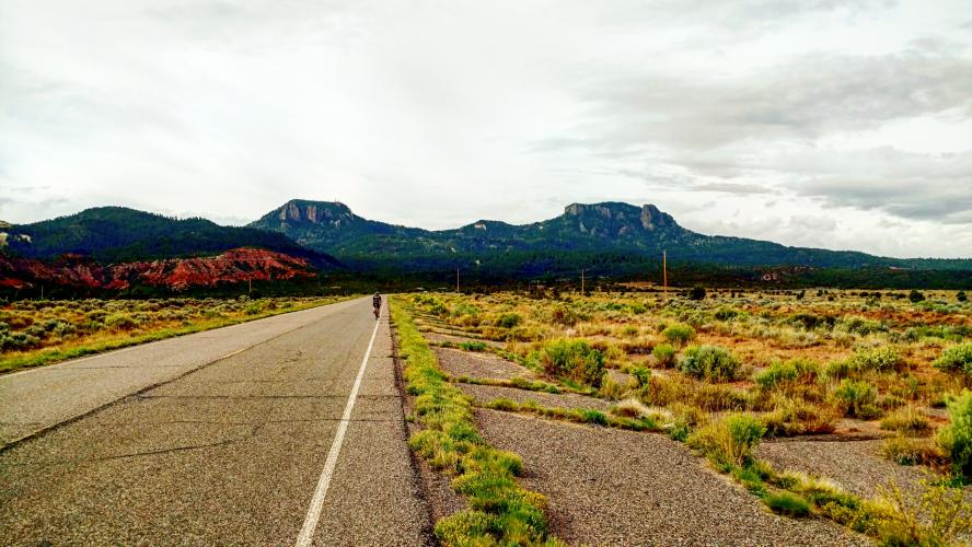
In the quiet northeast corner of Arizona, nestled in the heartland of the Navajo Nation lies a beautiful rise of mountains called the Lukachukai range. Buffalo Pass sits atop this range at 8,400’. On the east starting in the Red Valley you will have a very gentle rise heading to the bluffs of Lukachukai East. Other than a couple of 10% switch turns, this side of the hill is a pleasant ride up two thousand feet over approximately seven miles.
Average grade is 5.2% (5.8% climb only).  43% of the climb is at 5-10% and 12% is at 10-15%.  12% of the climb is at or above 10%.  The steepest quarter-mile is 13.2%.

See more details and tools regarding this climb's grade via the “Profile Tool” button.
Roadway: Two lane highway in fair to good condition with a no to a partial shoulder to ride in. 

Traffic:  Light.

Parking:  On the side of the road near climb start. 
Provisions:  This is an extremely remote ride, but there happens to be the Red Rock Trading Post in the middle of nowhere five miles north of the start of this climb (MapGoogle Map + Reviews). 
Before heading out on any cycling adventure check out our Things to Bring on a Cycling Trip and use our interactive check list to ensure you don't forget anything.
Consider doing this remote climb with Buffalo Pass South as an out and back - 26 miles gaining 3,900' (Map). 

ROUTE MAP

MEMBER RATING

Not Yet Rated
-
Road
-
Traffic
-
Scenery

CURRENT WEATHER

PJAMM TRIPS ADVENTURE STARTER BUNDLES

Check out PJAMM Adventure's prepackaged (self-guided) cycling trips. They will help you plan, document and conquer your next adventure.
ALL TRIPS
Browse all of our prepackaged trips and find your next adventure!
Arizona: Cycling and Spring Training
United States (AZ)
17 ROUTES
48 POIs
ROUTE STATS (TOTAL)
360.3
mi
DISTANCE
33,516
ft
ELEV. GAIN
Arizona: Mt. Lemmon
United States (AZ)
11 ROUTES
28 POIs
ROUTE STATS (TOTAL)
62.4
mi
DISTANCE
16,765
ft
ELEV. GAIN
The American Southwest
United States (AZ,NM,UT)
18 ROUTES
27 POIs
ROUTE STATS (TOTAL)
215.4
mi
DISTANCE
34,866
ft
ELEV. GAIN

NEARBY CLIMBS (0) RADIAL PROXIMITY

FROM
No Climbs Found

MEMBER REVIEWS & COMMENTS

Let us know what you thought of this climb. Signup for our FREE membership to write a review or post a comment.
Already have an account?
ROUTE MAP
PROFILE TOOL
Route Data
S.G. (%)
hide
Segment Data
hide

Climb Profile Not Found
CLIMB SUMMARY

Climb Summary

Contributed by Chris Monson, Blanding, Utah, USA

From the West:


In the quiet North East corner of Arizona, nestled in the heartland of the Navajo Nation lies a beautiful rise of mountains called the Lukachukai range. Buffalo Pass sits atop this range at 8,400’.  On the West side starting from the town that bears its name you will gently start up HWY N-13. Passing beautiful red cliffs the road twists and turns in a scenic panorama of sandstone cliffs and tall ponderosa pines. Climbing about 1,800 feet in approx. 6 miles you will find 15% switchbacks and gentle 6%-8% long hauls. At the top you will find a nice place for picnicking and a glorious view of the Red Valley to the East - location of the famed Shiprock. This is a wonderful high elevation treat rising high of the red desert that is Arizona.


Steepest ¼ mile and mile begin at mile 3.7 (15% and 10.8% respectively)


From the East:


In the quiet North East corner of Arizona, nestled in the heartland of the Navajo Nation lies a beautiful rise of mountains called the Lukachukai range. Buffalo Pass sits atop this range at 8,400’. On the East starting in the Red Valley you will have a very gentle rise heading to the bluffs of Lukachukai East. Other than a couple of 10% switch turns, this side of the hill is a pleasant ride up two thousand feet over approx. 7 miles. Don't forget the picnic for the views at the top.


Steepest ¼ mile and mile begin at mile  3.8 (13.%/9.1% respectively)