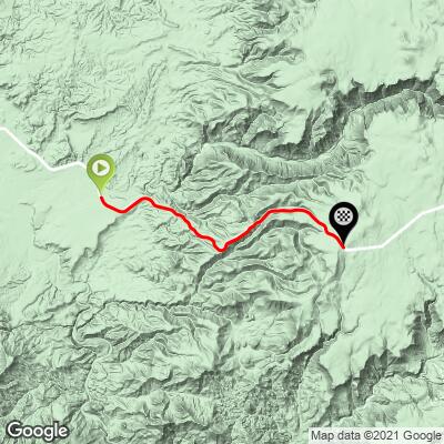
15.1
PDI
10.8 mi
DISTANCE
2,887 ft
GAINED
5 %
AVG. GRADE
FULL CLIMB STATS
INTRO
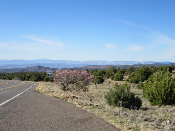
This is a HOT place - average high temperatures in June to August range from 99-102 degrees, so be prepared for that. Although, if you're traveling to Arizona in the summer, chances are you're coming prepared. We recommend this climb in the winter or spring, however.
"A long and shallow ascent, Route 260 begins within the desert and ends among Pondersoa Pines at altitude. Never steep, you will encounter multiple descednts along the way as you ride east. At the junction with Route 87 turn north for 0.8 miles to the unmarked top." (This quote is presented with the approval of John Summerson, from his book, The Complete Guide to Climbing (by Bike), 2nd Edition, pg. 126.)
PLAN YOUR ROUTE
Average grade is 5% (5.9% climb only). The bulk of the climb is under 10% grade - 34% is at 0-5% and 49% is at 5-10%. The steepest quarter-mile is 11.1% and steepest mile is 7.9%.
See more details and tools regarding this climb's grade via the “Profile Tool” button.
Roadway: Two lane highway in good condition with a shoulder to ride in most of the way.
Traffic: Mild, but traveling at highway speeds - this is not a climb for the traffic averse.
Parking: Just off a side road before the start of the climb - Map; Street View.
Provisions: None on this fairly remote climb. There is a Dollar Store two miles before the start of the climb in Camp Verde - Map.
Weather: It can be stifling hot in Arizona's Sonoran Desert so be sure to consult the PJAMM "Full Forecast" feature to assess what clothing and provisions to bring for the climb.
Before heading out on any cycling adventure check out our Things to Bring on a Cycling Trip and use our interactive check list to ensure you don't forget anything.
This is a nice climb to do if you are staying in Sedona as it is only 35 miles away. It is also just off I-17 between Sedona/Flagstaff and Phoenix, so consider stopping to do this one if you are traveling nearby.
Use the “Routes in Area” button on the menu bar to see other bike climbs in this area.
ROUTE MAP
MEMBER RATING
CURRENT WEATHER
PJAMM TRIPS ADVENTURE STARTER BUNDLES
Check out PJAMM Adventure's prepackaged (self-guided) cycling trips. They will help you plan, document and conquer your next adventure.
NEARBY CLIMBS (0) RADIAL PROXIMITY
FROM No Climbs Found
MEMBER REVIEWS & COMMENTS
Let us know what you thought of this climb. Signup for our FREE membership to write a review or post a comment.
Already have an account?
LOG IN HERE