Mingus (Hwy 89A) Bike Climb - PJAMM Cycling

22.3
PDI
13.8 mi
DISTANCE
3,997 ft
GAINED
5.3 %
AVG. GRADE

FULL CLIMB STATS

INTRO

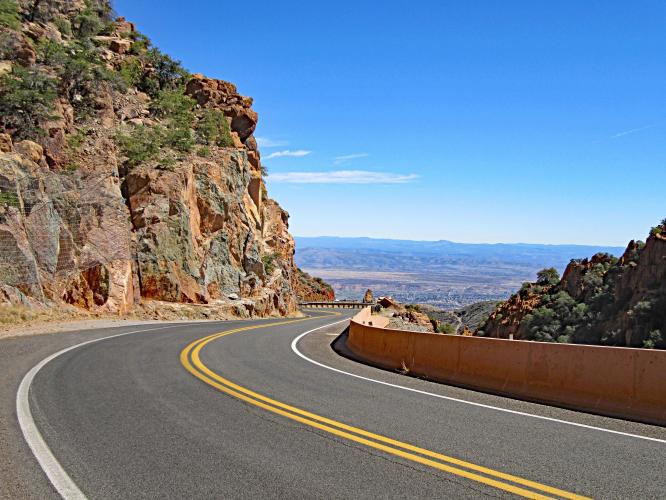
Just do it! We were so pleasantly surprised by this little known climb located smack dab in the middle of Arizona (with only 346 riders on Strava as of March 2016). This climb is about halfway between Sedona and Prescott on Highway 89A. We LOVED the Mingus Mountain climb for two primary reasons: (1) exceptional views back to the northeast of the spectacular Sedona mesa formations, and (2) the late 19th century restored copper mining town of Jerome. ​ 

PLAN YOUR ROUTE

We've partnered with Sherpa-Map.com to bring you the best route planning tool. With a PRO Membership you can use this climb as a reference when creating your route.
The 12 mile Mingus bike climb averages 5.1% (6% if descent is eliminated from the gradient equation).   10% (1.2 miles) of the climb is descent, 27% (3.3 miles) is at 0-5% grade, 59% (7.2 miles), 5-10%, 3.3% (0.4 miles) 10-15%, and 5% of the climb (0.1 mile) is at 15-20% grade.  The climb's steepest quarter-mile is 10.7% and steepest continuous mile 6.9%.  

See more details and tools regarding this climb's grade via the “Profile Tool” button.
Roadway:  Excellent.  The climb is on Highway 89A but the roadway is in great condition.

Traffic:  Mild to moderate.  

Parking:  We parked on Cement Plant Road 30 yards from Highway 89A and the start of the climb - MapStreet View
Provisions:  There is a gas station with snacks and beverages at the start of the climb.  You may also dine or get snacks and beverages in the charming town of Jerome at mile 4.5. 

Weather:  It can be hot in this area in the summer (average high is 100 degrees in July).  Consult the PJAMM "Full Forecast" feature for the time you expect to do this climb and prepare accordingly. 
Before heading out on any cycling adventure check out our Things to Bring on a Cycling Trip and use our interactive check list to ensure you don't forget anything.
We recommend staying in either Jerome or Sedona (23 miles) for this climb and also consider riding Sedona bike climb.  

ROUTE MAP

MEMBER RATING

Difficulty: Moderate
4.5
Road
3
Traffic
4.5
Scenery

CURRENT WEATHER

PJAMM TRIPS ADVENTURE STARTER BUNDLES

Check out PJAMM Adventure's prepackaged (self-guided) cycling trips. They will help you plan, document and conquer your next adventure.
ALL TRIPS
Browse all of our prepackaged trips and find your next adventure!
Arizona: Cycling and Spring Training
United States (AZ)
17 ROUTES
48 POIs
ROUTE STATS (TOTAL)
360.3
mi
DISTANCE
33,516
ft
ELEV. GAIN
Arizona: Mt. Lemmon
United States (AZ)
11 ROUTES
28 POIs
ROUTE STATS (TOTAL)
62.4
mi
DISTANCE
16,765
ft
ELEV. GAIN
The American Southwest
United States (AZ,NM,UT)
18 ROUTES
27 POIs
ROUTE STATS (TOTAL)
215.4
mi
DISTANCE
34,866
ft
ELEV. GAIN

NEARBY CLIMBS (0) RADIAL PROXIMITY

FROM
No Climbs Found

MEMBER REVIEWS & COMMENTS

Let us know what you thought of this climb. Signup for our FREE membership to write a review or post a comment.
Already have an account?

Jan 20, 2023
I've done this several times with and without a fully loaded BOB trailer. From both sides once you reach the summit there is camping on either side. Potato Patch is to the North side and is reserved and paid only. The S. side is 2.5 miles of fire/logging roads and is dispersed free camping. I've biked up from Phoenix to Prescott Valley (stop to get a 12 of good can ales) then up to the top. Prescott Valley to summit is much easier than the Sedona to summit route. The corners are tight and blind for approaching drivers. The views into the Sedona Red Rocks Valley are amazing and distracting. But, there are great restaurants and breweries on either end! Watch for cattle and turkeys at the summit area. They can get a wee bit startled and pissy.
Jun 11, 2021
difficulty: Moderate
scenery: 5
traffic: 4
road: 5
Jun 11, 2021
scenery: 5
traffic: 4
road: 5
A very cool hang glider launch at the top - I started at 5:30am and there was minimal traffic. Don't forget to hook in!
Mar 30, 2021
difficulty: Moderate
scenery: 4
traffic: 2
road: 4
Mar 30, 2021
scenery: 4
traffic: 2
road: 4
This climb really shines after reaching Jerome. Before Jerome, the traffic is fast, heavy, and there is no shoulder to speak of. After Jerome, the traffic falls off a bit and moves a bit slower, and the views greatly improve. If I were to do this again, I would probably just start and end in Jerome.
ROUTE MAP
PROFILE TOOL
Route Data
S.G. (%)
hide
Segment Data
hide
CLIMB SUMMARY

Cycling Highway 89A from Clarkdale to Mingus Mountain.

Ride 12.2 miles gaining 3,465’ at 5.1% average grade.

Climb summary by PJAMM’s John Johnson.

Just do it!  We were so pleasantly surprised by this little known climb smack dab in the middle of Arizona (with only 346 riders per Strava as of March 2016).  This climb is about halfway between Sedona and Prescott on Highway 89A.  We LOVED the Mingus Mountain climb for two primary reasons: (1) exceptional views back to the northeast of the spectacular Sedona mesa formations (as seen below). . .


. . . and (2) the late 19th century restored copper mining town of Jerome.  ​ After a couple of giant switchbacks at miles 3-4, we ride right through the very popular artist community of Jerome, which has a similar feel to rides through small Pyrenees villages in France.  We suggest riding the 12.2 mile climb, then having lunch or coffee back at Jerome, since this is close to the halfway point up the mountain.

The first copper claim was staked in Jerome in 1876, and by 1883 Jerome was a mining boomtown.  Originally, copper was mined via tunnels.  However, due to devastating fires occasionally erupting in the 88 miles of tunnels under the city, the mining process switched to open pit mining, which involves blasting with dynamite.  The open pit blasting caused many of Jerome’s hillside buildings to slide down hill -- the county jail slid 225 feet and now rests on the other side of the street from its original location.  

Photo:  Atlasobscura.com

Billions of dollars of copper was mined in and around Jerome in the late 19th and early 20th century.  The last mine closed in Jerome in 1953 and the boomtown, with a population at its peak of around 15,000 people, dropped as low as 50 in the late 1950’s.  

Jerome saw a resurgence in the 60’s and 70’s as it became somewhat of an artists’ community (along with the likes of Sedona to the northeast).  The Jerome Historical Society was formed in 1953 and has preserved much of the old mining town along with 11,000 photos, maps, historical documents, and more.  Bring a lock for your bike and visit the Jerome Mine Museum located on Main Street if you have time.  

Photos above are from Jeromehistoricalsociety.com.

Entering Jerome.


Traffic and Roadway Surface Report:  The roadway is in excellent condition and although there is a lot of traffic on this Highway, toward the top it does travel at slower speeds than traffic at the bottom.