8.2
PDI
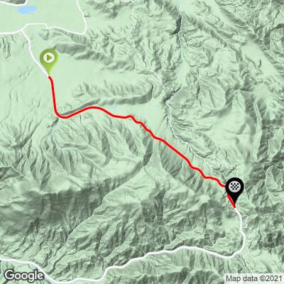
7.3 mi
DISTANCE
1,617 ft
GAINED
4.2 %
AVG. GRADE
FULL CLIMB STATS
INTRO
This 7.3 mile bike climb is located in CA, USA. The average gradient is 4.2% and there is a total elevation gain of 1,617 ft, finishing at 8,455 ft.
Use the profile tool, route map, and weather forecast to conquer this cycling climb.
Use the profile tool, route map, and weather forecast to conquer this cycling climb.
PLAN YOUR ROUTE
This climb averages 0%. The steepest quarter mile of this climb is 0%. NaN miles of the climb is at or above 10% grade. The gradient on this climb is broken down as follows:
See more details and tools regarding this climb's grade via our interactive Profile Tool.
See more details and tools regarding this climb's grade via our interactive Profile Tool.
Information Not Available
If you have any information regarding this climb, we'd like to hear from you. Click the CONTRIBUTE button to share your thoughts with us.
Information Not Available
If you have any information regarding this climb, we'd like to hear from you. Click the CONTRIBUTE button to share your thoughts with us.
Before heading out on any cycling adventure check out our Things to Bring on a Cycling Trip and use our interactive check list to ensure you don't forget anything.
Information Not Available
If you have any information regarding this climb, we'd like to hear from you. Click the CONTRIBUTE button to share your thoughts with us.
ROUTE MAP
MEMBER RATING
CURRENT WEATHER
PJAMM TRIPS ADVENTURE STARTER BUNDLES
Check out PJAMM Adventure's prepackaged (self-guided) cycling trips. They will help you plan, document and conquer your next adventure.
NEARBY CLIMBS (0) RADIAL PROXIMITY
FROM No Climbs Found
MEMBER REVIEWS & COMMENTS
Let us know what you thought of this climb. Signup for our FREE membership to write a review or post a comment.
Already have an account?
LOG IN HERE
JonLested
The signature climb featured in the Tour de Big Bear, Hwy 38 to Onyx Peak is where the TdBB KOM takes place. The gradient is very consistent and reasonably gentle. The road is in good shape, although there are sections where the shoulder is very narrow. Also key an eye out for the odd fist to volleyball-sized rock near the shoulder. Traffic is modest. The biggest challenge to this climb is the altitude since you top out at about 8450 ft. However, the spectacular views can take your mind off the feeling that you're breathing through a straw. Worth going out to do if you get up to Big Bear.