
15.3
PDI
10.8 mi
DISTANCE
2,998 ft
GAINED
5.2 %
AVG. GRADE
FULL CLIMB STATS
INTRO
Cefalù sits under a big rock on the coast, and this climb starts just behind the town and keeps the sea in view for much of the way up. It's 17.3 km (10.8 mi) to the top of the road on Pizzo Sant'Angelo, gaining 914 m (2998 ft) at 5.2%, and it hardly changes pace: every kilometer is between 4 and 6.4%, and the steepest one is 6.6%.
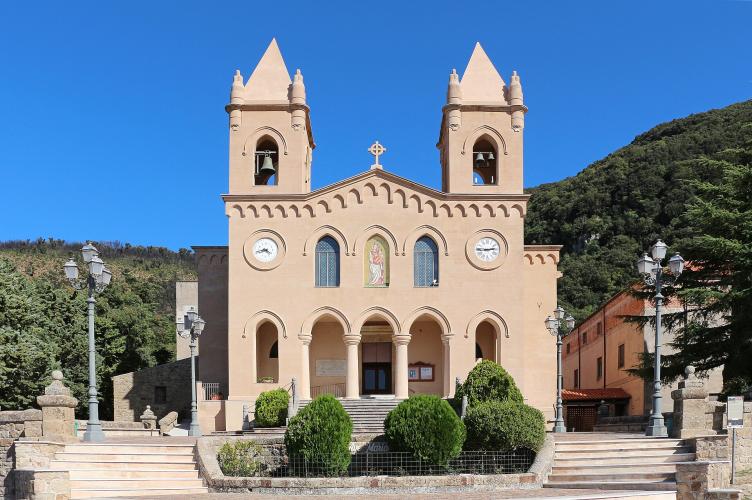
The first 12 km are on the SP54bis, a winding provincial road up through the hills above town to Gibilmanna. The Capuchin sanctuary there, with its two bell towers, has drawn pilgrims for centuries - the friars arrived in 1535 - and the view from the terrace in front goes straight down to the coast. It's a good place to stop and look back at how far you've come.
Past the sanctuary the road changes. Via Giubileo Magno climbs the last 5 km to the fenced INGV geophysical observatory near the top of Pizzo Sant'Angelo, and the surface gets rough - patched and broken in places, rideable on a road bike but much nicer on wider tires. The traffic disappears too, and on a clear day the Aeolian Islands sit out on the horizon.
PLAN YOUR ROUTE
 We've partnered with Sherpa-Map.com to bring you the best route planning tool. With a PRO Membership you can use this climb as a reference when creating your route.
From the SP54bis below Cefalù to the top of the road on Pizzo Sant'Angelo is 17.3 km (10.8 mi), gaining 914 m (2998 ft) at a 5.2% average, from 102 m (333 ft) to about 1000 m (3280 ft).
This is about as even as a long climb gets. Kilometer by kilometer: 5.8, 4.5, 5, 5.9, 6.1, 4.9, 6.2, 4, 4.8, 4.4, 5.7, 4.4, 5.6, 4.1, 5.5, 4.8 and 6.4%, and about 5% over the final 300 m to the observatory. The steepest 500 m is 8%, the steepest kilometer 6.6% and the steepest 5 km 5.6%.
The 12 km up to Gibilmanna are the smoother half; the 5 km above the sanctuary are the same gradient on a rougher road.
Roadway: Tarmac to the top. The SP54bis from Cefalù to Gibilmanna is a winding provincial road with plenty of tight bends. Above the sanctuary, Via Giubileo Magno is narrower and rough in places, with patched and broken asphalt - fine on a road bike if you take it steady, easier on 28 mm tires or wider. The road ends at the observatory fence, so that's your turnaround.
Traffic: Steady near Cefalù, especially in summer, and moderate up to Gibilmanna, where visitors drive up to the sanctuary. Above the sanctuary there's very little.
Parking: Park in Cefalù. The town gets very busy in summer, so leave the car on the side of town toward the SP54bis rather than near the old center and the beach. Starting at Gibilmanna instead cuts the ride to the rough final 5 km.
Gear: A standard compact is plenty for grades that never pass 8%. Wider tires, 28 mm or more, make the broken upper road much more pleasant, especially on the way down. The top at 1000 m can be a good deal cooler than the beach, so bring a light layer.
Provisions: Stock up in Cefalù and carry plenty of water in summer. Gibilmanna, around km 13, is the last stop with anything around it - there's nothing on the road above the sanctuary.
Before heading out on any cycling adventure check out our Things to Bring on a Cycling Trip and use our interactive check list to ensure you don't forget anything.
Cefalù is an easy base: it's on the train line from Palermo, it has hotels, restaurants and a long beach, and its Arab-Norman cathedral, begun by King Roger II in 1131, is part of a UNESCO World Heritage site. For a walk off the bike, the path up La Rocca, the rock behind the old town, gives you the same coastline you've been looking at from the climb.
Give Gibilmanna a few minutes on the way up or down. The Capuchins have been there since 1535, the church holds an old Byzantine-style fresco of the Madonna and Child, and the convent has its own museum, the Museo Fra Giammaria da Tusa.
The Madonie start right behind Cefalù. Our Pizzo Sant'Angelo (SP136) page reaches the same observatory by a different road out of town, and Piano Battaglia (a Collesano) and San Mauro Castelverde take you much higher into the park. Gratteri, a hill village a few kilometers west of the sanctuary, is worth the short ride over.
ROUTE MAP

MEMBER RATING
CURRENT WEATHER
PJAMM TRIPS ADVENTURE STARTER BUNDLES
Check out PJAMM Adventure's prepackaged (self-guided) cycling trips. They will help you plan, document and conquer your next adventure.
NEARBY CLIMBS (0) RADIAL PROXIMITY
FROM No Climbs Found
MEMBER REVIEWS & COMMENTS
Let us know what you thought of this climb. Signup for our FREE membership to write a review or post a comment.
Already have an account?
LOG IN HERE
