
21.3
PDI
13.4 mi
DISTANCE
3,959 ft
GAINED
5.4 %
AVG. GRADE
FULL CLIMB STATS
INTRO
PLAN YOUR ROUTE
 We've partnered with Sherpa-Map.com to bring you the best route planning tool. With a PRO Membership you can use this climb as a reference when creating your route.
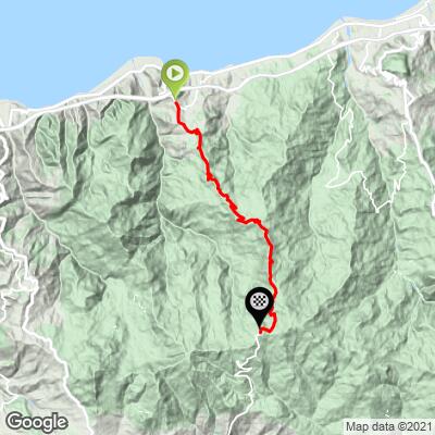
Our route covers 21.6 km (13.4 mi) from 356 m (1,169 ft) to 1,526 m (5,006 ft), a gain of 1,207 m (3,959 ft) at 5.4% on average. The first 2 km (1.2 mi) average 5.4%, and from there to about 14 km (8.7 mi) the road holds a steady 6.0-7.2%. The final 7.5 km (4.7 mi) are easier, averaging about 3.7%.
The steepest 100 yards (91 m) reach 14.9%, the steepest quarter-mile (0.4 km) averages 10.0%, and the steepest 1 km (0.6 mi) averages 8.3%. The hardest 5 km (3.1 mi) average 6.7% and the hardest 10 km (6.2 mi) average 6.5%, so most of the effort is in the first two-thirds of the climb.
Roadway: SP168 is paved the whole way. The Metropolitan City of Messina has contracted repaving of the worst-damaged stretches of the first section in Caronia, new guard rails and renewed markings, so surface quality may vary between repaired and unrepaired stretches. The upper road sees snow in winter and was ploughed open in March 2026, so expect cold and occasional ice at 1,500 m (4,921 ft) outside summer.
Traffic: SP168 links Caronia and the coast with Capizzi and the Nebrodi mountain towns, so you will share it with local traffic and park visitors rather than through traffic.
Parking: Our route starts on the Circonvallazione di Caronia at Ricchiò, part of Caronia Marina on Sicily's north coast, so use ordinary street parking in the village and keep driveways clear. Our short Marina di Caronia climb starts about 1.8 km (1.1 mi) away.
A compact crankset is a sensible choice for 21.6 km (13.4 mi) of mostly 6-7% climbing, and a light jacket is worth carrying: Portella dell'Obolo is at 1,526 m (5,006 ft) and snow has been recorded on the road as late as March.
Services are in Caronia and Capizzi, not on the climb. Fill bottles and carry food before you leave the village. The Fontana di Cecco at Portella dell'Obolo has been used as a water and refreshment checkpoint on organised rides across the Nebrodi, but there are no accommodation facilities at the pass.
Before heading out on any cycling adventure check out our Things to Bring on a Cycling Trip and use our interactive check list to ensure you don't forget anything.
The top of SP168 is Portella dell'Obolo, a forest pass that is a junction for walking routes into the Nebrodi, including the trail on to Pizzo Fau (1,686 m / 5,531 ft), about 2 km (1.2 mi) east of the pass. The Fontana di Cecco there has been used as a refreshment stop on long rides through the park.
Capizzi, 8 km (5.0 mi) south of the pass, is the closest town with lodging and a place to eat, and our Capizzi climb page covers that side. Pairing a coastal base in Caronia Marina with a day to Portella dell'Obolo gives you the contrast between the Tyrrhenian shore and the Nebrodi forests in one ride.
At 1,526 m (5,006 ft) the weather at the top can differ a lot from the coast, so check conditions at the base and the top with our Weather tool before you go.
ROUTE MAP
MEMBER RATING
CURRENT WEATHER
PJAMM TRIPS ADVENTURE STARTER BUNDLES
Check out PJAMM Adventure's prepackaged (self-guided) cycling trips. They will help you plan, document and conquer your next adventure.
NEARBY CLIMBS (0) RADIAL PROXIMITY
FROM No Climbs Found
MEMBER REVIEWS & COMMENTS
Let us know what you thought of this climb. Signup for our FREE membership to write a review or post a comment.
Already have an account?
LOG IN HERE
