Mt. Hamilton Bike Climb - PJAMM Cycling

18.9
PDI
18.4 mi
DISTANCE
4,272 ft
GAINED
3.9 %
AVG. GRADE

FULL CLIMB STATS

INTRO

Mt. Hamilton is one of the most popular bike climbs in the San Francisco South Bay. Mt. Hamilton West is the longest climb by bike in the entire Bay Area. We leave the populated Silicon Valley and are almost immediately in rural and agricultural surroundings. The roadway has minimal traffic, great views, and some big hairpins near the top. We end our climb at the Lick Observatory.

Mt. Hamilton is PJAMM's selection for fourth most scenic bike climb in the Bay Area. The PJAMM Adventure App's preloaded trips for the Bay Area's Top 10 Most Scenic can be viewed near the bottom of this page. 

PLAN YOUR ROUTE

We've partnered with Sherpa-Map.com to bring you the best route planning tool. With a PRO Membership you can use this climb as a reference when creating your route.
It would not be prudent to rely on Hamilton's puny sub-4% average grade in assessing the difficulty of this bike climb.  First, this is a long grinder that'll wear you down.  Second, there are two long descents that unfairly present Mt. Hamilton as an easy climb.  At mile 5.9 begins a 1.8 mile -3% grade and there is a second descent of one mile at -4% beginning at mile 11.  Eliminating these two descents raises Mt. Hamilton's average grade to a much more challenging 5.2% for 15 miles of climbing. 

15% (2.7 miles) are descent, 35% (6.4 miles) 0-5% and 50% (9.2 miles) 5-10% grade.  Mt. Hamilton's steepest quarter-mile is 8% (see gradient profile tool), and steepest continuous mile is 6.8%.  Only 1/10 of a mile is at 10% or greater.  Thus, Mt. Hamilton presents a nice grade that does not vary much over its 18 miles.  ofile Tool” button above.
Roadway:  Excellent condition and well maintained.

Traffic:  Mild.

Parking:  We have always parked at the beginning of the climb along the wide shoulder adjacent to the roadway - see MapStreetview
It may be a bit colder at the top than where you start 3,500' below - check the PJAMM Weather tool for the forecast at the top for the time you expect to finish. 
Before heading out on any cycling adventure check out our Things to Bring on a Cycling Trip and use our interactive check list to ensure you don't forget anything.
Booking your travels through one of these links helps us continue to bring you awesome info on climbing and cycling. Thank you! 

Mt. Hamilton is one of the five "must do" mountains to climb by bike in the Bay Area, along with Mt. Tamalpais (Marin County), Mt. St. Helena (Napa County), Mt. Diablo (Contra Costa County), and Mt. Umunhum (Santa Clara County).

ROUTE MAP

MEMBER RATING

Difficulty: Challenging
5
Road
4
Traffic
4.5
Scenery

CURRENT WEATHER

PJAMM TRIPS ADVENTURE STARTER BUNDLES

Check out PJAMM Adventure's prepackaged (self-guided) cycling trips. They will help you plan, document and conquer your next adventure.
ALL TRIPS
Browse all of our prepackaged trips and find your next adventure!
San Francisco Bay Area
United States (CA)
25 ROUTES
30 POIs
ROUTE STATS (TOTAL)
487.9
mi
DISTANCE
65,482
ft
ELEV. GAIN
San Francisco Bay Area: Most Scenic Bike Climbs
United States (CA)
10 ROUTES
0 POIs
ROUTE STATS (TOTAL)
86.9
mi
DISTANCE
25,759
ft
ELEV. GAIN

NEARBY CLIMBS (0) RADIAL PROXIMITY

FROM
No Climbs Found

MEMBER REVIEWS & COMMENTS

Let us know what you thought of this climb. Signup for our FREE membership to write a review or post a comment.
Already have an account?

May 16, 2024
difficulty: Challenging
scenery: 5
traffic: 4
road: 5
May 16, 2024
scenery: 5
traffic: 4
road: 5
One of my favorite climbs in Norcal. Easy grade, almost any bike with a cassette can climb this with a decent cadence. There is water around 3k feet in at the fire station and some at the top. You can continue on the backside and hook a U (stop at the bridge) for another 2k feet. Descent is very fun, little long but still fun. The two mini climbs on the way back are less fun.
May 16, 2021
difficulty: Challenging
scenery: 4
traffic: 4
road: 5
May 16, 2021
scenery: 4
traffic: 4
road: 5
Mt Hamilton West has a gentle grade but it is long, which makes it challenging. As of May 2021 they repaved the last 11 miles, from the intersection with Quimby up to the summit, the road is beautiful and very smooth. However, Lick Observatory (along with the restrooms) is still closed for Covid, so you cannot go up the short road (1/8 mile or so) leading to the observatory itself. However, water is still available at the entrance to the observatory road, which is nice.
ROUTE MAP
PROFILE TOOL
Route Data
S.G. (%)
hide
Segment Data
hide
CLIMB SUMMARY

Cycling Mt. Hamilton West is the most popular bike climb in Santa Clara County

Ride 18.4 miles gaining 4,300’ at 4% average grade. 

Over 10,000 Strava members have climbed Hamilton as of April, 2020

Climb summary by PJAMM’s John Johnson.

Mt. Hamilton is the most popular bike climb in the South Bay and has been featured in more Tour of California races than any other climb (see Tour of California section below). On any given day, particularly weekdays, you are bound to see many cyclists on this very fun road bike climb. This is a Bay Area Top 10 Most Scenic Bike Ride

Final mile to the summit.

Mt. Hamilton from the west is also the longest climb in the Bay Area, by a good stretch over Napa County’s Mt. St. Helena (18.2 v. 11.5 miles).

Both sides of Mt. Hamilton end amidst University of California observatories.

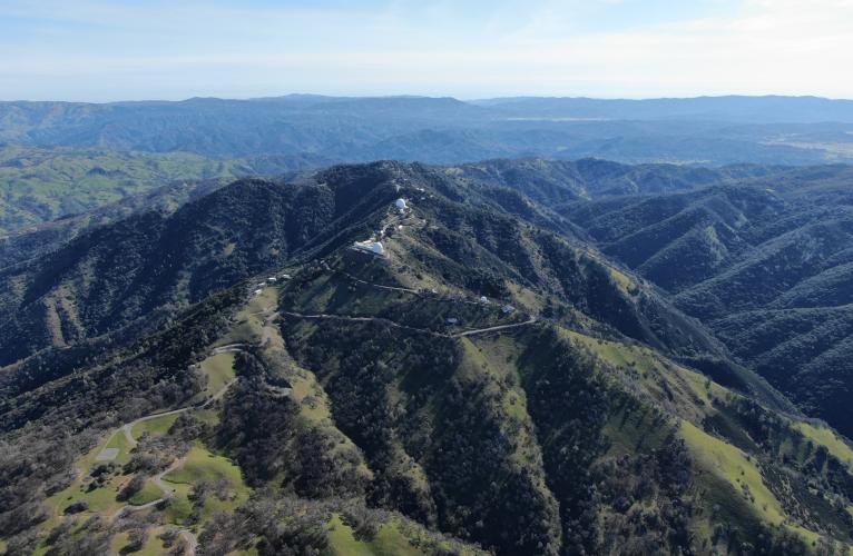
Aerial drone view of the top of Lick Observatory

This is the more popular, but more gradual, of the two Mt. Hamilton climb segments.  According to Strava, as of May 2015, there had been 12,230 attempts by 5,017 riders up the west side while only 3,913 attempts by 1,979 riders from the east.   The grade throughout the climb is fairly mild, although the overall 4% average grade for the 18.3 mile climb is a bit deceiving, as there are 558’ of descent included in that average.  If we remove the 2.5 miles of descent (at an average -2.5%), the climb averages about 5%.  

Start climb in Alum Rock, east of San Jose.

As we begin our climb (and for the first 4 miles), we have many excellent views of Northern California’s San Jose and Silicon Valley to the west and southwest.  

Just about one mile up the climb, San Jose is seen in the background.

San Jose is in view to the right the first few miles of the climb.

Within a couple of miles we feel as though we have left civilization behind (as much as one can really do that 10 miles from the Silicon Valley) and are soon passing through farmland and rolling oak-studded hills.  

The last six miles are up the mountain and through a series of switchbacks with a grade that increases to 5.7% on average for those final miles. Since the road was constructed between 1876 and 1887 with materials transported by horse and mule-drawn wagons, the grade could not be too steep, hence the many switchbacks and turns up the six mile ascent.  It is reported that there are approximately 365 turns on the roadway -- see Wikipedia-Lick Observatory for an excellent history of the Lick Observatory and Mt. Hamilton West.

Mt. Hamilton West generally consists of three separate climbs:

  • Climb 1: Ride 5.9 miles gaining 1,499’ at 5%. This segment ends at the beginning of the first of two descents on the route (this descent is 1.8 miles, dropping 315’ at -3.2% average and ends at Joseph D. Grant County Park - Grant Lake).

Cycling Mt. Hamilton  - cyclists on bike on road with San Jose and Silicon Valley in background

Views of San Jose along the first few miles of Climb 1.

Bike climb Mt. Hamilton  - cycling on bike riding on road with hillside and grazing cows in background.

Pasutre for much of the second half of Climb 1.

Bicycle ride Mt. Hamilton  - cyclist descending through trees

Climb 1 is followed by a 1.8 mile descent.

  •  Climb 2:  Ride three miles gaining 740’ at 5% followed by a one mile -3.8% descent of 203’.

The hills are studded with oak trees along this ride.

  • Climb 3:  Ride 6.3 miles gaining 1,970’ at 6% ending at the Lick Observatory.  This is where we encounter one of the most winding stretches of roadway in California (maybe the “whinediest” if you’re not prepared for this challenging climb).

Bike climb Mt. Hamilton  West - start of second climb - Hwy 130 road sign

Start of Climb 3.

Mt. Umunhum is visible as we climb the final segment of Mt. Hamilton West.

THE HAIRPINS OF MT. HAMILTON

“Tradition maintains that this road has exactly 365 turns” Wikipedia

This is one winding mountain road!

LICK OBSERVATORY - THE TOP

Lick Observatory is in view for much of the last half of the climb

We first see the observatory at mile 11 (top left photo)


The summit for the Mt. Hamilton West climb is the Lick Observatory, owned and operated by the University of California, this is the world’s first permanently occupied mountain-top observatory (the sign on the first building we come to at the top says “Residents Dining Hall” -- inactive as of 2015).

Biking Mt. Hamilton West - Lick Observatory entrance. Cyclist riding past front of Lick Observatory.

Lick Observatory at the top of the climb.

   Dome of the Lick Observatory after Mt. Hamilton bike bicycle ride.

View northwest.

Roadway Surface and Traffic Report:  The roadway surface is excellent and the traffic is mild to moderate, depending on the time of the week.  Of course, weekends are busier as there are exceptional views from the observatory, which is open to the public from Thursdays through Sundays noon to 5 p.m. (as of May 2015).  

Mt. Hamilton is in the Diablo Mountain Range.  It is reported that on clear days one can see the Santa Cruz Mountains, Monterey Bay, and Yosemite National Park (see, Wikipedia - Mt. Hamilton).  Unfortunately, on two of our times up Mt. Hamilton we were in the clouds much of the trip, and on the other we were suffering at about the halfway point of the Devil Mountain Double (not a time to truly relax and enjoy the views!).

Before heading out to cycle Mt. Hamilton, be sure to rely on our list of Things to Bring on a Cycling Trip, and use our interactive checklist to ensure you don't forget anything.

AMGEN TOUR OF CALIFORNIA

Mt. Hamilton is the most featured mountain climb in the history of the Tour of California, having been featured six times between 2006-2019.  Mt. Hamilton has never been a mountain-top finish in the ToC. (Note that ToC is on hiatus for 2020.)

  • 2008 Stage 3:
  • Queen Stage - Modesto - San Jose
  • 102.7 mile, 8,039’; eastern approach
  • Stage winner Robert Gesink (NED)
  • 2011 Stage 4:
  • Livermore to San Jose
  • 81.8 miles, 8,337’; eastern approach
  • Chris Horner (USA)
  • 2014 Stage 3:
  • San Jose to Mount Diablo
  • 107 miles, 10,574’; western approach
  • Lawson Craddock (USA)
  • 2015 Stage 3:
  •  East San Jose - San Jose
  • 105.5 miles  10,200’; eastern approach
  • Toms Skujiņš (LAT)
  • 2017  Stage 2:
  • Modesto to San Jose
  • 89.8 miles, 8,064; eastern approach
  • Rafal Majka (POL)
  • 2019 Stage 3:
  • East Stockton to Morgan Hill
  • 128.6 miles; eastern approach.
  •  Rémi Cavagna (FRA)

2019 Stage 3 Profile: May 14, 2019, 128 miles / elevation gain 9,667’

Peloton makes its way up Mt Hamilton West -- 2014 Stage 3.

MT. HAMILTON AT SUNSET

Beginning of Mt. Hamilton West bicycle climb

Sunset from Lick Observatory.

Cycling Mt. Hamilton - Lick Observatory aerial drone photo at sunset

Truly a sight to behold.