
27.5
PDI
5.4 mi
DISTANCE
3,086 ft
GAINED
11 %
AVG. GRADE
FULL CLIMB STATS
Page Contributor(s): Tier Arts, Bussum, Netherlands
INTRO
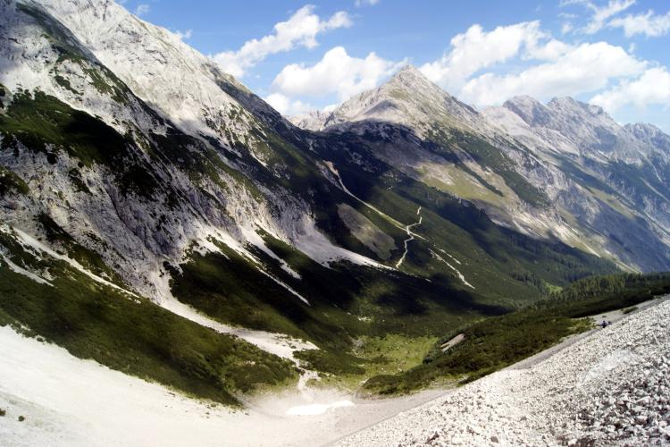
The Halltal is one of the steepest short climbs in Austria: just 8.6 km (5.4 mi) from Hall in Tirol, but gaining about 940.6 m (3,086 ft) at an 11.0% average, with pitches over 20% along the way. The road climbs south out of the Inn valley into the Karwendel Nature Park, following the historic Halltalstraße toward the Herrenhäuser, a cluster of centuries-old buildings tied to the valley's salt-mining history.
What makes the Halltal genuinely unusual is that it hasn't carried public car traffic since 2012, when rockfall and mudslide risk near the Bettelwurfeck forced a permanent closure to motor vehicles. The old toll road is now open only to walkers and cyclists (plus occasional maintenance and shuttle-taxi traffic), which makes for an almost car-free ascent on a paved surface - a rare combination for a climb this steep.
Hall in Tirol's salt mines shaped the region for centuries, and the Halltal itself takes its name from that history - "Hall" derives from the old word for salt. Today the valley sits inside the Karwendel Nature Park, the Alps' largest protected area, with limestone peaks of the Karwendel range rising steeply on both sides as you climb toward the Herrenhäuser.
PLAN YOUR ROUTE
 We've partnered with Sherpa-Map.com to bring you the best route planning tool. With a PRO Membership you can use this climb as a reference when creating your route.
 The Halltal gains 940.6 m (3,086 ft) over just 8.6 km (5.4 mi) for an 11.0% average - one of the highest average grades of any climb in Austria for its length. There's no easing in for a warm-up: the grade is demanding from the base and stays that way almost the entire way up.
Our data shows the steepest 500 m (0.3 mi) of the route averaging 20.0%, the steepest kilometer at 17.4%, and the single steepest quarter-mile hitting 22.2%. Pace conservatively from the first pedal stroke - there's very little of this climb that qualifies as easy.
Roadway: The Halltalstraße is fully paved and in good shape - it was built and maintained for decades as a toll road for cars. Since 2012, however, it has been permanently closed to public motor vehicle traffic following rockfall and mudslide activity near the Bettelwurfeck, higher up the valley; the pavement itself has held up well since the closure. Because rockfall risk is the reason for the closure in the first place, it's worth checking current signage at the valley entrance or the Naturpark Karwendel website for any temporary trail/road advisories before you ride, particularly after heavy rain.
Traffic: Essentially none. With the road closed to the public since 2012, the only vehicles you'll likely encounter are occasional maintenance trucks or the local Halltal taxi shuttle serving hikers. This is about as close to a private road as a paved climb gets.
Parking: Park near the gated entrance to the Halltalstraße on the southern edge of Hall in Tirol/Absam, where hikers and cyclists also stage for the valley. There's no parking available inside the valley itself since it's closed to cars.
Hall in Tirol has full services - grocery stores, bike shops, cafes - so stock up before heading into the valley, since there is nothing along the closed Halltalstraße itself beyond a seasonal hut or two near the Herrenhäuser. Carry all the water you'll need for the ride.
Low gearing is essential given the sustained 11% average and pitches over 20%; this is not a climb to attempt without a compact setup or a wide-range cassette. Because the valley is shaded and often cooler than the Inn valley floor, a light layer for the descent is worth carrying even on a warm summer day.
Before heading out on any cycling adventure check out our Things to Bring on a Cycling Trip and use our interactive check list to ensure you don't forget anything.
Hall in Tirol is a well-preserved medieval town just east of Innsbruck, with a historic old town built on centuries of salt-mining wealth - worth a wander before or after the ride. Innsbruck itself is only a short train ride away and makes a convenient base for a broader trip through Tirol's climbs.
Because the Halltal sits inside the Karwendel Nature Park, the largest protected area in the Alps, it's also a popular hiking and mountain-biking destination beyond just this road climb - expect to share the valley with walkers heading to the Herrenhäuser or the Bettelwurfhütte. Our Routes in the Area tool is a good way to see what else is nearby if you're building a multi-climb day around Innsbruck and the Inn valley.
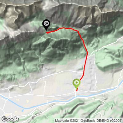
ROUTE MAP
MEMBER RATING
CURRENT WEATHER
PJAMM TRIPS ADVENTURE STARTER BUNDLES
Check out PJAMM Adventure's prepackaged (self-guided) cycling trips. They will help you plan, document and conquer your next adventure.
NEARBY CLIMBS (0) RADIAL PROXIMITY
FROM No Climbs Found
MEMBER REVIEWS & COMMENTS
Let us know what you thought of this climb. Signup for our FREE membership to write a review or post a comment.
Already have an account?
LOG IN HERE
